Map of Blount County - Blount County is a county located in the U.S. state of Alabama. Blount County Map showing cities, highways, important places and water bodies. Get Where is Blount County located in the map, major cities in Blount county, population, areas, and places of interest.
Blount County Map, Alabama
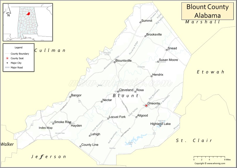
About Blount County Map, Alabama: The map showing the county boundary, county seat, major cities, highways, water bodies and neighbouring counties.
Most Viewed Links
Map of Blount County, Alabama
Blount County is a county located in the U.S. state of Alabama. It`s county seat is Oneonta. As per 2020 census, the population of Blount County was 59041 and population density of Blount was 91.6square miles. According to the United States Census Bureau, the county has a total area of 644.78 sq mi (1,670 km2). Blount County was established on 1818.
Blount County Facts
| Continent | North America |
| Country | United States |
| State | Alabama |
| County Seat | Oneonta |
| Largest City/Town | Oneonta |
| Established | February 6, 1818 |
| Total Area | 651 sq mi (1,686 sq km) |
| Land Area | 639 sq mi (1,655 sq km) |
| Water Area | 12 sq mi (31 sq km) |
| Population | 59,134 (Census 2020) |
| Population Density | 93 people per sq mi |
| Time Zone | Central Time Zone (CT) |
| Major Highways | Interstate 65, US 231, US 278, AL 75, AL 79, AL 160 |
| Major Rivers | Locust Fork of the Black Warrior River, Mulberry Fork of the Black Warrior River |
| Neighboring Counties | Cullman County, Marshall County, Etowah County, St. Clair County, Jefferson County, Walker County |
| Famous For | Covered bridges, Appalachian foothills, scenic countryside, and outdoor recreation |
| Top Attractions | Covered Bridge Trail, Palisades Park, Rickwood Caverns State Park, Locust Fork River |
| Official Website | Official Website |
About Blount County, Alabama
Blount County is located in north-central Alabama and was established in 1818. The county seat and largest city is Oneonta. The county lies within the southern Appalachian foothills and is known for its rolling mountains, river valleys, covered bridges, and outdoor recreation opportunities that attract visitors throughout the year.
Cities and Towns in Blount County, Alabama
| City/Town | Population (Census 2020) | Latitude & Longitude |
|---|---|---|
| Oneonta (county seat) | 6,921 | 33.9482°N, 86.4728°W |
| Cleveland | 1,245 | 33.9920°N, 86.5777°W |
| Snead | 835 | 34.1075°N, 86.3916°W |
| Altoona (partly in Blount County) | 948 | 34.0268°N, 86.3247°W |
| Susan Moore | 900 | 34.0812°N, 86.2877°W |
| Blountsville | 1,670 | 34.0817°N, 86.5919°W |
| Locust Fork | 1,186 | 33.9078°N, 86.6155°W |
| Highland Lake | 412 | 33.8832°N, 86.4550°W |
| Allgood | 622 | 33.9032°N, 86.5116°W |
| Rosa (CDP) | 509 | 34.0120°N, 86.5076°W |
| Straight Mountain (CDP) | 749 | 34.0035°N, 86.6441°W |
Best Golf Courses in Blount County, Alabama
| Golf Course | Location | Latitude & Longitude |
|---|---|---|
| Limestone Springs Golf Club | Oneonta | 34.0088°N, 86.5316°W |
| Palisades Golf Practice Area | Oneonta | 33.9570°N, 86.4620°W |
What are Major Roads and Highways in Blount County
Major highways connect the county to nearby regions and cities.
- Interstate 65 - major north-south interstate connecting Birmingham and Huntsville
- US Highway 231 - links Oneonta with Arab, Montgomery, and surrounding communities
- US Highway 278 - east-west route connecting Cullman, Oneonta, and Gadsden
- Alabama State Route 75 - connects Oneonta with Birmingham and Albertville
- Alabama State Route 79 - serves eastern Blount County and connects to Guntersville
- Alabama State Route 160 - links Blount County with Jefferson County communities
Neighboring Counties of Blount County
- Cullman County (northwest)
- Marshall County (northeast)
- Etowah County (east)
- St. Clair County (southeast)
- Jefferson County (south)
- Walker County (west)
What are Top Attractions in Blount County, Alabama
The county offers a mix of natural and cultural attractions.
| Main Sight Name | City | Famous For |
|---|---|---|
| Rickwood Caverns State Park | Warrior Area | Underground caves and geological formations |
| Horton Mill Covered Bridge | Oneonta Area | Historic covered bridge over the Black Warrior River |
| Easley Covered Bridge | Oneonta Area | Historic wooden bridge and scenic setting |
| Swann Covered Bridge | Cleveland | Alabama's longest historic covered bridge |
| Palisades Park | Oneonta | Scenic overlooks, hiking, and camping |
| Locust Fork River | Locust Fork | Kayaking, canoeing, and fishing |
| Mardis Mill Falls | Oneonta Area | Waterfall and natural scenery |
| Blount County Covered Bridge Trail | Countywide | Historic covered bridges and driving tours |
| Highland Lake | Highland Lake | Fishing and lakeside recreation |
| Blount County Memorial Museum | Oneonta | Local history and cultural exhibits |
| Snead State Community College Campus Area | Snead | Educational and community events |
| Locust Fork Scenic Areas | Countywide | Natural beauty and outdoor recreation |
Distance from Blount County to Nearby Cities
The following distances are measured by road (driving).
- Oneonta to Cullman (Cullman County), Alabama - 27 mi (43 km)
- Oneonta to Arab (Marshall County), Alabama - 25 mi (40 km)
- Oneonta to Guntersville (Marshall County), Alabama - 35 mi (56 km)
- Oneonta to Gadsden (Etowah County), Alabama - 38 mi (61 km)
- Oneonta to Trussville (Jefferson County), Alabama - 31 mi (50 km)
- Oneonta to Birmingham (Jefferson County), Alabama - 38 mi (61 km)
- Oneonta to Jasper (Walker County), Alabama - 44 mi (71 km)
- Oneonta to Pell City (St. Clair County), Alabama - 42 mi (68 km)
- Oneonta to Huntsville (Madison County), Alabama - 71 mi (114 km)
- Oneonta to Decatur (Morgan County), Alabama - 58 mi (93 km)
- Oneonta to Albertville (Marshall County), Alabama - 28 mi (45 km)
- Oneonta to Hoover (Jefferson County), Alabama - 45 mi (72 km)
- Oneonta to Anniston (Calhoun County), Alabama - 61 mi (98 km)
Nearest Airports
Nearest airport of Blount is Birmingham-Shuttlesworth International Airport (BHM / KBHM).
References
- QuickFacts - U.S. Census Bureau
- United States Census Bureau
- United States Geological Survey (USGS)
- National Geodetic Survey
- Official County Website
- Autauga County Map
- Baldwin County Map
- Barbour County Map
- Bibb County Map
- Blount County Map
- Bullock County Map
- Butler County Map
- Calhoun County Map
- Chambers County Map
- Cherokee County Map
- Chilton County Map
- Choctaw County Map
- Clarke County Map
- Clay County Map
- Cleburne County Map
- Coffee County Map
- Colbert County Map
- Conecuh County Map
- Coosa County Map
- Covington County Map
- Crenshaw County Map
- Cullman County Map
- Dale County Map
- Dallas County Map
- DeKalb County Map
- Elmore County Map
- Escambia County Map
- Etowah County Map
- Fayette County Map
- Franklin County Map
- Geneva County Map
- Greene County Map
- Hale County Map
- Henry County Map
- Houston County Map
- Jackson County Map
- Jefferson County Map
- Lamar County Map
- Lauderdale County Map
- Lawrence County Map
- Lee County Map
- Limestone County Map
- Lowndes County Map
- Macon County Map
- Madison County Map
- Marengo County Map
- Marion County Map
- Marshall County Map
- Mobile County Map
- Monroe County Map
- Montgomery County Map
- Morgan County Map
- Perry County Map
- Pickens County Map
- Pike County Map
- Randolph County Map
- Russell County Map
- St Clair County Map
- Shelby County Map
- Sumter County Map
- Talladega County Map
- Tallapoosa County Map
- Tuscaloosa County Map
- Walker County Map
- Washington County Map
- Wilcox County Map
- Winston County Map
- Alabama Counties
- Alaska boroughs
- Arizona Counties
- Arkansas Counties
- California County Map
- Colorado Counties
- Connecticut Counties
- Delaware Counties
- Florida County Map
- Georgia County Map
- Hawaii Counties
- Idaho Counties
- Illinois Counties
- Indiana Counties
- Iowa Counties
- Kansas Counties
- Kentucky Counties
- Louisiana Counties
- Maine Counties
- Maryland Counties
- Massachusetts Counties
- Michigan County Map
- Minnesota Counties
- Mississippi Counties
- Missouri Counties
- Montana Counties
- Nebraska Counties
- Nevada Counties
- New York Counties
- New Hampshire Counties
- New Jersey Counties
- New Mexico Counties
- North Carolina Counties
- North Dakota Counties
- Ohio County Map
- Oklahoma Counties
- Oregon Counties
- Pennsylvania Counties
- Rhode Island Counties
- South Carolina Counties
- South Dakota Counties
- Map of Tennessee
- Texas County Map
- Utah Counties
- Vermont Counties
- Virginia Counties
- Washington Counties
- West Virginia Counties
- Wisconsin Counties
- Wyoming Counties