Map of Fayette County - Fayette County is a county located in the U.S. state of Alabama. Fayette County Map showing cities, highways, important places and water bodies. Get Where is Fayette County located in the map, major cities in Fayette county, population, areas, and places of interest.
Fayette County Map, Alabama
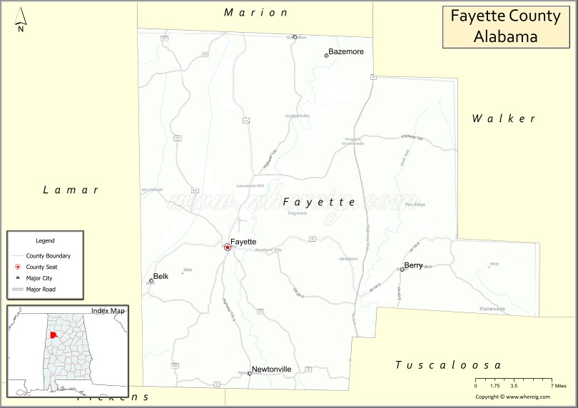
About Fayette County Map, Alabama: The map showing the county boundary, county seat, major cities, highways, water bodies and neighbouring counties.
Most Viewed Links
Map of Fayette County, Alabama
Fayette County is a county located in the U.S. state of Alabama. It`s county seat is Fayette. As per 2020 census, the population of Fayette County was 16148 and population density of Fayette was 25.7square miles. According to the United States Census Bureau, the county has a total area of 627.66 sq mi (1,626 km2). Fayette County was established on 1824.
Fayette County Facts
| Continent | North America |
| Country | United States |
| State | Alabama |
| County Seat | Fayette |
| Largest City/Town | Fayette |
| Established | December 20, 1824 |
| Total Area | 629 sq mi (1,629 sq km) |
| Land Area | 627 sq mi (1,624 sq km) |
| Water Area | 2 sq mi (5 sq km) |
| Population | 16,321 (Census 2020) |
| Population Density | 26 people per sq mi |
| Time Zone | Central Time Zone (CT) |
| Major Highways | US 43, US 43 Alternate, AL 18, AL 96, AL 171 |
| Major Rivers | Sipsey River, Luxapalila Creek |
| Neighboring Counties | Lamar County, Walker County, Tuscaloosa County, Pickens County, Marion County, Winston County |
| Famous For | Sipsey River, rural landscapes, coal mining history, and outdoor recreation |
| Top Attractions | Fayette Art Museum, Guthrie Smith Park, Sipsey River, Fayette Historic District, Hubbertville Community Park |
| Official Website | Official Website |
About Fayette County, Alabama
Fayette County is located in west-central Alabama and was established in 1824. The county seat and largest city is Fayette. The county lies within the Appalachian foothills and is known for its scenic countryside, forests, waterways, and long history of agriculture and coal mining. Its central location between Tuscaloosa and the Mississippi state line makes it an important regional center for surrounding rural communities.
Cities and Towns in Fayette County, Alabama
| City/Town | Population (Census 2020) | Latitude & Longitude |
|---|---|---|
| Fayette (county seat) | 4,237 | 33.6848°N, 87.8306°W |
| Berry | 1,114 | 33.6590°N, 87.6000°W |
| Glen Allen | 433 | 33.8915°N, 87.7314°W |
| Belk | 186 | 33.6465°N, 87.9304°W |
| Bankston | 291 | 33.6404°N, 87.6835°W |
| Newtonville (CDP) | 409 | 33.7579°N, 87.7245°W |
| Hubbertville (CDP) | 857 | 33.8232°N, 87.7568°W |
Best Golf Courses in Fayette County, Alabama
| Golf Course | Location | Latitude & Longitude |
|---|---|---|
| Fayette Country Club | Fayette | 33.6928°N, 87.8196°W |
| Fayette Municipal Golf Course | Fayette | 33.6874°N, 87.8353°W |
What are Major Roads and Highways in Fayette County
Major highways connect the county to nearby regions and cities.
- US Highway 43 - major north-south route connecting Fayette with Tuscaloosa, Hamilton, and Mississippi
- US Highway 43 Alternate - alternate route serving local communities in the county
- Alabama State Route 18 - east-west highway connecting Fayette with Vernon and Jasper
- Alabama State Route 96 - connects Fayette with Tuscaloosa County and Pickens County
- Alabama State Route 171 - links Fayette with Northport and Tuscaloosa
Neighboring Counties of Fayette County
- Marion County (north)
- Winston County (northeast)
- Walker County (east)
- Tuscaloosa County (south)
- Pickens County (southwest)
- Lamar County (west)
What are Top Attractions in Fayette County, Alabama
The county offers a mix of natural and cultural attractions.
| Main Sight Name | City | Famous For |
|---|---|---|
| Fayette Art Museum | Fayette | Regional art exhibits and cultural events |
| Guthrie Smith Park | Fayette | Walking trails, recreation facilities, and community events |
| Sipsey River | Countywide | Fishing, paddling, and scenic natural landscapes |
| Fayette Historic District | Fayette | Historic buildings and downtown heritage |
| Hubbertville Community Park | Hubbertville | Outdoor recreation and local gatherings |
| Luxapalila Creek | Western County | Wildlife viewing and nature exploration |
| Fayette County Courthouse | Fayette | Historic county landmark |
| Berry Historic Area | Berry | Small-town history and local culture |
| Glen Allen Heritage Site | Glen Allen | Rural Alabama heritage |
| Bankston Community Park | Bankston | Family recreation and outdoor activities |
| North River Wildlife Area | Eastern County | Hunting, wildlife observation, and nature photography |
| Fayette City Lake | Fayette | Fishing and outdoor recreation |
Distance from Fayette County to Nearby Cities
The following distances are measured by road (driving).
- Fayette to Berry (Fayette County), Alabama - 13 mi (21 km)
- Fayette to Glen Allen (Fayette County), Alabama - 16 mi (26 km)
- Fayette to Bankston (Fayette County), Alabama - 8 mi (13 km)
- Fayette to Vernon (Lamar County), Alabama - 22 mi (35 km)
- Fayette to Hamilton (Marion County), Alabama - 32 mi (52 km)
- Fayette to Jasper (Walker County), Alabama - 42 mi (68 km)
- Fayette to Northport (Tuscaloosa County), Alabama - 35 mi (56 km)
- Fayette to Tuscaloosa (Tuscaloosa County), Alabama - 38 mi (61 km)
- Fayette to Aliceville (Pickens County), Alabama - 40 mi (64 km)
- Fayette to Winfield (Marion County), Alabama - 23 mi (37 km)
- Fayette to Birmingham (Jefferson County), Alabama - 73 mi (117 km)
- Fayette to Columbus, Mississippi - 54 mi (87 km)
- Fayette to Tupelo, Mississippi - 83 mi (134 km)
Nearest Airports
Nearest airport of Fayette is Fayette Airport - Richard Arthur Field-M95.
References
- QuickFacts - U.S. Census Bureau
- United States Census Bureau
- United States Geological Survey (USGS)
- National Geodetic Survey
- Official County Website
- Autauga County Map
- Baldwin County Map
- Barbour County Map
- Bibb County Map
- Blount County Map
- Bullock County Map
- Butler County Map
- Calhoun County Map
- Chambers County Map
- Cherokee County Map
- Chilton County Map
- Choctaw County Map
- Clarke County Map
- Clay County Map
- Cleburne County Map
- Coffee County Map
- Colbert County Map
- Conecuh County Map
- Coosa County Map
- Covington County Map
- Crenshaw County Map
- Cullman County Map
- Dale County Map
- Dallas County Map
- DeKalb County Map
- Elmore County Map
- Escambia County Map
- Etowah County Map
- Fayette County Map
- Franklin County Map
- Geneva County Map
- Greene County Map
- Hale County Map
- Henry County Map
- Houston County Map
- Jackson County Map
- Jefferson County Map
- Lamar County Map
- Lauderdale County Map
- Lawrence County Map
- Lee County Map
- Limestone County Map
- Lowndes County Map
- Macon County Map
- Madison County Map
- Marengo County Map
- Marion County Map
- Marshall County Map
- Mobile County Map
- Monroe County Map
- Montgomery County Map
- Morgan County Map
- Perry County Map
- Pickens County Map
- Pike County Map
- Randolph County Map
- Russell County Map
- St Clair County Map
- Shelby County Map
- Sumter County Map
- Talladega County Map
- Tallapoosa County Map
- Tuscaloosa County Map
- Walker County Map
- Washington County Map
- Wilcox County Map
- Winston County Map
- Alabama Counties
- Alaska boroughs
- Arizona Counties
- Arkansas Counties
- California County Map
- Colorado Counties
- Connecticut Counties
- Delaware Counties
- Florida County Map
- Georgia County Map
- Hawaii Counties
- Idaho Counties
- Illinois Counties
- Indiana Counties
- Iowa Counties
- Kansas Counties
- Kentucky Counties
- Louisiana Counties
- Maine Counties
- Maryland Counties
- Massachusetts Counties
- Michigan County Map
- Minnesota Counties
- Mississippi Counties
- Missouri Counties
- Montana Counties
- Nebraska Counties
- Nevada Counties
- New York Counties
- New Hampshire Counties
- New Jersey Counties
- New Mexico Counties
- North Carolina Counties
- North Dakota Counties
- Ohio County Map
- Oklahoma Counties
- Oregon Counties
- Pennsylvania Counties
- Rhode Island Counties
- South Carolina Counties
- South Dakota Counties
- Map of Tennessee
- Texas County Map
- Utah Counties
- Vermont Counties
- Virginia Counties
- Washington Counties
- West Virginia Counties
- Wisconsin Counties
- Wyoming Counties