Map of Shelby County - Shelby County is a county located in the U.S. state of Alabama. Shelby County Map showing cities, highways, important places and water bodies. Get Where is Shelby County located in the map, major cities in Shelby county, population, areas, and places of interest.
Shelby County Map, Alabama
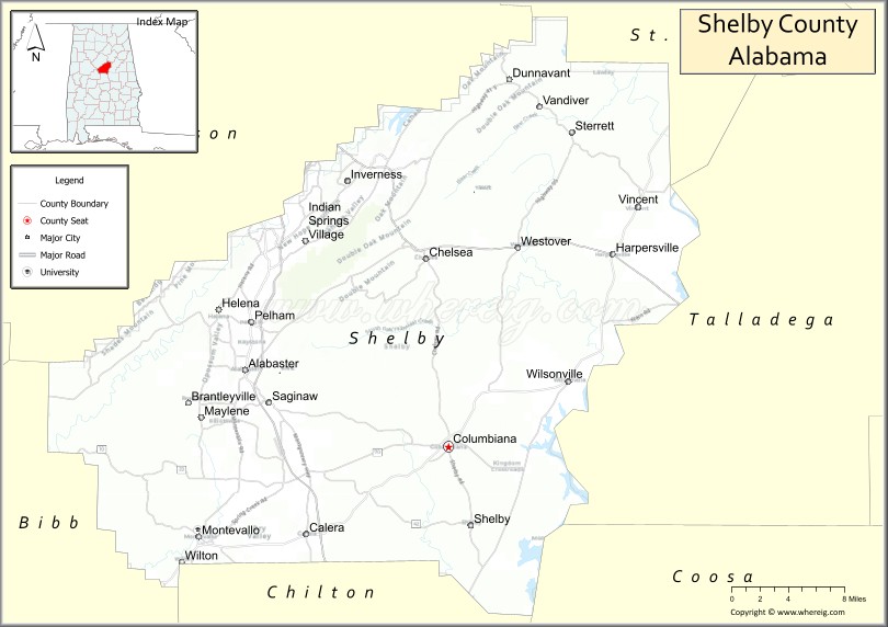
About Shelby County Map, Alabama: The map showing the county boundary, county seat, major cities, highways, water bodies and neighbouring counties.
Most Viewed Links
Map of Shelby County, Alabama
Shelby County is a county located in the U.S. state of Alabama. It`s county seat is Columbiana. As per 2020 census, the population of Shelby County was 226902 and population density of Shelby was 289.1square miles. According to the United States Census Bureau, the county has a total area of 784.93 sq mi (2,033 km2). Shelby County was established on 1818.
<Shelby County Facts
| Continent | North America |
| Country | United States |
| State | Alabama |
| County Seat | Columbiana |
| Largest City/Town | Alabaster |
| Established | February 7, 1818 |
| Total Area | 810 sq mi (2,098 sq km) |
| Land Area | 785 sq mi (2,033 sq km) |
| Water Area | 25 sq mi (65 sq km) |
| Population | 223,024 (Census 2020) |
| Population Density | 284 people per sq mi |
| Time Zone | Central Time Zone (CT) |
| Major Highways | Interstate 65, US 31, US 280, AL 25, AL 70, AL 119, AL 145 |
| Major Rivers | Coosa River, Cahaba River |
| Neighboring Counties | Jefferson County, St. Clair County, Talladega County, Coosa County, Chilton County, Bibb County |
| Famous For | Oak Mountain State Park, suburban growth, Cahaba River, and the Birmingham metropolitan area |
| Top Attractions | Oak Mountain State Park, American Village, Alabama Wildlife Center, Heart of Dixie Railroad Museum, and Aldridge Gardens |
| Official Website | Official Website |
About Shelby County, Alabama
Shelby County is located in central Alabama and was established in 1818. The county seat is Columbiana, while Alabaster is the largest city. As part of the Birmingham metropolitan area, Shelby County is one of Alabama's fastest-growing counties. The county features rolling hills, forests, lakes, and river valleys, with strong residential, commercial, and recreational development throughout the region.
Ctities and Towns in Shelby
| City Name | Type | Population (2020) | Pop. Density | Area |
|---|---|---|---|---|
| Birmingham | City | 200,733 | 1,374.2/sq mi (530.6/km2) | 146.07 sq mi (378.3 km2) |
| Hoover | City | 92,606 | 1,963.7/sq mi (758.2/km2) | 47.16 sq mi (122.1 km2) |
| Vestavia Hills | City | 39,102 | 2,014.5/sq mi (777.8/km2) | 19.41 sq mi (50.3 km2) |
| Leeds | City | 12,324 | 539.1/sq mi (208.2/km2) | 22.86 sq mi (59.2 km2) |
| Alabaster | City | 33,284 | 1,329.2/sq mi (513.2/km2) | 25.04 sq mi (64.9 km2) |
| Chelsea | City | 14,982 | 701.7/sq mi (270.9/km2) | 21.35 sq mi (55.3 km2) |
| Columbiana | City | 4,462 | 277.3/sq mi (107.1/km2) | 16.09 sq mi (41.7 km2) |
| Harpersville | Town | 1,614 | 77.9/sq mi (30.1/km2) | 20.73 sq mi (53.7 km2) |
| Indian Springs Village | Town | 2,481 | 652.9/sq mi (252.1/km2) | 3.8 sq mi (9.8 km2) |
| Montevallo | City | 7,229 | 574.2/sq mi (221.7/km2) | 12.59 sq mi (32.6 km2) |
| Pelham | City | 24,318 | 623.2/sq mi (240.6/km2) | 39.02 sq mi (101.1 km2) |
| Westover | City | 1,766 | 95.9/sq mi (37.0/km2) | 18.41 sq mi (47.7 km2) |
| Wilsonville | Town | 1,857 | 193.0/sq mi (74.5/km2) | 9.62 sq mi (24.9 km2) |
| Wilton | Town | 587 | 592.9/sq mi (228.9/km2) | 0.99 sq mi (2.6 km2) |
| Calera | City | 16,494 | 684.7/sq mi (264.4/km2) | 24.09 sq mi (62.4 km2) |
| Helena | City | 20,914 | 1,027.7/sq mi (396.8/km2) | 20.35 sq mi (52.7 km2) |
| Vincent | Town | 1,982 | 101.3/sq mi (39.1/km2) | 19.57 sq mi (50.7 km2) |
| Childersburg | City | 4,754 | 384.9/sq mi (148.6/km2) | 12.35 sq mi (32 km2) |
Best Golf Courses in Shelby County, Alabama
| Golf Course | Location | Latitude & Longitude |
|---|---|---|
| Ballantrae Golf Club | Pelham | 33.3132°N, 86.7563°W |
| Timberline Golf Club | Calera | 33.0972°N, 86.7348°W |
| Eagle Point Golf Club | Birmingham Area | 33.3958°N, 86.7069°W |
| Riverchase Country Club | Hoover | 33.3637°N, 86.7788°W |
| Greystone Golf & Country Club - Founders Course | Hoover Area | 33.4420°N, 86.6534°W |
| Greystone Golf & Country Club - Legacy Course | Hoover Area | 33.4409°N, 86.6502°W |
| Oak Mountain State Park Golf Course | Pelham | 33.3265°N, 86.7580°W |
| Heatherwood Golf & Country Club | Shelby County | 33.3638°N, 86.6322°W |
What are Major Roads and Highways in Shelby County
Major highways connect the county to nearby regions and cities.
- Interstate 65 - major north-south interstate connecting Shelby County with Birmingham and Montgomery
- US Highway 31 - historic route serving Alabaster, Pelham, Calera, and Columbiana
- US Highway 280 - major corridor connecting Chelsea with Birmingham and eastern Alabama
- Alabama State Route 119 - links Alabaster, Pelham, and Chelsea
- Alabama State Route 25 - serves Columbiana and southern communities
- Alabama State Route 145 - connects Shelby County with Jefferson County
- Alabama State Route 70 - crosses central portions of the county
Neighboring Counties of Shelby County
- Jefferson County (north)
- St. Clair County (northeast)
- Talladega County (east)
- Coosa County (southeast)
- Chilton County (south)
- Bibb County (west)
What are Top Attractions in Shelby County, Alabama
The county offers a mix of natural and cultural attractions.
| Main Sight Name | City | Famous For |
|---|---|---|
| Oak Mountain State Park | Pelham | Alabama's largest state park with hiking, camping, and lakes |
| American Village | Montevallo | Living history museum focused on American history |
| Heart of Dixie Railroad Museum | Calera | Historic train rides and railroad exhibits |
| Aldridge Gardens | Hoover | Botanical gardens and walking trails |
| Alabama Wildlife Center | Pelham | Wildlife rehabilitation and educational programs |
| University of Montevallo | Montevallo | Historic public university campus |
| Beeswax Creek Park | Columbiana Area | Boating and recreation on Lay Lake |
| Lay Lake | Wilsonville | Fishing, boating, and water recreation |
| Cahaba River National Wildlife Refuge | Westover Area | Rare Cahaba lily blooms and river ecosystems |
| Pelham Civic Complex | Pelham | Ice sports, events, and entertainment |
| Main Street Columbiana | Columbiana | Historic downtown district and local shops |
| Veterans Park | Alabaster | Sports facilities and family recreation |
| Chelsea Community Center | Chelsea | Community events and recreation |
| Old Mill Square | Montevallo | Historic district and local culture |
Distance from Shelby County to Nearby Cities
The following distances are measured by road (driving).
- Columbiana to Alabaster (Shelby County), Alabama - 16 mi (26 km)
- Columbiana to Pelham (Shelby County), Alabama - 19 mi (31 km)
- Columbiana to Chelsea (Shelby County), Alabama - 27 mi (43 km)
- Columbiana to Montevallo (Shelby County), Alabama - 16 mi (26 km)
- Columbiana to Calera (Shelby County), Alabama - 12 mi (19 km)
- Columbiana to Hoover (Jefferson County), Alabama - 25 mi (40 km)
- Columbiana to Birmingham (Jefferson County), Alabama - 33 mi (53 km)
- Columbiana to Pell City (St. Clair County), Alabama - 37 mi (60 km)
- Columbiana to Talladega (Talladega County), Alabama - 31 mi (50 km)
- Columbiana to Clanton (Chilton County), Alabama - 32 mi (51 km)
- Columbiana to Centreville (Bibb County), Alabama - 34 mi (55 km)
- Columbiana to Sylacauga (Talladega County), Alabama - 29 mi (47 km)
- Columbiana to Montgomery (Montgomery County), Alabama - 72 mi (116 km)
- Columbiana to Huntsville (Madison County), Alabama - 123 mi (198 km)
- Columbiana to Mobile (Mobile County), Alabama - 230 mi (370 km)
Nearest Airports
Nearest airport of Shelby is Charlotte Douglas International Airport (CLT).
References
- QuickFacts - U.S. Census Bureau
- United States Census Bureau
- United States Geological Survey (USGS)
- National Geodetic Survey
- Official County Website
- Autauga County Map
- Baldwin County Map
- Barbour County Map
- Bibb County Map
- Blount County Map
- Bullock County Map
- Butler County Map
- Calhoun County Map
- Chambers County Map
- Cherokee County Map
- Chilton County Map
- Choctaw County Map
- Clarke County Map
- Clay County Map
- Cleburne County Map
- Coffee County Map
- Colbert County Map
- Conecuh County Map
- Coosa County Map
- Covington County Map
- Crenshaw County Map
- Cullman County Map
- Dale County Map
- Dallas County Map
- DeKalb County Map
- Elmore County Map
- Escambia County Map
- Etowah County Map
- Fayette County Map
- Franklin County Map
- Geneva County Map
- Greene County Map
- Hale County Map
- Henry County Map
- Houston County Map
- Jackson County Map
- Jefferson County Map
- Lamar County Map
- Lauderdale County Map
- Lawrence County Map
- Lee County Map
- Limestone County Map
- Lowndes County Map
- Macon County Map
- Madison County Map
- Marengo County Map
- Marion County Map
- Marshall County Map
- Mobile County Map
- Monroe County Map
- Montgomery County Map
- Morgan County Map
- Perry County Map
- Pickens County Map
- Pike County Map
- Randolph County Map
- Russell County Map
- St Clair County Map
- Shelby County Map
- Sumter County Map
- Talladega County Map
- Tallapoosa County Map
- Tuscaloosa County Map
- Walker County Map
- Washington County Map
- Wilcox County Map
- Winston County Map
- Alabama Counties
- Alaska boroughs
- Arizona Counties
- Arkansas Counties
- California County Map
- Colorado Counties
- Connecticut Counties
- Delaware Counties
- Florida County Map
- Georgia County Map
- Hawaii Counties
- Idaho Counties
- Illinois Counties
- Indiana Counties
- Iowa Counties
- Kansas Counties
- Kentucky Counties
- Louisiana Counties
- Maine Counties
- Maryland Counties
- Massachusetts Counties
- Michigan County Map
- Minnesota Counties
- Mississippi Counties
- Missouri Counties
- Montana Counties
- Nebraska Counties
- Nevada Counties
- New York Counties
- New Hampshire Counties
- New Jersey Counties
- New Mexico Counties
- North Carolina Counties
- North Dakota Counties
- Ohio County Map
- Oklahoma Counties
- Oregon Counties
- Pennsylvania Counties
- Rhode Island Counties
- South Carolina Counties
- South Dakota Counties
- Map of Tennessee
- Texas County Map
- Utah Counties
- Vermont Counties
- Virginia Counties
- Washington Counties
- West Virginia Counties
- Wisconsin Counties
- Wyoming Counties