Map of Talladega County - Talladega County is a county located in the U.S. state of Alabama. Talladega County Map showing cities, highways, important places and water bodies. Get Where is Talladega County located in the map, major cities in Talladega county, population, areas, and places of interest.
Talladega County Map, Alabama
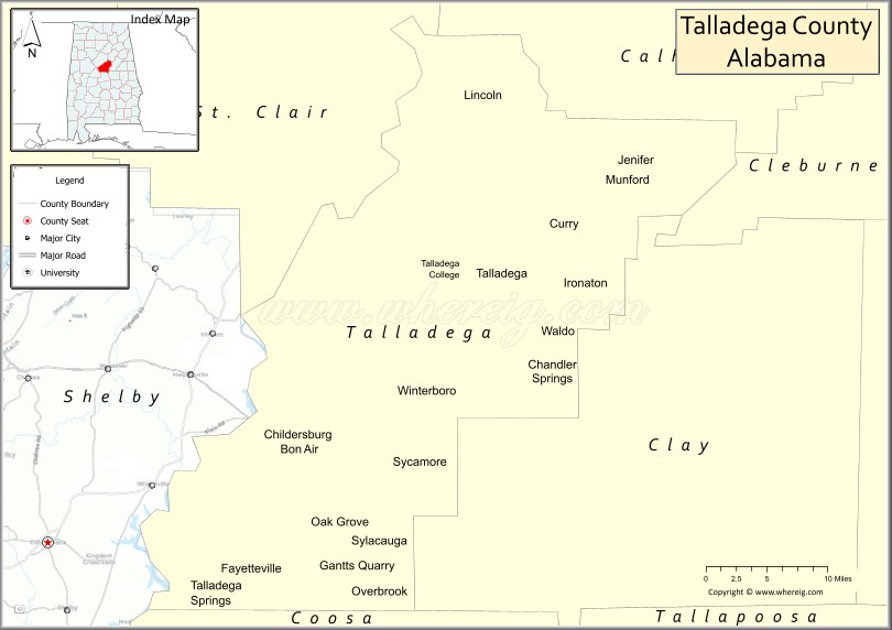
About Talladega County Map, Alabama: The map showing the county boundary, county seat, major cities, highways, water bodies and neighbouring counties.
Most Viewed Links
Map of Talladega County, Alabama
Talladega County is a county located in the U.S. state of Alabama. It`s county seat is Talladega. As per 2020 census, the population of Talladega County was 81524 and population density of Talladega was 110.6square miles. According to the United States Census Bureau, the county has a total area of 736.78 sq mi (1,908 km2). Talladega County was established on 1832.
Talladega County Facts
| Continent | North America |
| Country | United States |
| State | Alabama |
| County Seat | Talladega |
| Largest City/Town | Talladega |
| Established | December 18, 1832 |
| Total Area | 760 sq mi (1,968 sq km) |
| Land Area | 737 sq mi (1,909 sq km) |
| Water Area | 23 sq mi (60 sq km) |
| Population | 80,244 (Census 2020) |
| Population Density | 109 people per sq mi |
| Time Zone | Central Time Zone (CT) |
| Major Highways | Interstate 20, US 78, US 231, US 280, AL 21, AL 34, AL 77 |
| Major Rivers | Coosa River, Tallaseehatchee Creek |
| Neighboring Counties | Calhoun County, Cleburne County, Clay County, Coosa County, Shelby County, St. Clair County |
| Famous For | Talladega Superspeedway, Talladega National Forest, motorsports, and outdoor recreation |
| Top Attractions | Talladega Superspeedway, Talladega National Forest, Cheaha State Park, International Motorsports Hall of Fame, and DeSoto Caverns |
| Official Website | Official Website |
About Talladega County, Alabama
Talladega County is located in east-central Alabama and was established in 1832. The county seat and largest city is Talladega. The county is home to some of Alabama's most famous natural and recreational destinations, including Talladega National Forest and the world-renowned Talladega Superspeedway. Mountains, forests, lakes, and river valleys provide a diverse landscape that supports tourism, manufacturing, and outdoor recreation.
Cities and Towns in Talladega County, Alabama
| City/Town | Population (Census 2020) | Latitude & Longitude |
|---|---|---|
| Talladega (county seat) | 15,676 | 33.4359°N, 86.1058°W |
| Sylacauga | 12,008 | 33.1732°N, 86.2516°W |
| Lincoln | 6,845 | 33.5987°N, 86.1183°W |
| Childersburg | 4,717 | 33.2782°N, 86.3605°W |
| Munford | 1,292 | 33.5284°N, 85.9514°W |
| Oak Grove | 564 | 33.1887°N, 86.3076°W |
| Bon Air | 116 | 33.2657°N, 86.3357°W |
| Talladega Springs | 144 | 33.1239°N, 86.4469°W |
| Alpine (CDP) | 334 | 33.3318°N, 86.2089°W |
| Fayetteville (CDP) | 1,180 | 33.1479°N, 86.4049°W |
| Mignon (CDP) | 1,186 | 33.3544°N, 86.2618°W |
| Sycamore (CDP) | 441 | 33.2157°N, 86.3701°W |
| Winterboro (CDP) | 463 | 33.3541°N, 86.0728°W |
Best Golf Courses in Talladega County, Alabama
| Golf Course | Location | Latitude & Longitude |
|---|---|---|
| Talladega Country Club | Talladega | 33.4204°N, 86.0915°W |
| FarmLinks at Pursell Farms | Sylacauga | 33.1538°N, 86.3157°W |
| Cider Ridge Golf Club | Oxford Area | 33.6379°N, 85.9592°W |
| Coosa Pines Golf Club | Childersburg | 33.2744°N, 86.3427°W |
| Timber Ridge Golf Course | Talladega | 33.4523°N, 86.1142°W |
| Pinecrest Golf Course | Sylacauga | 33.1708°N, 86.2478°W |
What are Major Roads and Highways in Talladega County
Major highways connect the county to nearby regions and cities.
- Interstate 20 - major east-west interstate connecting Talladega County with Birmingham and Atlanta
- US Highway 78 - regional route serving Lincoln and eastern communities
- US Highway 231 - north-south corridor connecting Sylacauga with Pell City and Montgomery
- US Highway 280 - major route through Childersburg and western portions of the county
- Alabama State Route 21 - connects Talladega, Sylacauga, and Munford
- Alabama State Route 34 - serves Childersburg and nearby communities
- Alabama State Route 77 - links Talladega with Lincoln and Gadsden-area routes
Neighboring Counties of Talladega County
- St. Clair County (northwest)
- Calhoun County (north)
- Cleburne County (northeast)
- Clay County (east)
- Coosa County (south)
- Shelby County (west)
What are Top Attractions in Talladega County, Alabama
The county offers a mix of natural and cultural attractions.
| Main Sight Name | City | Famous For |
|---|---|---|
| Talladega Superspeedway | Lincoln | NASCAR racing and major motorsports events |
| International Motorsports Hall of Fame | Lincoln | Motorsports history and exhibits |
| Talladega National Forest | Countywide | Hiking, camping, and scenic mountain landscapes |
| Cheaha State Park | Eastern Talladega County | Highest point in Alabama and panoramic views |
| DeSoto Caverns | Childersburg | Cave tours and family attractions |
| Pursell Farms | Sylacauga | Resort destination and championship golf |
| Comer Museum and Arts Center | Sylacauga | Regional history and art exhibits |
| Talladega Historic Courthouse Square | Talladega | Historic architecture and downtown attractions |
| Kymulga Grist Mill Park | Childersburg Area | Historic covered bridge and mill |
| Logan Martin Lake Access Areas | Lincoln | Boating and fishing recreation |
| Jemison-Carnegie Heritage Hall | Talladega | Local history museum |
| Munford Historic Area | Munford | Small-town heritage and community events |
| Lake Howard | Sylacauga | Fishing and outdoor recreation |
| Talladega Walk of Fame | Talladega | Recognition of racing legends |
Distance from Talladega County to Nearby Cities
The following distances are measured by road (driving).
- Talladega to Lincoln (Talladega County), Alabama - 15 mi (24 km)
- Talladega to Munford (Talladega County), Alabama - 10 mi (16 km)
- Talladega to Childersburg (Talladega County), Alabama - 21 mi (34 km)
- Talladega to Sylacauga (Talladega County), Alabama - 25 mi (40 km)
- Talladega to Pell City (St. Clair County), Alabama - 24 mi (39 km)
- Talladega to Anniston (Calhoun County), Alabama - 24 mi (39 km)
- Talladega to Heflin (Cleburne County), Alabama - 35 mi (56 km)
- Talladega to Ashland (Clay County), Alabama - 30 mi (48 km)
- Talladega to Columbiana (Shelby County), Alabama - 32 mi (51 km)
- Talladega to Rockford (Coosa County), Alabama - 37 mi (60 km)
- Talladega to Birmingham (Jefferson County), Alabama - 53 mi (85 km)
- Talladega to Gadsden (Etowah County), Alabama - 48 mi (77 km)
- Talladega to Montgomery (Montgomery County), Alabama - 96 mi (154 km)
- Talladega to Atlanta, Georgia - 122 mi (196 km)
- Talladega to Huntsville (Madison County), Alabama - 123 mi (198 km)
Nearest Airports
Nearest airport of Talladega is Talladega Municipal Airport.
References
- QuickFacts - U.S. Census Bureau
- United States Census Bureau
- United States Geological Survey (USGS)
- National Geodetic Survey
- Official County Website
- Autauga County Map
- Baldwin County Map
- Barbour County Map
- Bibb County Map
- Blount County Map
- Bullock County Map
- Butler County Map
- Calhoun County Map
- Chambers County Map
- Cherokee County Map
- Chilton County Map
- Choctaw County Map
- Clarke County Map
- Clay County Map
- Cleburne County Map
- Coffee County Map
- Colbert County Map
- Conecuh County Map
- Coosa County Map
- Covington County Map
- Crenshaw County Map
- Cullman County Map
- Dale County Map
- Dallas County Map
- DeKalb County Map
- Elmore County Map
- Escambia County Map
- Etowah County Map
- Fayette County Map
- Franklin County Map
- Geneva County Map
- Greene County Map
- Hale County Map
- Henry County Map
- Houston County Map
- Jackson County Map
- Jefferson County Map
- Lamar County Map
- Lauderdale County Map
- Lawrence County Map
- Lee County Map
- Limestone County Map
- Lowndes County Map
- Macon County Map
- Madison County Map
- Marengo County Map
- Marion County Map
- Marshall County Map
- Mobile County Map
- Monroe County Map
- Montgomery County Map
- Morgan County Map
- Perry County Map
- Pickens County Map
- Pike County Map
- Randolph County Map
- Russell County Map
- St Clair County Map
- Shelby County Map
- Sumter County Map
- Talladega County Map
- Tallapoosa County Map
- Tuscaloosa County Map
- Walker County Map
- Washington County Map
- Wilcox County Map
- Winston County Map
- Alabama Counties
- Alaska boroughs
- Arizona Counties
- Arkansas Counties
- California County Map
- Colorado Counties
- Connecticut Counties
- Delaware Counties
- Florida County Map
- Georgia County Map
- Hawaii Counties
- Idaho Counties
- Illinois Counties
- Indiana Counties
- Iowa Counties
- Kansas Counties
- Kentucky Counties
- Louisiana Counties
- Maine Counties
- Maryland Counties
- Massachusetts Counties
- Michigan County Map
- Minnesota Counties
- Mississippi Counties
- Missouri Counties
- Montana Counties
- Nebraska Counties
- Nevada Counties
- New York Counties
- New Hampshire Counties
- New Jersey Counties
- New Mexico Counties
- North Carolina Counties
- North Dakota Counties
- Ohio County Map
- Oklahoma Counties
- Oregon Counties
- Pennsylvania Counties
- Rhode Island Counties
- South Carolina Counties
- South Dakota Counties
- Map of Tennessee
- Texas County Map
- Utah Counties
- Vermont Counties
- Virginia Counties
- Washington Counties
- West Virginia Counties
- Wisconsin Counties
- Wyoming Counties