Map of Cherokee County - Cherokee County is a county located in the U.S. state of Alabama. Cherokee County Map showing cities, highways, important places and water bodies. Get Where is Cherokee County located in the map, major cities in Cherokee county, population, areas, and places of interest.
Cherokee County Map, Alabama
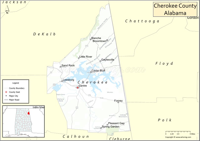
About Cherokee County Map, Alabama: The map showing the county boundary, county seat, major cities, highways, water bodies and neighbouring counties.
Most Viewed Links
Map of Cherokee County, Alabama
Cherokee County is a county located in the U.S. state of Alabama. It`s county seat is Centre. As per 2020 census, the population of Cherokee County was 24996 and population density of Cherokee was 45.1square miles. According to the United States Census Bureau, the county has a total area of 553.70 sq mi (1,434 km2). Cherokee County was established on 1836.
Cherokee County Facts
| County Info | Facts |
|---|---|
| County | Cherokee County |
| County Seat | Centre |
| State | Alabama |
| Country | United States |
| FIPS code | 19 |
| Established | 1836 |
| Area | 553.70 sq mi (1,434 km2) |
| Population | 24996 |
| Density | 45.1 |
| Formed / Origin | Cherokee territory |
Ctities and Towns in Cherokee
| City Name | Type | Population (2020) | Pop. Density | Area |
|---|---|---|---|---|
| Piedmont | City | 4,787 | 488.0/sq mi (188.4/km2) | 9.81 sq mi (25.4 km2) |
| Cedar Bluff | Town | 1,845 | 363.9/sq mi (140.5/km2) | 5.07 sq mi (13.1 km2) |
| Centre | City | 3,587 | 313.5/sq mi (121.1/km2) | 11.44 sq mi (29.6 km2) |
| Gaylesville | Town | 170 | 500.0/sq mi (193.1/km2) | 0.34 sq mi (0.88 km2) |
| Leesburg | Town | 911 | 141.9/sq mi (54.8/km2) | 6.42 sq mi (16.6 km2) |
| Sand Rock | Town | 591 | 135.6/sq mi (52.3/km2) | 4.36 sq mi (11.3 km2) |
| Collinsville | Town | 2,059 | 525.3/sq mi (202.8/km2) | 3.92 sq mi (10.2 km2) |
Places to Visit in Cherokee
Top places to visit in london includes Museum of the Cherokee Indian,Oconaluftee Island Park,Mingo Falls,Great Smoky Mountains National,Oconaluftee Indian Village,Oconaluftee Visitor Center,Mountain Farm Museum,Cherokee Rapids River Tubing,Cherokee Welcome Center,Soco Falls,Unto These Hills Ticket Office,Unto These Hills, Outdoor Drama,Cherokee Veterans Park,End of the Trail Riding Stables,Oconaluftee River Trail,Mingus Creek Trail,Cherokee Bear Zoo,Mingus Mill,Oconaluftee Indian Village.
Highways in Cherokee
US Highway 72.
Nearest Airports
Nearest airport of Cherokee is Northwest Alabama Regional Airport.
- Autauga County Map
- Baldwin County Map
- Barbour County Map
- Bibb County Map
- Blount County Map
- Bullock County Map
- Butler County Map
- Calhoun County Map
- Chambers County Map
- Cherokee County Map
- Chilton County Map
- Choctaw County Map
- Clarke County Map
- Clay County Map
- Cleburne County Map
- Coffee County Map
- Colbert County Map
- Conecuh County Map
- Coosa County Map
- Covington County Map
- Crenshaw County Map
- Cullman County Map
- Dale County Map
- Dallas County Map
- DeKalb County Map
- Elmore County Map
- Escambia County Map
- Etowah County Map
- Fayette County Map
- Franklin County Map
- Geneva County Map
- Greene County Map
- Hale County Map
- Henry County Map
- Houston County Map
- Jackson County Map
- Jefferson County Map
- Lamar County Map
- Lauderdale County Map
- Lawrence County Map
- Lee County Map
- Limestone County Map
- Lowndes County Map
- Macon County Map
- Madison County Map
- Marengo County Map
- Marion County Map
- Marshall County Map
- Mobile County Map
- Monroe County Map
- Montgomery County Map
- Morgan County Map
- Perry County Map
- Pickens County Map
- Pike County Map
- Randolph County Map
- Russell County Map
- St Clair County Map
- Shelby County Map
- Sumter County Map
- Talladega County Map
- Tallapoosa County Map
- Tuscaloosa County Map
- Walker County Map
- Washington County Map
- Wilcox County Map
- Winston County Map
- Alabama Counties
- Alaska boroughs
- Arizona Counties
- Arkansas Counties
- California County Map
- Colorado Counties
- Connecticut Counties
- Delaware Counties
- Florida County Map
- Georgia County Map
- Hawaii Counties
- Idaho Counties
- Illinois Counties
- Indiana Counties
- Iowa Counties
- Kansas Counties
- Kentucky Counties
- Louisiana Counties
- Maine Counties
- Maryland Counties
- Massachusetts Counties
- Michigan County Map
- Minnesota Counties
- Mississippi Counties
- Missouri Counties
- Montana Counties
- Nebraska Counties
- New Hampshire Counties
- New Jersey Counties
- New Mexico Counties
- North Carolina Counties
- North Dakota Counties
- Oklahoma Counties
- Oregon Counties
- Pennsylvania Counties
- Rhode Island Counties
- South Carolina Counties
- South Dakota Counties
- Map of Tennessee
- Texas County Map
- Utah Counties
- Vermont Counties
- Virginia Counties
- Washington Counties
- West Virginia Counties
- Wisconsin Counties
- Wyoming Counties
- Nevada Counties
- New York Counties
- Ohio County Map