Map of Conecuh County - Conecuh County is a county located in the U.S. state of Alabama. Conecuh County Map showing cities, highways, important places and water bodies. Get Where is Conecuh County located in the map, major cities in Conecuh county, population, areas, and places of interest.
Conecuh County Map, Alabama
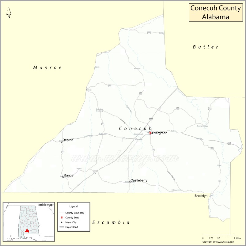
About Conecuh County Map, Alabama: The map showing the county boundary, county seat, major cities, highways, water bodies and neighbouring counties.
Most Viewed Links
Map of Conecuh County, Alabama
Conecuh County is a county located in the U.S. state of Alabama. It`s county seat is Evergreen. As per 2020 census, the population of Conecuh County was 11328 and population density of Conecuh was 13.3square miles. According to the United States Census Bureau, the county has a total area of 850.16 sq mi (2,202 km2). Conecuh County was established on 1818.
Conecuh County Facts
| Continent | North America |
| Country | United States |
| State | Alabama |
| County Seat | Evergreen |
| Largest City/Town | Evergreen |
| Established | February 13, 1818 |
| Total Area | 853 sq mi (2,209 sq km) |
| Land Area | 850 sq mi (2,202 sq km) |
| Water Area | 3 sq mi (8 sq km) |
| Population | 11,597 (Census 2020) |
| Population Density | 14 people per sq mi |
| Time Zone | Central Time Zone (CT) |
| Major Highways | Interstate 65, US 31, US 84, AL 41, AL 83 |
| Major Rivers | Conecuh River, Sepulga River |
| Neighboring Counties | Butler County, Covington County, Escambia County, Monroe County, Wilcox County |
| Famous For | Conecuh Sausage, forests, hunting lands, and southern Alabama heritage |
| Top Attractions | Conecuh National Forest, Conecuh Sausage Gift Shop, Evergreen Historic District, Sepulga River, Owassa Lake |
| Official Website | Official Website |
About Conecuh County, Alabama
Conecuh County is located in south-central Alabama and was established in 1818. The county seat and largest city is Evergreen. The county is known for its vast pine forests, outdoor recreation opportunities, and the nationally recognized Conecuh Sausage brand, which has become one of Alabama's most famous food products.
Cities and Towns in Conecuh County, Alabama
| City/Town | Population (Census 2020) | Latitude & Longitude |
|---|---|---|
| Evergreen (county seat) | 3,544 | 31.4335°N, 86.9561°W |
| Castleberry | 486 | 31.2988°N, 87.0277°W |
| Repton | 280 | 31.4118°N, 87.2361°W |
| Range (CDP) | 113 | 31.4709°N, 87.2624°W |
| Belleville (CDP) | 172 | 31.5474°N, 86.9097°W |
Best Golf Courses in Conecuh County, Alabama
| Golf Course | Location | Latitude & Longitude |
|---|---|---|
| Evergreen Golf Club | Evergreen | 31.4369°N, 86.9446°W |
| Evergreen Country Club | Evergreen | 31.4407°N, 86.9518°W |
What are Major Roads and Highways in Conecuh County
Major highways connect the county to nearby regions and cities.
- Interstate 65 - major north-south interstate connecting Mobile, Evergreen, Montgomery, and Birmingham
- US Highway 31 - historic route paralleling Interstate 65 through Evergreen and Castleberry
- US Highway 84 - east-west route connecting Evergreen with Monroeville and Opp
- Alabama State Route 41 - connects the county with Brewton and Crenshaw County
- Alabama State Route 83 - serves eastern and northern parts of the county
Neighboring Counties of Conecuh County
- Butler County (north)
- Wilcox County (northwest)
- Monroe County (west)
- Escambia County (south)
- Covington County (east)
What are Top Attractions in Conecuh County, Alabama
The county offers a mix of natural and cultural attractions.
| Main Sight Name | City | Famous For |
|---|---|---|
| Conecuh Sausage Gift Shop | Evergreen | Famous Alabama sausage products and local food heritage |
| Evergreen Historic District | Evergreen | Historic buildings and southern architecture |
| Conecuh National Forest | Southern County | Hiking, wildlife viewing, camping, and recreation |
| Sepulga River | Countywide | Fishing, paddling, and natural scenery |
| Conecuh River | Countywide | River recreation and wildlife habitats |
| Owassa Lake Recreation Area | Owassa Area | Fishing and outdoor recreation |
| Castleberry Historic Area | Castleberry | Railroad heritage and local history |
| Evergreen City Park | Evergreen | Community events and outdoor activities |
| Conecuh County Courthouse | Evergreen | Historic county landmark |
| Repton Community Heritage Area | Repton | Small-town Alabama history |
| Blue Springs Wildlife Area | Eastern County | Nature viewing and outdoor recreation |
| Pine Forest Scenic Drives | Countywide | Beautiful rural landscapes and forests |
Distance from Conecuh County to Nearby Cities
The following distances are measured by road (driving).
- Evergreen to Castleberry (Conecuh County), Alabama - 9 mi (14 km)
- Evergreen to Repton (Conecuh County), Alabama - 18 mi (29 km)
- Evergreen to Monroeville (Monroe County), Alabama - 33 mi (53 km)
- Evergreen to Brewton (Escambia County), Alabama - 39 mi (63 km)
- Evergreen to Opp (Covington County), Alabama - 34 mi (55 km)
- Evergreen to Andalusia (Covington County), Alabama - 48 mi (77 km)
- Evergreen to Greenville (Butler County), Alabama - 37 mi (60 km)
- Evergreen to Atmore (Escambia County), Alabama - 58 mi (93 km)
- Evergreen to Mobile (Mobile County), Alabama - 94 mi (151 km)
- Evergreen to Montgomery (Montgomery County), Alabama - 86 mi (138 km)
- Evergreen to Selma (Dallas County), Alabama - 87 mi (140 km)
- Evergreen to Pensacola, Florida - 84 mi (135 km)
- Evergreen to Birmingham (Jefferson County), Alabama - 146 mi (235 km)
References
- QuickFacts - U.S. Census Bureau
- United States Census Bureau
- United States Geological Survey (USGS)
- National Geodetic Survey
- Official County Website
- Autauga County Map
- Baldwin County Map
- Barbour County Map
- Bibb County Map
- Blount County Map
- Bullock County Map
- Butler County Map
- Calhoun County Map
- Chambers County Map
- Cherokee County Map
- Chilton County Map
- Choctaw County Map
- Clarke County Map
- Clay County Map
- Cleburne County Map
- Coffee County Map
- Colbert County Map
- Conecuh County Map
- Coosa County Map
- Covington County Map
- Crenshaw County Map
- Cullman County Map
- Dale County Map
- Dallas County Map
- DeKalb County Map
- Elmore County Map
- Escambia County Map
- Etowah County Map
- Fayette County Map
- Franklin County Map
- Geneva County Map
- Greene County Map
- Hale County Map
- Henry County Map
- Houston County Map
- Jackson County Map
- Jefferson County Map
- Lamar County Map
- Lauderdale County Map
- Lawrence County Map
- Lee County Map
- Limestone County Map
- Lowndes County Map
- Macon County Map
- Madison County Map
- Marengo County Map
- Marion County Map
- Marshall County Map
- Mobile County Map
- Monroe County Map
- Montgomery County Map
- Morgan County Map
- Perry County Map
- Pickens County Map
- Pike County Map
- Randolph County Map
- Russell County Map
- St Clair County Map
- Shelby County Map
- Sumter County Map
- Talladega County Map
- Tallapoosa County Map
- Tuscaloosa County Map
- Walker County Map
- Washington County Map
- Wilcox County Map
- Winston County Map
- Alabama Counties
- Alaska boroughs
- Arizona Counties
- Arkansas Counties
- California County Map
- Colorado Counties
- Connecticut Counties
- Delaware Counties
- Florida County Map
- Georgia County Map
- Hawaii Counties
- Idaho Counties
- Illinois Counties
- Indiana Counties
- Iowa Counties
- Kansas Counties
- Kentucky Counties
- Louisiana Counties
- Maine Counties
- Maryland Counties
- Massachusetts Counties
- Michigan County Map
- Minnesota Counties
- Mississippi Counties
- Missouri Counties
- Montana Counties
- Nebraska Counties
- Nevada Counties
- New York Counties
- New Hampshire Counties
- New Jersey Counties
- New Mexico Counties
- North Carolina Counties
- North Dakota Counties
- Ohio County Map
- Oklahoma Counties
- Oregon Counties
- Pennsylvania Counties
- Rhode Island Counties
- South Carolina Counties
- South Dakota Counties
- Map of Tennessee
- Texas County Map
- Utah Counties
- Vermont Counties
- Virginia Counties
- Washington Counties
- West Virginia Counties
- Wisconsin Counties
- Wyoming Counties