Map of Houston County - Houston County is a county located in the U.S. state of Alabama. Houston County Map showing cities, highways, important places and water bodies. Get Where is Houston County located in the map, major cities in Houston county, population, areas, and places of interest.
Houston County Map, Alabama
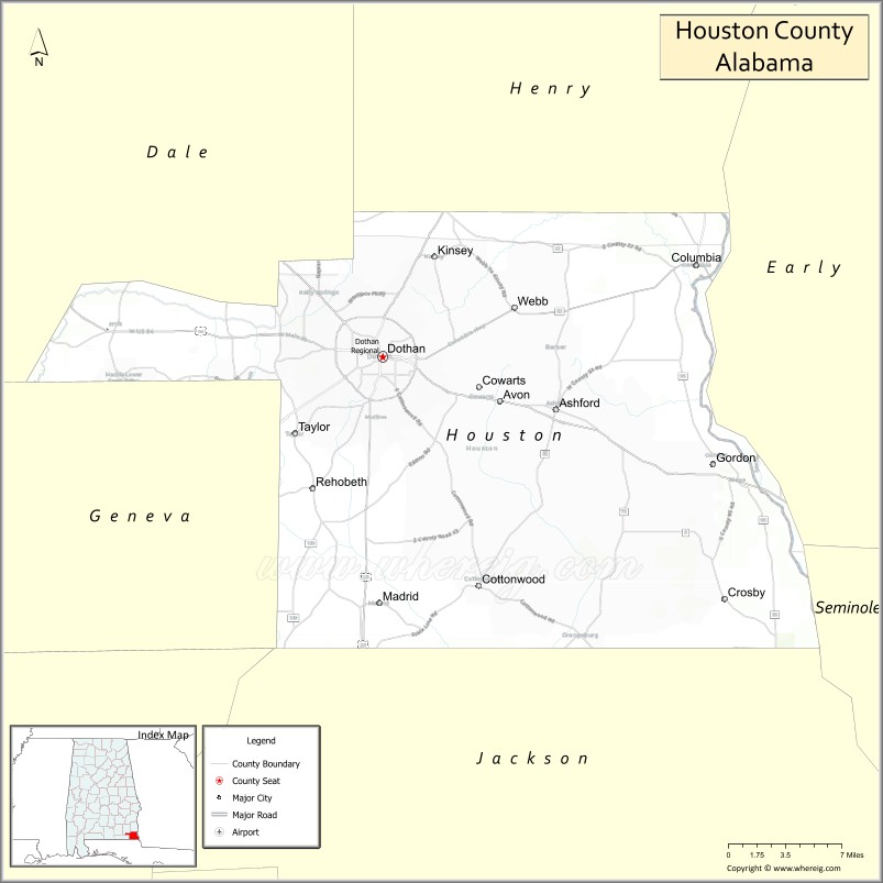
About Houston County Map, Alabama: The map showing the county boundary, county seat, major cities, highways, water bodies and neighbouring counties.
Most Viewed Links
Map of Houston County, Alabama
Houston County is a county located in the U.S. state of Alabama. It`s county seat is Dothan. As per 2020 census, the population of Houston County was 107458 and population density of Houston was 185.3square miles. According to the United States Census Bureau, the county has a total area of 579.82 sq mi (1,502 km2). Houston County was established on 1903.
Houston County Facts
| Continent | North America |
| Country | United States |
| State | Alabama |
| County Seat | Dothan |
| Largest City/Town | Dothan |
| Established | February 9, 1903 |
| Total Area | 582 sq mi (1,507 sq km) |
| Land Area | 580 sq mi (1,502 sq km) |
| Water Area | 2 sq mi (5 sq km) |
| Population | 107,202 (Census 2020) |
| Population Density | 185 people per sq mi |
| Time Zone | Central Time Zone (CT) |
| Major Highways | US 84, US 231, US 431, AL 52, AL 53, Ross Clark Circle |
| Major Rivers | Chattahoochee River, Choctawhatchee River, Little Choctawhatchee River |
| Neighboring Counties | Dale County, Henry County, Geneva County, Jackson County (FL), Holmes County (FL), Early County (GA) |
| Famous For | Dothan, the National Peanut Festival, healthcare services, and the Wiregrass region |
| Top Attractions | Landmark Park, Dothan Area Botanical Gardens, National Peanut Festival Fairgrounds, Wiregrass Museum of Art, Adventureland |
| Official Website | Official Website |
About Houston County, Alabama
Houston County is located in southeastern Alabama in the Wiregrass region and was established in 1903. The county seat and largest city is Dothan. Houston County is Alabama's youngest county and serves as a major commercial, healthcare, educational, and transportation hub for southeast Alabama, southwest Georgia, and the Florida Panhandle. The county is widely known for peanut production and the annual National Peanut Festival.
Cities and Towns in Houston County, Alabama
| City/Town | Population (Census 2020) | Latitude & Longitude |
|---|---|---|
| Dothan (county seat) | 71,072 | 31.2232°N, 85.3905°W |
| Ashford | 2,254 | 31.1824°N, 85.2360°W |
| Cottonwood | 1,244 | 31.0488°N, 85.3066°W |
| Gordon | 322 | 31.0366°N, 85.0960°W |
| Kinsey | 2,198 | 31.2991°N, 85.3441°W |
| Madrid | 315 | 31.0361°N, 85.5149°W |
| Pansey (CDP) | 848 | 31.1193°N, 85.1841°W |
| Taylor | 2,399 | 31.1660°N, 85.4680°W |
| Rehobeth | 1,917 | 31.1274°N, 85.4485°W |
| Webb | 1,342 | 31.2607°N, 85.2730°W |
| Columbia (partly in Houston County) | 740 | 31.2924°N, 85.1110°W |
| Cowarts | 1,871 | 31.2005°N, 85.3049°W |
Best Golf Courses in Houston County, Alabama
| Golf Course | Location | Latitude & Longitude |
|---|---|---|
| Dothan Country Club | Dothan | 31.2391°N, 85.3587°W |
| Highland Oaks Golf Course - Highlands Course | Dothan | 31.2247°N, 85.4290°W |
| Highland Oaks Golf Course - Marshwood Course | Dothan | 31.2247°N, 85.4290°W |
| Highland Oaks Golf Course - Short Course | Dothan | 31.2247°N, 85.4290°W |
| Roundabout Plantation Golf Course | Cowarts | 31.1924°N, 85.2968°W |
| Wiregrass Golf Club | Dothan | 31.1708°N, 85.4297°W |
| Forever Wild Trails & Golf Practice Facility | Dothan | 31.2370°N, 85.3976°W |
What are Major Roads and Highways in Houston County
Major highways connect the county to nearby regions and cities.
- US Highway 231 - major north-south route connecting Dothan with Montgomery and Panama City, Florida
- US Highway 84 - east-west corridor connecting Dothan with Enterprise and Bainbridge, Georgia
- US Highway 431 - connects Dothan with Eufaula and Florida communities
- Alabama State Route 52 - major route linking Dothan with Geneva County and Chattahoochee, Florida
- Alabama State Route 53 - serves eastern Houston County communities
- Ross Clark Circle - major bypass route surrounding Dothan and connecting all major highways
Neighboring Counties of Houston County
- Dale County (northwest)
- Henry County (north)
- Early County, Georgia (east)
- Jackson County, Florida (south)
- Holmes County, Florida (southwest)
- Geneva County (west)
What are Top Attractions in Houston County, Alabama
The county offers a mix of natural and cultural attractions.
| Main Sight Name | City | Famous For |
|---|---|---|
| Landmark Park | Dothan | Living history farm, planetarium, and nature trails |
| Dothan Area Botanical Gardens | Dothan | Beautiful themed gardens and walking paths |
| National Peanut Festival Fairgrounds | Dothan | Home of the annual National Peanut Festival |
| Wiregrass Museum of Art | Dothan | Regional art exhibits and cultural events |
| Adventureland Theme Park | Dothan | Family entertainment and mini golf |
| Murals of the Wiregrass | Dothan | Public art celebrating local history |
| Westgate Park | Dothan | Major sports complex and recreation area |
| Wiregrass Commons Mall Area | Dothan | Shopping and dining destination |
| Forever Wild Trails | Dothan | Mountain biking and hiking trails |
| Peanut Monument Trail | Dothan | Iconic peanut-themed public sculptures |
| Cherry Street AME Church | Dothan | Historic Civil Rights landmark |
| Chattahoochee River Access Areas | Eastern County | Fishing and outdoor recreation |
Distance from Houston County to Nearby Cities
The following distances are measured by road (driving).
- Dothan to Ashford (Houston County), Alabama - 10 mi (16 km)
- Dothan to Cottonwood (Houston County), Alabama - 14 mi (23 km)
- Dothan to Cowarts (Houston County), Alabama - 5 mi (8 km)
- Dothan to Rehobeth (Houston County), Alabama - 9 mi (14 km)
- Dothan to Ozark (Dale County), Alabama - 21 mi (34 km)
- Dothan to Abbeville (Henry County), Alabama - 28 mi (45 km)
- Dothan to Geneva (Geneva County), Alabama - 29 mi (47 km)
- Dothan to Enterprise (Coffee County), Alabama - 31 mi (50 km)
- Dothan to Eufaula (Barbour County), Alabama - 46 mi (74 km)
- Dothan to Marianna, Florida - 32 mi (52 km)
- Dothan to Panama City, Florida - 82 mi (132 km)
- Dothan to Tallahassee, Florida - 99 mi (159 km)
- Dothan to Montgomery (Montgomery County), Alabama - 104 mi (167 km)
- Dothan to Columbus, Georgia - 97 mi (156 km)
- Dothan to Auburn (Lee County), Alabama - 88 mi (142 km)
Nearest Airports
Nearest airport of Houston is George Bush Intercontinental Airport.
References
- QuickFacts - U.S. Census Bureau
- United States Census Bureau
- United States Geological Survey (USGS)
- National Geodetic Survey
- Official County Website
- Autauga County Map
- Baldwin County Map
- Barbour County Map
- Bibb County Map
- Blount County Map
- Bullock County Map
- Butler County Map
- Calhoun County Map
- Chambers County Map
- Cherokee County Map
- Chilton County Map
- Choctaw County Map
- Clarke County Map
- Clay County Map
- Cleburne County Map
- Coffee County Map
- Colbert County Map
- Conecuh County Map
- Coosa County Map
- Covington County Map
- Crenshaw County Map
- Cullman County Map
- Dale County Map
- Dallas County Map
- DeKalb County Map
- Elmore County Map
- Escambia County Map
- Etowah County Map
- Fayette County Map
- Franklin County Map
- Geneva County Map
- Greene County Map
- Hale County Map
- Henry County Map
- Houston County Map
- Jackson County Map
- Jefferson County Map
- Lamar County Map
- Lauderdale County Map
- Lawrence County Map
- Lee County Map
- Limestone County Map
- Lowndes County Map
- Macon County Map
- Madison County Map
- Marengo County Map
- Marion County Map
- Marshall County Map
- Mobile County Map
- Monroe County Map
- Montgomery County Map
- Morgan County Map
- Perry County Map
- Pickens County Map
- Pike County Map
- Randolph County Map
- Russell County Map
- St Clair County Map
- Shelby County Map
- Sumter County Map
- Talladega County Map
- Tallapoosa County Map
- Tuscaloosa County Map
- Walker County Map
- Washington County Map
- Wilcox County Map
- Winston County Map
- Alabama Counties
- Alaska boroughs
- Arizona Counties
- Arkansas Counties
- California County Map
- Colorado Counties
- Connecticut Counties
- Delaware Counties
- Florida County Map
- Georgia County Map
- Hawaii Counties
- Idaho Counties
- Illinois Counties
- Indiana Counties
- Iowa Counties
- Kansas Counties
- Kentucky Counties
- Louisiana Counties
- Maine Counties
- Maryland Counties
- Massachusetts Counties
- Michigan County Map
- Minnesota Counties
- Mississippi Counties
- Missouri Counties
- Montana Counties
- Nebraska Counties
- Nevada Counties
- New York Counties
- New Hampshire Counties
- New Jersey Counties
- New Mexico Counties
- North Carolina Counties
- North Dakota Counties
- Ohio County Map
- Oklahoma Counties
- Oregon Counties
- Pennsylvania Counties
- Rhode Island Counties
- South Carolina Counties
- South Dakota Counties
- Map of Tennessee
- Texas County Map
- Utah Counties
- Vermont Counties
- Virginia Counties
- Washington Counties
- West Virginia Counties
- Wisconsin Counties
- Wyoming Counties