Map of Jefferson County - Jefferson County is a county located in the U.S. state of Alabama. Jefferson County Map showing cities, highways, important places and water bodies. Get Where is Jefferson County located in the map, major cities in Jefferson county, population, areas, and places of interest.
Jefferson County Map, Alabama
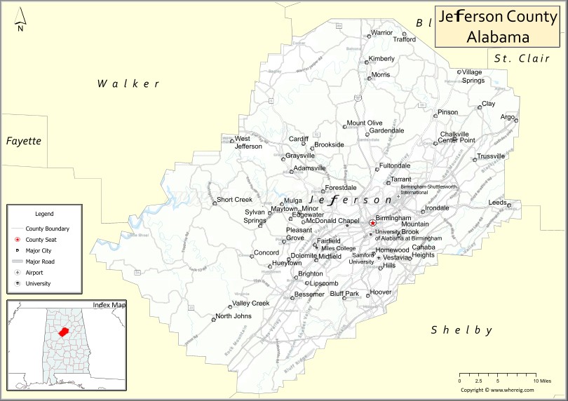
About Jefferson County Map, Alabama: The map showing the county boundary, county seat, major cities, highways, water bodies and neighbouring counties.
Most Viewed Links
Map of Jefferson County, Alabama
Jefferson County is a county located in the U.S. state of Alabama. It`s county seat is Birmingham. As per 2020 census, the population of Jefferson County was 667820 and population density of Jefferson was 600.9square miles. According to the United States Census Bureau, the county has a total area of 1,111.28 sq mi (2,878 km2). Jefferson County was established on 1819.
Jefferson County Facts
| Continent | North America |
| Country | United States |
| State | Alabama |
| County Seat | Birmingham |
| Largest City/Town | Birmingham |
| Established | December 13, 1819 |
| Total Area | 1,124 sq mi (2,911 sq km) |
| Land Area | 1,111 sq mi (2,877 sq km) |
| Water Area | 13 sq mi (34 sq km) |
| Population | 674,721 (Census 2020) |
| Population Density | 607 people per sq mi |
| Time Zone | Central Time Zone (CT) |
| Major Highways | Interstate 20, Interstate 22, Interstate 59, Interstate 65, Interstate 459, Interstate 459, US 11, US 31, US 78, US 280 |
| Major Rivers | Black Warrior River, Cahaba River, Locust Fork |
| Neighboring Counties | Walker County, Blount County, St. Clair County, Shelby County, Bibb County, Tuscaloosa County |
| Famous For | Birmingham, Civil Rights history, iron and steel industry, healthcare, and higher education |
| Top Attractions | Birmingham Civil Rights Institute, Vulcan Park, Birmingham Zoo, Railroad Park, Barber Motorsports Park |
| Official Website | Official Website |
About Jefferson County, Alabama
Jefferson County is located in north-central Alabama and was established in 1819. The county seat and largest city is Birmingham. It is the most populous county in Alabama and serves as the state's leading center for business, healthcare, education, finance, and transportation. The county is situated within the Appalachian foothills and is known for its rich industrial history, Civil Rights landmarks, and diverse cultural attractions.
Cities and Towns in Jefferson County, Alabama
| City/Town | Population (Census 2020) | Latitude & Longitude |
|---|---|---|
| Birmingham (county seat) | 200,733 | 33.5186°N, 86.8104°W |
| Hoover (partly in Jefferson County) | 92,606 | 33.4054°N, 86.8114°W |
| Vestavia Hills | 39,102 | 33.4487°N, 86.7878°W |
| Homewood | 26,414 | 33.4718°N, 86.8008°W |
| Mountain Brook | 22,461 | 33.5009°N, 86.7522°W |
| Bessemer | 26,019 | 33.4018°N, 86.9544°W |
| Trussville | 26,123 | 33.6198°N, 86.6080°W |
| Gardendale | 16,044 | 33.6601°N, 86.8128°W |
| Hueytown | 16,105 | 33.4512°N, 86.9961°W |
| Irondale | 13,497 | 33.5387°N, 86.7072°W |
| Leeds (partly in Jefferson County) | 12,324 | 33.5482°N, 86.5444°W |
| Center Point | 16,756 | 33.6457°N, 86.6836°W |
| Fultondale | 9,269 | 33.6146°N, 86.8047°W |
| Clay | 10,688 | 33.7023°N, 86.5994°W |
| Pleasant Grove | 10,110 | 33.4901°N, 86.9708°W |
| Fairfield | 9,421 | 33.4857°N, 86.9194°W |
| Pinson | 7,715 | 33.6887°N, 86.6836°W |
| Midfield | 5,365 | 33.4612°N, 86.9086°W |
| Warrior | 3,244 | 33.8140°N, 86.8092°W |
| Morris | 2,126 | 33.7484°N, 86.8089°W |
| Brookside | 1,226 | 33.6360°N, 86.9169°W |
| Brighton | 2,483 | 33.4346°N, 86.9472°W |
| Graysville | 1,950 | 33.6207°N, 86.9719°W |
| Kimberly | 3,841 | 33.7728°N, 86.8058°W |
| Lipscomb | 2,146 | 33.4257°N, 86.9250°W |
| Mulga | 829 | 33.5498°N, 87.0048°W |
| Tarrant | 6,124 | 33.5832°N, 86.7728°W |
| Adamsville | 4,366 | 33.5901°N, 86.9592°W |
| Argo (partly in Jefferson County) | 4,236 | 33.6929°N, 86.5005°W |
| Cardiff | 55 | 33.6456°N, 86.9319°W |
| County Line (partly in Jefferson County) | 311 | 33.8245°N, 86.7115°W |
| McDonald Chapel (CDP) | 1,056 | 33.5215°N, 86.9185°W |
| Rock Creek (CDP) | 1,495 | 33.5640°N, 87.0817°W |
Best Golf Courses in Jefferson County, Alabama
| Golf Course | Location | Latitude & Longitude |
|---|---|---|
| Ross Bridge Golf Resort | Hoover | 33.3642°N, 86.8803°W |
| Oxmoor Valley - Ridge Course | Birmingham | 33.4390°N, 86.9057°W |
| Oxmoor Valley - Valley Course | Birmingham | 33.4390°N, 86.9057°W |
| Oxmoor Valley - Short Course | Birmingham | 33.4390°N, 86.9057°W |
| Greystone Golf & Country Club - Founders Course | Hoover | 33.4445°N, 86.6286°W |
| Greystone Golf & Country Club - Legacy Course | Hoover | 33.4445°N, 86.6286°W |
| Highland Park Golf Course | Birmingham | 33.4862°N, 86.7842°W |
| Bent Brook Golf Course | Bessemer | 33.3313°N, 87.0458°W |
| Mountain Brook Club | Mountain Brook | 33.4936°N, 86.7355°W |
| Vestavia Country Club | Vestavia Hills | 33.4542°N, 86.7768°W |
What are Major Roads and Highways in Jefferson County
Major highways connect the county to nearby regions and cities.
- Interstate 65 - major north-south interstate connecting Birmingham with Montgomery and Nashville
- Interstate 20 and Interstate 59 - east-west and northeast corridors through Birmingham
- Interstate 22 - connects Birmingham with northwest Alabama and Memphis
- Interstate 459 - bypass route around the Birmingham metropolitan area
- US Highway 31 - historic route through Birmingham and Hoover
- US Highway 280 - major corridor linking Birmingham with eastern Alabama
- US Highway 78 - connects Birmingham with Jasper and Georgia
- US Highway 11 - parallels Interstate 20/59 through the county
Neighboring Counties of Jefferson County
- Blount County (north)
- Walker County (northwest)
- St. Clair County (east)
- Shelby County (south)
- Bibb County (southwest)
- Tuscaloosa County (west)
What are Top Attractions in Jefferson County, Alabama
The county offers a mix of natural and cultural attractions.
| Main Sight Name | City | Famous For |
|---|---|---|
| Birmingham Civil Rights Institute | Birmingham | Civil Rights Movement history and exhibits |
| Vulcan Park and Museum | Birmingham | Largest cast-iron statue in the world |
| Birmingham Zoo | Birmingham | Hundreds of animal species and family attractions |
| Railroad Park | Birmingham | Urban green space and events venue |
| Barber Motorsports Park | Leeds | World-class motorsports facility and museum |
| McWane Science Center | Birmingham | Interactive science museum and aquarium |
| Sloss Furnaces National Historic Landmark | Birmingham | Historic iron-making facility |
| Alabama Theatre | Birmingham | Historic performing arts venue |
| Oak Mountain State Park | Hoover Area | Hiking, biking, and outdoor recreation |
| Birmingham Botanical Gardens | Birmingham | Extensive gardens and walking trails |
| Red Mountain Park | Birmingham | Adventure trails and mining history |
| Regions Field | Birmingham | Minor league baseball and entertainment |
| 16th Street Baptist Church | Birmingham | Historic Civil Rights landmark |
| Rickwood Field | Birmingham | America's oldest professional baseball park |
Distance from Jefferson County to Nearby Cities
The following distances are measured by road (driving).
- Birmingham to Hoover (Jefferson County), Alabama - 10 mi (16 km)
- Birmingham to Homewood (Jefferson County), Alabama - 4 mi (6 km)
- Birmingham to Vestavia Hills (Jefferson County), Alabama - 8 mi (13 km)
- Birmingham to Bessemer (Jefferson County), Alabama - 18 mi (29 km)
- Birmingham to Trussville (Jefferson County), Alabama - 15 mi (24 km)
- Birmingham to Gardendale (Jefferson County), Alabama - 13 mi (21 km)
- Birmingham to Alabaster (Shelby County), Alabama - 24 mi (39 km)
- Birmingham to Pell City (St. Clair County), Alabama - 36 mi (58 km)
- Birmingham to Jasper (Walker County), Alabama - 42 mi (68 km)
- Birmingham to Tuscaloosa (Tuscaloosa County), Alabama - 58 mi (93 km)
- Birmingham to Cullman (Cullman County), Alabama - 52 mi (84 km)
- Birmingham to Montgomery (Montgomery County), Alabama - 92 mi (148 km)
- Birmingham to Huntsville (Madison County), Alabama - 102 mi (164 km)
- Birmingham to Anniston (Calhoun County), Alabama - 63 mi (101 km)
- Birmingham to Atlanta, Georgia - 147 mi (237 km)
Nearest Airports
Nearest airport of Nearest airport of Baldwin is Birmingham-Shuttlesworth International Airport.
References
- QuickFacts - U.S. Census Bureau
- United States Census Bureau
- United States Geological Survey (USGS)
- National Geodetic Survey
- Official County Website
- Autauga County Map
- Baldwin County Map
- Barbour County Map
- Bibb County Map
- Blount County Map
- Bullock County Map
- Butler County Map
- Calhoun County Map
- Chambers County Map
- Cherokee County Map
- Chilton County Map
- Choctaw County Map
- Clarke County Map
- Clay County Map
- Cleburne County Map
- Coffee County Map
- Colbert County Map
- Conecuh County Map
- Coosa County Map
- Covington County Map
- Crenshaw County Map
- Cullman County Map
- Dale County Map
- Dallas County Map
- DeKalb County Map
- Elmore County Map
- Escambia County Map
- Etowah County Map
- Fayette County Map
- Franklin County Map
- Geneva County Map
- Greene County Map
- Hale County Map
- Henry County Map
- Houston County Map
- Jackson County Map
- Jefferson County Map
- Lamar County Map
- Lauderdale County Map
- Lawrence County Map
- Lee County Map
- Limestone County Map
- Lowndes County Map
- Macon County Map
- Madison County Map
- Marengo County Map
- Marion County Map
- Marshall County Map
- Mobile County Map
- Monroe County Map
- Montgomery County Map
- Morgan County Map
- Perry County Map
- Pickens County Map
- Pike County Map
- Randolph County Map
- Russell County Map
- St Clair County Map
- Shelby County Map
- Sumter County Map
- Talladega County Map
- Tallapoosa County Map
- Tuscaloosa County Map
- Walker County Map
- Washington County Map
- Wilcox County Map
- Winston County Map
- Alabama Counties
- Alaska boroughs
- Arizona Counties
- Arkansas Counties
- California County Map
- Colorado Counties
- Connecticut Counties
- Delaware Counties
- Florida County Map
- Georgia County Map
- Hawaii Counties
- Idaho Counties
- Illinois Counties
- Indiana Counties
- Iowa Counties
- Kansas Counties
- Kentucky Counties
- Louisiana Counties
- Maine Counties
- Maryland Counties
- Massachusetts Counties
- Michigan County Map
- Minnesota Counties
- Mississippi Counties
- Missouri Counties
- Montana Counties
- Nebraska Counties
- Nevada Counties
- New York Counties
- New Hampshire Counties
- New Jersey Counties
- New Mexico Counties
- North Carolina Counties
- North Dakota Counties
- Ohio County Map
- Oklahoma Counties
- Oregon Counties
- Pennsylvania Counties
- Rhode Island Counties
- South Carolina Counties
- South Dakota Counties
- Map of Tennessee
- Texas County Map
- Utah Counties
- Vermont Counties
- Virginia Counties
- Washington Counties
- West Virginia Counties
- Wisconsin Counties
- Wyoming Counties