Map of Mobile County - Mobile County is a county located in the U.S. state of Alabama. Mobile County Map showing cities, highways, important places and water bodies. Get Where is Mobile County located in the map, major cities in Mobile county, population, areas, and places of interest.
Mobile County Map, Alabama
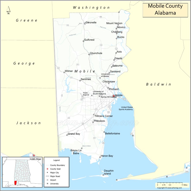
About Mobile County Map, Alabama: The map showing the county boundary, county seat, major cities, highways, water bodies and neighbouring counties.
Most Viewed Links
Map of Mobile County, Alabama
Mobile County is a county located in the U.S. state of Alabama. It`s county seat is Mobile. As per 2020 census, the population of Mobile County was 413073 and population density of Mobile was 336square miles. According to the United States Census Bureau, the county has a total area of 1,229.44 sq mi (3,184 km2). Mobile County was established on 1812.
Mobile County Facts
| Continent | North America |
| Country | United States |
| State | Alabama |
| County Seat | Mobile |
| Largest City/Town | Mobile |
| Established | December 18, 1812 |
| Total Area | 1,644 sq mi (4,258 sq km) |
| Land Area | 1,229 sq mi (3,183 sq km) |
| Water Area | 415 sq mi (1,075 sq km) |
| Population | 414,809 (Census 2020) |
| Population Density | 338 people per sq mi |
| Time Zone | Central Time Zone (CT) |
| Major Highways | Interstate 10, Interstate 65, Interstate 165, US 43, US 45, US 90, US 98, AL 158, AL 193 |
| Major Rivers | Mobile River, Tensaw River, Alabama River, Tombigbee River, Dog River |
| Neighboring Counties | Baldwin County, Washington County, Clarke County, George County (MS), Greene County (MS) |
| Famous For | Port of Mobile, Mardi Gras, Gulf Coast heritage, aerospace industry, and historic architecture |
| Top Attractions | USS Alabama Battleship Memorial Park, Mobile Carnival Museum, GulfQuest, Bellingrath Gardens, and Dauphin Island |
| Official Website | Official Website |
About Mobile County, Alabama
Mobile County is located in southwestern Alabama along the Gulf Coast and was established in 1812. The county seat and largest city is Mobile. The county is home to Alabama's only saltwater port and has a rich history influenced by French, Spanish, British, and American cultures. Mobile County features coastal landscapes, rivers, bays, historic districts, major industries, and one of the oldest Mardi Gras celebrations in the United States.
Cities and Towns in Mobile County, Alabama
| City/Town | Population (Census 2020) | Latitude & Longitude |
|---|---|---|
| Mobile (county seat) | 187,041 | 30.6954°N, 88.0399°W |
| Prichard | 19,322 | 30.7388°N, 88.0789°W |
| Saraland | 14,385 | 30.8207°N, 88.0706°W |
| Chickasaw | 6,757 | 30.7638°N, 88.0747°W |
| Satsuma | 6,427 | 30.8532°N, 88.0569°W |
| Semmes | 6,000 | 30.7788°N, 88.2597°W |
| Creola | 1,936 | 30.8910°N, 88.0392°W |
| Bayou La Batre | 2,204 | 30.4030°N, 88.2481°W |
| Citronelle | 3,905 | 31.0907°N, 88.2281°W |
| Dauphin Island | 1,778 | 30.2557°N, 88.1097°W |
| Mount Vernon | 1,354 | 31.0854°N, 88.0136°W |
| Axis (CDP) | 1,610 | 30.9291°N, 88.0172°W |
| Theodore (CDP) | 6,130 | 30.5477°N, 88.1750°W |
| Tillmans Corner (CDP) | 17,731 | 30.5902°N, 88.1708°W |
| Irvington (CDP) | 1,213 | 30.4827°N, 88.2286°W |
| Grand Bay (CDP) | 3,672 | 30.4769°N, 88.3420°W |
| Wilmer (CDP) | 3,682 | 30.8238°N, 88.3592°W |
| Movico (CDP) | 305 | 30.9235°N, 88.0154°W |
Best Golf Courses in Mobile County, Alabama
| Golf Course | Location | Latitude & Longitude |
|---|---|---|
| Magnolia Grove - Crossings Course | Mobile | 30.7346°N, 88.2012°W |
| Magnolia Grove - Falls Course | Mobile | 30.7346°N, 88.2012°W |
| Magnolia Grove - Short Course | Mobile | 30.7346°N, 88.2012°W |
| Country Club of Mobile | Mobile | 30.6680°N, 88.1145°W |
| Heron Lakes Country Club | Mobile | 30.7448°N, 88.1407°W |
| Azalea City Golf Course | Mobile | 30.7009°N, 88.1094°W |
| Spring Hill Golf Course | Mobile | 30.6967°N, 88.1283°W |
| Isle Dauphine Golf Club | Dauphin Island | 30.2488°N, 88.1116°W |
| TimberCreek Golf Club South Extension | Saraland Area | 30.8264°N, 88.0730°W |
What are Major Roads and Highways in Mobile County
Major highways connect the county to nearby regions and cities.
- Interstate 10 - east-west interstate connecting Mobile with New Orleans and Pensacola
- Interstate 65 - major north-south interstate connecting Mobile with Montgomery and Birmingham
- Interstate 165 - spur route linking downtown Mobile to Interstate 65
- US Highway 90 - historic Gulf Coast route through Mobile and Theodore
- US Highway 98 - connects Mobile with Mississippi and Baldwin County
- US Highway 43 - route connecting Mobile with northern Alabama
- US Highway 45 - connects Mobile with Mississippi communities
- Alabama State Route 193 - access route to Dauphin Island
- Alabama State Route 158 - major connector in northern Mobile County
Neighboring Counties of Mobile County
- Washington County (north)
- Clarke County (northeast)
- Baldwin County (east)
- George County, Mississippi (west)
- Greene County, Mississippi (northwest)
What are Top Attractions in Mobile County, Alabama
The county offers a mix of natural and cultural attractions.
| Main Sight Name | City | Famous For |
|---|---|---|
| USS Alabama Battleship Memorial Park | Mobile | Historic battleship and military aircraft exhibits |
| Mobile Carnival Museum | Mobile | History of Mardi Gras celebrations |
| GulfQuest National Maritime Museum | Mobile | Interactive maritime history exhibits |
| Bellingrath Gardens and Home | Theodore | Beautiful gardens and historic estate |
| Dauphin Island | Dauphin Island | Beaches, birding, and coastal recreation |
| Fort Gaines | Dauphin Island | Civil War-era coastal fortification |
| Mobile Bay | Mobile | Boating, fishing, and waterfront scenery |
| Historic Oakleigh House Museum | Mobile | Antebellum architecture and history |
| Bienville Square | Mobile | Historic downtown park and events |
| Mobile Museum of Art | Mobile | Regional and international art collections |
| Five Rivers Delta Resource Center | Spanish Fort Area | Access to the Mobile-Tensaw Delta ecosystem |
| Blakely State Park | Mobile Bay Area | Civil War history and nature trails |
| Cathedral Basilica of the Immaculate Conception | Mobile | Historic religious landmark |
| Africatown Heritage House | Mobile | History of the Clotilda and Africatown community |
Distance from Mobile County to Nearby Cities
The following distances are measured by road (driving).
- Mobile to Prichard (Mobile County), Alabama - 7 mi (11 km)
- Mobile to Saraland (Mobile County), Alabama - 12 mi (19 km)
- Mobile to Semmes (Mobile County), Alabama - 14 mi (23 km)
- Mobile to Theodore (Mobile County), Alabama - 14 mi (23 km)
- Mobile to Bayou La Batre (Mobile County), Alabama - 32 mi (51 km)
- Mobile to Dauphin Island (Mobile County), Alabama - 42 mi (68 km)
- Mobile to Fairhope (Baldwin County), Alabama - 23 mi (37 km)
- Mobile to Foley (Baldwin County), Alabama - 39 mi (63 km)
- Mobile to Atmore (Escambia County), Alabama - 57 mi (92 km)
- Mobile to Jackson (Clarke County), Alabama - 58 mi (93 km)
- Mobile to Pascagoula, Mississippi - 42 mi (68 km)
- Mobile to Biloxi, Mississippi - 61 mi (98 km)
- Mobile to Pensacola, Florida - 58 mi (93 km)
- Mobile to Montgomery (Montgomery County), Alabama - 170 mi (274 km)
- Mobile to New Orleans, Louisiana - 144 mi (232 km)
Nearest Airports
Nearest airport of Mobile is Mobile Regional Airport.
References
- QuickFacts - U.S. Census Bureau
- United States Census Bureau
- United States Geological Survey (USGS)
- National Geodetic Survey
- Official County Website
- Autauga County Map
- Baldwin County Map
- Barbour County Map
- Bibb County Map
- Blount County Map
- Bullock County Map
- Butler County Map
- Calhoun County Map
- Chambers County Map
- Cherokee County Map
- Chilton County Map
- Choctaw County Map
- Clarke County Map
- Clay County Map
- Cleburne County Map
- Coffee County Map
- Colbert County Map
- Conecuh County Map
- Coosa County Map
- Covington County Map
- Crenshaw County Map
- Cullman County Map
- Dale County Map
- Dallas County Map
- DeKalb County Map
- Elmore County Map
- Escambia County Map
- Etowah County Map
- Fayette County Map
- Franklin County Map
- Geneva County Map
- Greene County Map
- Hale County Map
- Henry County Map
- Houston County Map
- Jackson County Map
- Jefferson County Map
- Lamar County Map
- Lauderdale County Map
- Lawrence County Map
- Lee County Map
- Limestone County Map
- Lowndes County Map
- Macon County Map
- Madison County Map
- Marengo County Map
- Marion County Map
- Marshall County Map
- Mobile County Map
- Monroe County Map
- Montgomery County Map
- Morgan County Map
- Perry County Map
- Pickens County Map
- Pike County Map
- Randolph County Map
- Russell County Map
- St Clair County Map
- Shelby County Map
- Sumter County Map
- Talladega County Map
- Tallapoosa County Map
- Tuscaloosa County Map
- Walker County Map
- Washington County Map
- Wilcox County Map
- Winston County Map
- Alabama Counties
- Alaska boroughs
- Arizona Counties
- Arkansas Counties
- California County Map
- Colorado Counties
- Connecticut Counties
- Delaware Counties
- Florida County Map
- Georgia County Map
- Hawaii Counties
- Idaho Counties
- Illinois Counties
- Indiana Counties
- Iowa Counties
- Kansas Counties
- Kentucky Counties
- Louisiana Counties
- Maine Counties
- Maryland Counties
- Massachusetts Counties
- Michigan County Map
- Minnesota Counties
- Mississippi Counties
- Missouri Counties
- Montana Counties
- Nebraska Counties
- Nevada Counties
- New York Counties
- New Hampshire Counties
- New Jersey Counties
- New Mexico Counties
- North Carolina Counties
- North Dakota Counties
- Ohio County Map
- Oklahoma Counties
- Oregon Counties
- Pennsylvania Counties
- Rhode Island Counties
- South Carolina Counties
- South Dakota Counties
- Map of Tennessee
- Texas County Map
- Utah Counties
- Vermont Counties
- Virginia Counties
- Washington Counties
- West Virginia Counties
- Wisconsin Counties
- Wyoming Counties