Map of Tuscaloosa County - Tuscaloosa County is a county located in the U.S. state of Alabama. Tuscaloosa County Map showing cities, highways, important places and water bodies. Get Where is Tuscaloosa County located in the map, major cities in Tuscaloosa county, population, areas, and places of interest.
Tuscaloosa County Map, Alabama
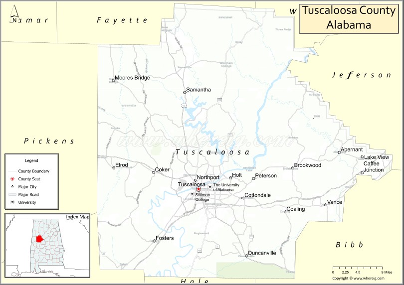
About Tuscaloosa County Map, Alabama: The map showing the county boundary, county seat, major cities, highways, water bodies and neighbouring counties.
Most Viewed Links
Map of Tuscaloosa County, Alabama
Tuscaloosa County is a county located in the U.S. state of Alabama. It`s county seat is Tuscaloosa. As per 2020 census, the population of Tuscaloosa County was 227007 and population density of Tuscaloosa was 171.7square miles. According to the United States Census Bureau, the county has a total area of 1,321.75 sq mi (3,423 km2). Tuscaloosa County was established on 1818.
Tuscaloosa County Facts
| County Info | Facts |
|---|---|
| County | Tuscaloosa County |
| County Seat | Tuscaloosa |
| State | Alabama |
| Country | United States |
| FIPS code | 125 |
| Established | 1818 |
| Area | 1,321.75 sq mi (3,423 km2) |
| Population | 227007 |
| Density | 171.7 |
| Formed / Origin | Montgomery County and Choctaw territory |
Ctities and Towns in Tuscaloosa
| City Name | Type | Population (2020) | Pop. Density | Area |
|---|---|---|---|---|
| Woodstock | Town | 1,472 | 207.9/sq mi (80.3/km2) | 7.08 sq mi (18.3 km2) |
| Moundville | Town | 3,024 | 658.8/sq mi (254.4/km2) | 4.59 sq mi (11.9 km2) |
| Brookwood | Town | 2,504 | 299.5/sq mi (115.6/km2) | 8.36 sq mi (21.7 km2) |
| Coaling | Town | 2,035 | 405.4/sq mi (156.5/km2) | 5.02 sq mi (13 km2) |
| Coker | Town | 904 | 445.3/sq mi (171.9/km2) | 2.03 sq mi (5.3 km2) |
| Lake View | Town | 3,560 | 2,225.0/sq mi (859.1/km2) | 1.6 sq mi (4.1 km2) |
| Northport | City | 31,125 | 1,858.2/sq mi (717.5/km2) | 16.75 sq mi (43.4 km2) |
| Tuscaloosa | City | 99,600 | 1,653.7/sq mi (638.5/km2) | 60.23 sq mi (156 km2) |
| Vance | Town | 2,092 | 205.5/sq mi (79.3/km2) | 10.18 sq mi (26.4 km2) |
Places to Visit in Tuscaloosa
Top places to visit in london includes Bryant-Denny Stadium,Alabama Museum,Capitol Park,Jemison-Van De Graaff Mansion,Will May Dog Park, Monnish Park, Lake Nicol, Goldie 1971 - The Fallen Robot,Snow Hinton Park, Hurricane Creek Park, Tuscaloosa Riverwalk, Moundville Archaeological, Oak Mountain State Park, Robert Cardinal Park, Lake Lurleen, Holt Lock and Dam, Deerlick Creek Public Use Area, Rocky Branch Public Use Area, Hurricane Creek.
Highways in Tuscaloosa
highways US 11, highways US 43, highwaysUS 82.
Nearest Airports
Nearest airport of Tuscaloosa is Tuscaloosa Regional Airport.
- Autauga County Map
- Baldwin County Map
- Barbour County Map
- Bibb County Map
- Blount County Map
- Bullock County Map
- Butler County Map
- Calhoun County Map
- Chambers County Map
- Cherokee County Map
- Chilton County Map
- Choctaw County Map
- Clarke County Map
- Clay County Map
- Cleburne County Map
- Coffee County Map
- Colbert County Map
- Conecuh County Map
- Coosa County Map
- Covington County Map
- Crenshaw County Map
- Cullman County Map
- Dale County Map
- Dallas County Map
- DeKalb County Map
- Elmore County Map
- Escambia County Map
- Etowah County Map
- Fayette County Map
- Franklin County Map
- Geneva County Map
- Greene County Map
- Hale County Map
- Henry County Map
- Houston County Map
- Jackson County Map
- Jefferson County Map
- Lamar County Map
- Lauderdale County Map
- Lawrence County Map
- Lee County Map
- Limestone County Map
- Lowndes County Map
- Macon County Map
- Madison County Map
- Marengo County Map
- Marion County Map
- Marshall County Map
- Mobile County Map
- Monroe County Map
- Montgomery County Map
- Morgan County Map
- Perry County Map
- Pickens County Map
- Pike County Map
- Randolph County Map
- Russell County Map
- St Clair County Map
- Shelby County Map
- Sumter County Map
- Talladega County Map
- Tallapoosa County Map
- Tuscaloosa County Map
- Walker County Map
- Washington County Map
- Wilcox County Map
- Winston County Map
- Alabama Counties
- Alaska boroughs
- Arizona Counties
- Arkansas Counties
- California County Map
- Colorado Counties
- Connecticut Counties
- Delaware Counties
- Florida County Map
- Georgia County Map
- Hawaii Counties
- Idaho Counties
- Illinois Counties
- Indiana Counties
- Iowa Counties
- Kansas Counties
- Kentucky Counties
- Louisiana Counties
- Maine Counties
- Maryland Counties
- Massachusetts Counties
- Michigan County Map
- Minnesota Counties
- Mississippi Counties
- Missouri Counties
- Montana Counties
- Nebraska Counties
- New Hampshire Counties
- New Jersey Counties
- New Mexico Counties
- North Carolina Counties
- North Dakota Counties
- Oklahoma Counties
- Oregon Counties
- Pennsylvania Counties
- Rhode Island Counties
- South Carolina Counties
- South Dakota Counties
- Map of Tennessee
- Texas County Map
- Utah Counties
- Vermont Counties
- Virginia Counties
- Washington Counties
- West Virginia Counties
- Wisconsin Counties
- Wyoming Counties
- Nevada Counties
- New York Counties
- Ohio County Map