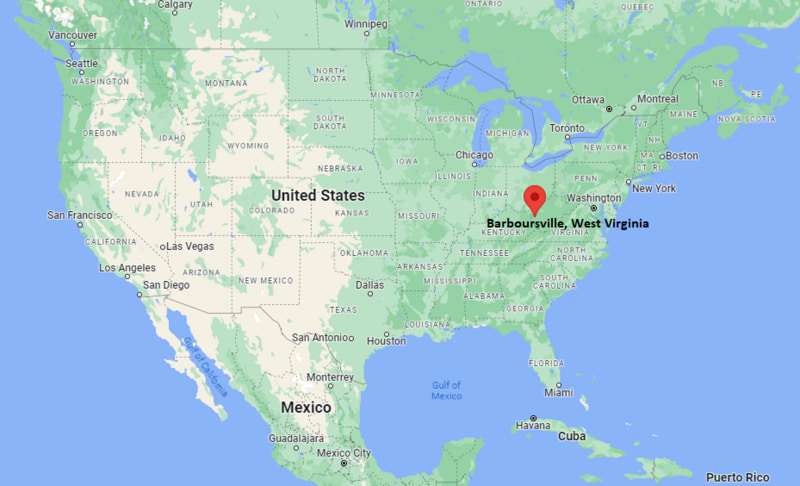
Where is Barboursville Located? - Barboursville is a city located in the Cabell County of West Virginia, United States. Barboursville lies between 38.4095 Degrees North latitudes and 82.2946 Degrees West longitudes.
Location Map of Barboursville, West Virginia
Barboursville Map, West Virginia, USA
Where is Barboursville?: The Google Map showing the location of Barboursville in the U.S. state of West Virginia.
Where is Barboursville Located?
Barboursville is a village located in the Cabell County of West Virginia, United States. Barboursville lies at approximately 38.4095 Degrees North latitude and 82.2946 Degrees West longitude. According to the 2020 U.S. Census, the population of Barboursville village is 4,456 people and the village has a total area of 4.09 sq mi. The village has numerous parks and recreational facilities.
Nearby Cities and Communities to Barboursville, West Virginia
Huntington, West Virginia - 8 mi (13 km)
Milton, West Virginia - 7 mi (11 km)
Culloden, West Virginia - 8 mi (13 km)
Pea Ridge, West Virginia - 5 mi (8 km)
Lesage, West Virginia - 9 mi (14 km)
Hurricane, West Virginia - 18 mi (29 km)
Ashland, Kentucky - 18 mi (29 km)
Chesapeake, Ohio - 15 mi (24 km)
Charleston, West Virginia - 50 mi (80 km)
Portsmouth, Ohio - 60 mi (97 km)
Barboursville, West Virginia Climate and Weather Overview
Month
Avg High
Avg Low
Avg Precipitation
January
43°F
25°F
3.3 in
April
67°F
44°F
4.2 in
July
87°F
66°F
4.5 in
October
69°F
46°F
2.8 in
Climate Attribute
Details
Climate Type
Humid Subtropical (Cfa)
Annual Rainfall
Approximately 45 inches
Annual Sunshine
Approximately 180 sunny days
Average Snowfall
15 inches annually
Main Weather Risks
Thunderstorms, Flooding and Winter Storms
Driving Distances from Barboursville, West Virginia
Destination
Distance
Distance (km)
Drive Time
Huntington
8 mi
13 km
15 min
Milton
7 mi
11 km
10 min
Culloden
8 mi
13 km
10 min
Pea Ridge
5 mi
8 km
8 min
Hurricane
18 mi
29 km
20 min
Ashland
18 mi
29 km
25 min
Chesapeake
15 mi
24 km
20 min
Charleston
50 mi
80 km
50 min
Portsmouth
60 mi
97 km
1 hr 10 min
Transportation and Connectivity in Barboursville, West Virginia
Nearest Airport
Tri-State Airport
IATA Code
HTS
Major Airport
Tri-State Airport (HTS)
Major Highways
Interstate 64, U.S. Route 60, West Virginia Route 2
Rail Service
Freight Rail Service Nearby
Public Transit
Tri-State Transit Authority (TTA)
Barboursville is a historic village located in Cabell County near Huntington.
The village is known for its shopping, parks and convenient location along Interstate 64.
Retail, healthcare, education and service industries are major economic contributors.
Barboursville Mall serves as one of the region's primary shopping destinations.
The community offers a blend of small-town character and metropolitan accessibility.
Key Landmarks and Places to Visit in Barboursville, West Virginia
Landmark
Type
Barboursville Park
Community Park
Barboursville Historic District
Historic Area
Miller House Museum
Historic Museum
Barboursville Mall
Shopping Center
Village Park Amphitheater
Entertainment Venue
Beech Fork State Park
State Park
Heritage Farm Museum and Village
Living History Museum
Huntington Museum of Art
Art Museum
Colleges and Universities Near Barboursville, West Virginia
Institution
Type
Distance
Notable For
Marshall University
Public University
10 mi
Research, healthcare and engineering
Mountwest Community and Technical College
Community College
12 mi
Career and technical education
Ohio University Southern
Regional Campus
18 mi
Business and education programs
Ashland Community and Technical College
Community College
20 mi
Workforce development
University of Charleston
Private University
50 mi
Business and healthcare programs
Waterbodies in and Near Barboursville, West Virginia
Mud River, Ohio River, Guyandotte River, Beech Fork Lake, Twelvepole Creek, East Fork Twelvepole Creek, Raccoon Creek, Hurricane Creek, Kanawha River and Grassy Creek.
Golf Courses in and Near Barboursville, West Virginia
Esquire Golf Course, Guyan Golf and Country Club, Sugarwood Golf Club, Creekside Golf Course, Hidden Valley Country Club, Sandy Creek Golf Course, Willow Ridge Golf Club and River Bend Golf Club.
Barboursville, West Virginia - Key Historical Facts
Barboursville was founded in 1813 and named after Virginia governor James Barbour.
The village became an important transportation and trading center during the nineteenth century.
Barboursville suffered significant damage during the Civil War, including the burning of the county courthouse.
The arrival of railroads and improved highways helped stimulate economic growth.
The community developed into a regional commercial center during the twentieth century.
Today, Barboursville is known for its historic heritage, retail centers and recreational amenities.