
Where is Shady Spring Located? - Shady Spring is a city located in the Raleigh County of West Virginia, United States. Shady Spring lies between 40.3768954 Degrees North latitudes and 111.7957645 Degrees West longitudes.
Location Map of Shady Spring, West Virginia
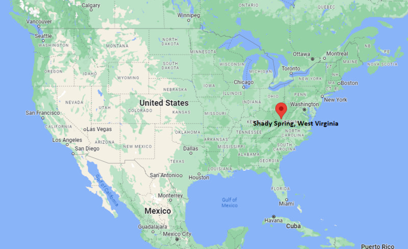
Shady Spring Map, West Virginia, USA
Where is Shady Spring?: The Google Map showing the location of Shady Spring in the U.S. state of West Virginia.
Where is Shady Spring Located?
Shady Spring is a city located in the Raleigh County of West Virginia, United States. Shady Spring lies between 40.3768954 Degrees North latitudes and 111.7957645 Degrees West longitudes. According to 2020 U.S.census, the population of Shady Spring city is 3169 people and the city has a total area of 6.07 sq mi. The city has numerous parks and recreational facilities.
Most Viewed US Maps
| USA Sttae Map | USA Region Map | USA Road Map |
| USA County Map | Where is USA in World Map? | US ZIP Code Map |
| USA Time Zones Map | US State and Capitals Map | USA Physical Map |
Find 4,400+ U.S. Cities by State - Explore Their Locations and Get Detailed Information
Shady Spring, West Virginia Quick Facts
| Attribute | Details |
|---|---|
| City | Shady Spring |
| County | Raleigh County |
| State | West Virginia |
| State Capital | Charleston |
| US Region | Southern United States |
| Latitude | 37.7458° N |
| Longitude | 81.0099° W |
| Elevation | 2,763 ft (842 m) |
| Land Area (sq mi) | 6.10 |
| Water Area (sq mi) | 0.10 |
| Total Area (sq mi) | 6.20 |
| Population (2020 Census) | 3,169 |
| Population Density (per sq mi) | 519.5 |
| ZIP Codes | 25918 |
| Area Code | 304, 681 |
| Time Zone Standard | Eastern Standard Time (EST), UTC−5 |
| Time Zone Daylight | Eastern Daylight Time (EDT), UTC−4 |
| Currency | United States Dollar (USD) |
| FIPS Code | 5473108 |
| Congressional District | 1st Congressional District |
Transportation and Connectivity in Shady Spring
| Transportation Feature | Details |
|---|---|
| Airport Name | Raleigh County Memorial Airport; Yeager Airport provides major commercial air service. |
| IATA Code | BKW; CRW for Yeager Airport |
| Port | None |
| Major Highways | U.S. Route 19, Interstate 64, Interstate 77, and West Virginia Route 3 |
| Train/Amtrak Service | No Amtrak passenger station is located in Shady Spring. Nearby rail service is available in Prince and other regional locations. |
| Local Bus/Transit Service | Raleigh County public transportation services provide regional connections. |
- U.S. Route 19 runs north-south through the region and connects Shady Spring with Beckley, Fayetteville, and communities in southern West Virginia.
- Interstate 64 provides east-west access between Shady Spring, Beckley, Charleston, and Virginia destinations.
- Interstate 77 connects the area with southern West Virginia, Ohio, and Virginia transportation corridors.
- West Virginia Route 3 provides local connections through Raleigh County and surrounding communities.
Top Places to Visit in Shady Spring, West Virginia
| Landmark Name | Type |
|---|---|
| New River Gorge National Park and Preserve | National Park |
| Winterplace Ski Resort | Ski Resort |
| Little Beaver State Park | State Park |
| Glade Springs Resort | Resort and Recreation Area |
| Flat Top Lake | Lake |
| Raleigh County Veterans Museum | Museum |
| Beckley Exhibition Coal Mine | Historic Attraction |
| Tamarack Marketplace | Cultural Center |
| Grandview | Scenic Area |
| Sandstone Falls | Natural Attraction |
Driving Distances from Shady Spring, West Virginia to Nearby Cities
| City | State | Distance (mi) | Approx. Drive Time |
|---|---|---|---|
| Beckley | West Virginia | 10 | 15 min |
| Oak Hill | West Virginia | 30 | 40 min |
| Fayetteville | West Virginia | 35 | 45 min |
| Princeton | West Virginia | 40 | 45 min |
| Bluefield | West Virginia | 55 | 1 hr |
| Charleston | West Virginia | 65 | 1 hr 15 min |
| Lewisburg | West Virginia | 65 | 1 hr 15 min |
| Roanoke | Virginia | 120 | 2 hr |
| Charlottesville | Virginia | 180 | 3 hr |
| Richmond | Virginia | 230 | 3 hr 45 min |
Colleges and Universities in Shady Spring, West Virginia
| Institution Name | Type | Level | Notable For |
|---|---|---|---|
| New River Community and Technical College | Public | Community College | Career and technical education |
| West Virginia University Institute of Technology | Public | University | Engineering and applied sciences |
| Bluefield State University | Public | University | Historically Black university and STEM programs |
| West Virginia University | Public | University | Research and higher education |
Waterbodies in Shady Spring, West Virginia
Little Beaver Creek, Flat Top Lake, New River, Bluestone River, Glade Creek
Golf Courses in Shady Spring, West Virginia
Glade Springs Village Golf Course, Grandview Golf Course, Briarwood Golf Course
Key Landmarks and Places to Visit in Shady Spring, West Virginia
| Landmark Name | Type |
|---|---|
| New River Gorge National Park and Preserve | National Park |
| Winterplace Ski Resort | Ski Resort |
| Little Beaver State Park | State Park |
| Glade Springs Resort | Resort and Recreation Area |
| Flat Top Lake | Lake |
| Raleigh County Veterans Museum | Museum |
| Beckley Exhibition Coal Mine | Historic Attraction |
| Tamarack Marketplace | Cultural Center |
| Grandview | Scenic Area |
| Sandstone Falls | Natural Attraction |
Waterbodies in Shady Spring, West Virginia
Little Beaver Creek, Flat Top Lake, New River, Bluestone River, Glade Creek
Golf Courses in Shady Spring, West Virginia
Glade Springs Village Golf Course, Grandview Golf Course, Briarwood Golf Course
Shady Spring, West Virginia — Key Historical Facts
- Shady Spring developed as a rural community in Raleigh County with roots connected to farming and mountain settlements.
- The community grew near important transportation routes that connected southern West Virginia communities.
- The nearby coal industry played an important role in the economic development of Raleigh County during the 20th century.
- Shady Spring's location near Beckley helped it become a residential community within the southern West Virginia region.
- The area's natural landscapes and access to outdoor recreation have made Shady Spring part of the growing tourism region around the New River Gorge.
References
- Raleigh County Government
- U.S. Census Bureau
- New River Gorge National Park and Preserve — National Park Service
- West Virginia State Parks
- West Virginia Encyclopedia
- New River Community and Technical College
West Virginia Maps and Info
| West Virginia Map | Counties in West Virginia | Cities in West Virginia |
| West Virginia Zipcodes | Airports in West Virginia | US Zip code Map |
| West Virginia Area Codes | West Virginia River Map | - |
- Where is Barboursville
- Where is Beckley
- Where is Blennerhassett
- Where is Bluefield
- Where is Bridgeport
- Where is Brookhaven
- Where is Buckhannon
- Where is Charles Town
- Where is Charleston
- Where is Cheat Lake
- Where is Clarksburg
- Where is Cross Lanes
- Where is Culloden
- Where is Dunbar
- Where is Elkins
- Where is Fairmont
- Where is Grafton
- Where is Huntington
- Where is Hurricane
- Where is Inwood
- Where is Keyser
- Where is Lewisburg
- Where is Martinsburg
- Where is Morgantown
- Where is Moundsville
- Where is New Martinsville
- Where is Nitro
- Where is Oak Hill
- Where is Parkersburg
- Where is Pea Ridge
- Where is Pleasant Valley
- Where is Point Pleasant
- Where is Princeton
- Where is Ranson corporation
- Where is Ravenswood
- Where is Ripley
- Where is Shady Spring
- Where is Shannondale
- Where is Sissonville
- Where is South Charleston
- Where is St. Albans
- Where is Teays Valley
- Where is Vienna
- Where is Weirton
- Where is Welch
- Where is Weston
- Where is Westover
- Where is Wheeling
- Where is Williamson
- Where is Williamstown