
Where is Grafton Located? - Grafton is a city located in the Taylor County of West Virginia, United States. Grafton lies between 40.3141169 Degrees North latitudes and 112.006882 Degrees West longitudes.
Location Map of Grafton, West Virginia
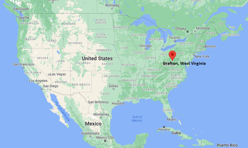
Grafton Map, West Virginia, USA
Where is Grafton?: The Google Map showing the location of Grafton in the U.S. state of West Virginia.
Where is Grafton Located?
Grafton is a city located in the Taylor County of West Virginia, United States. Grafton lies between 40.3141169 Degrees North latitudes and 112.006882 Degrees West longitudes. According to 2020 U.S.census, the population of Grafton city is 4722 people and the city has a total area of 3.67 sq mi. The city has numerous parks and recreational facilities.
Most Viewed US Maps
| USA Sttae Map | USA Region Map | USA Road Map |
| USA County Map | Where is USA in World Map? | US ZIP Code Map |
| USA Time Zones Map | US State and Capitals Map | USA Physical Map |
Find 4,400+ U.S. Cities by State - Explore Their Locations and Get Detailed Information
Grafton, West Virginia Quick Facts
| Property | Information |
|---|---|
| City | Grafton |
| County | Taylor County |
| State | West Virginia |
| State Capital | Charleston |
| US Region | Southern United States |
| Latitude | 39.3409°N |
| Longitude | 80.0189°W |
| Elevation | 1,001 ft (305 m) |
| Land Area | 3.74 sq mi |
| Water Area | 0.06 sq mi |
| Total Area | 3.80 sq mi |
| Population (latest Census year) | 4,729 (Census 2020) |
| Population Density (per sq mi) | Approximately 1,265 |
| ZIP Code | 26354 |
| Area Code | 304 |
| Time Zone Standard | Eastern Standard Time (EST, UTC−5) |
| Time Zone Daylight | Eastern Daylight Time (EDT, UTC−4) |
| Currency | United States Dollar (USD) |
| FIPS Code | 54-32812 |
| Congressional District | West Virginia's 1st Congressional District |
Nearby Cities to Grafton, West Virginia
- Fairmont, West Virginia — 18 mi Southwest
- Philippi, West Virginia — 18 mi South
- Bridgeport, West Virginia — 28 mi Southwest
- Clarksburg, West Virginia — 32 mi Southwest
- Morgantown, West Virginia — 35 mi Northwest
- Elkins, West Virginia — 45 mi Southeast
- Weston, West Virginia — 45 mi Southwest
- Kingwood, West Virginia — 35 mi Northeast
- Buckhannon, West Virginia — 50 mi South
- Charleston, West Virginia — 125 mi Southwest
Driving Distances from Grafton, West Virginia
| City | State | Distance (mi) | Approx. Drive Time |
|---|---|---|---|
| Fairmont | West Virginia | 18 | 25 minutes |
| Philippi | West Virginia | 18 | 30 minutes |
| Bridgeport | West Virginia | 28 | 40 minutes |
| Clarksburg | West Virginia | 32 | 45 minutes |
| Morgantown | West Virginia | 35 | 45 minutes |
| Kingwood | West Virginia | 35 | 50 minutes |
| Elkins | West Virginia | 45 | 1 hour |
| Weston | West Virginia | 45 | 1 hour |
| Buckhannon | West Virginia | 50 | 1 hour 10 minutes |
| Charleston | West Virginia | 125 | 2 hours 30 minutes |
Transportation and Connectivity in Grafton, West Virginia
| Transportation | Details |
|---|---|
| Airport Name | North Central West Virginia Airport |
| IATA Code | CKB |
| Port | Not Applicable |
| Major Highways | U.S. Route 50, U.S. Route 119, West Virginia Route 92 |
| Train/Amtrak Service | Amtrak service available through nearby stations |
| Local Bus/Transit Service | Mountain Line Transit Authority regional connections |
- U.S. Route 50 - Major east-west highway connecting Grafton with northern West Virginia communities.
- U.S. Route 119 - Regional highway connecting Grafton with Fairmont and surrounding areas.
- West Virginia Route 92 - Scenic route connecting Grafton with mountain communities.
What are top Places to Visit in Grafton, West Virginia
| Landmark Name | Type |
|---|---|
| Mother's Day Shrine | Historic Landmark |
| Taylor County Historical and Genealogical Society Museum | Museum |
| Grafton National Cemetery | Historic Cemetery |
| Valley Falls State Park | State Park |
| Prickett's Fort State Park | Historic Park |
| Tygart Lake State Park | State Park |
| Tygart Valley River | Natural Attraction |
| West Virginia Botanic Garden | Garden |
| Harrison County Historical Society Museum | Museum |
| Audra State Park | State Park |
Colleges and Universities in Grafton, West Virginia
| Institution Name | Type | Level | Notable For |
|---|---|---|---|
| Fairmont State University | Public | University | Applied sciences, business, education, and professional programs |
| West Virginia University | Public | University | Research, engineering, medicine, and academic programs |
| BridgeValley Community and Technical College | Public | Community College | Technical education and workforce training |
| Pierpont Community & Technical College | Public | Community College | Career programs, technology, and applied sciences |
| Taylor County Schools | Public | K–12 District | Public education services |
Waterbodies in Grafton, West Virginia
Tygart Valley River, Valley River, Three Fork Creek, Tygart Lake, Cheat River
Golf Courses in Grafton, West Virginia
Grafton Country Club, Bel Meadow Golf Club, Preston Country Club, Bridgeport Country Club, Valley Falls Golf Course
Grafton, West Virginia — Key Historical Facts
- Grafton was founded in the mid-nineteenth century and was incorporated as a town in 1856.
- The city became an important railroad center due to its location along the Baltimore and Ohio Railroad network.
- Grafton is the birthplace of the Mother's Day holiday celebration, with the first official observance held there in 1908 at Andrews Methodist Episcopal Church.
- Grafton played an important role during the American Civil War because of its strategic railroad location.
- The city became the final resting place for many Civil War veterans at the Grafton National Cemetery, established in 1867.
- Today, Grafton is known for its railroad heritage, historic landmarks, outdoor recreation, and connection to Mother's Day history.
References
West Virginia Maps and Info
| West Virginia Map | Counties in West Virginia | Cities in West Virginia |
| West Virginia Zipcodes | Airports in West Virginia | US Zip code Map |
| West Virginia Area Codes | West Virginia River Map | - |
- Where is Barboursville
- Where is Beckley
- Where is Blennerhassett
- Where is Bluefield
- Where is Bridgeport
- Where is Brookhaven
- Where is Buckhannon
- Where is Charles Town
- Where is Charleston
- Where is Cheat Lake
- Where is Clarksburg
- Where is Cross Lanes
- Where is Culloden
- Where is Dunbar
- Where is Elkins
- Where is Fairmont
- Where is Grafton
- Where is Huntington
- Where is Hurricane
- Where is Inwood
- Where is Keyser
- Where is Lewisburg
- Where is Martinsburg
- Where is Morgantown
- Where is Moundsville
- Where is New Martinsville
- Where is Nitro
- Where is Oak Hill
- Where is Parkersburg
- Where is Pea Ridge
- Where is Pleasant Valley
- Where is Point Pleasant
- Where is Princeton
- Where is Ranson corporation
- Where is Ravenswood
- Where is Ripley
- Where is Shady Spring
- Where is Shannondale
- Where is Sissonville
- Where is South Charleston
- Where is St. Albans
- Where is Teays Valley
- Where is Vienna
- Where is Weirton
- Where is Welch
- Where is Weston
- Where is Westover
- Where is Wheeling
- Where is Williamson
- Where is Williamstown