
Where is Elkins Located? - Elkins is a city located in the Randolph County of West Virginia, United States. Elkins lies between 40.5649781 Degrees North latitudes and 111.8389726 Degrees West longitudes.
Location Map of Elkins, West Virginia
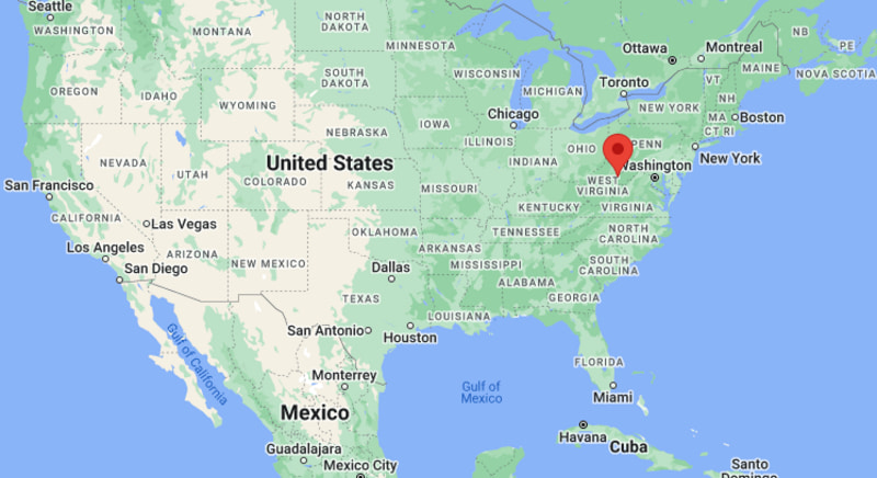
Elkins Map, West Virginia, USA
Where is Elkins?: The Google Map showing the location of Elkins in the U.S. state of West Virginia.
Where is Elkins Located?
Elkins is a city located in the Randolph County of West Virginia, United States. Elkins lies between 40.5649781 Degrees North latitudes and 111.8389726 Degrees West longitudes. According to 2020 U.S.census, the population of Elkins city is 6934 people and the city has a total area of 3.63 sq mi. The city has numerous parks and recreational facilities.
Most Viewed US Maps
| USA Sttae Map | USA Region Map | USA Road Map |
| USA County Map | Where is USA in World Map? | US ZIP Code Map |
| USA Time Zones Map | US State and Capitals Map | USA Physical Map |
Find 4,400+ U.S. Cities by State - Explore Their Locations and Get Detailed Information
Elkins, West Virginia Quick Facts
| Property | Details |
|---|---|
| City | Elkins |
| County | Randolph County |
| State | West Virginia |
| State Capital | Charleston |
| US Region | South |
| Latitude | 38.9254°N |
| Longitude | 79.8462°W |
| Elevation | 1,930 ft (588 m) |
| Land Area | 3.43 sq mi |
| Water Area | 0.03 sq mi |
| Total Area | 3.46 sq mi |
| Population (2020 Census) | 6,950 |
| Population Density | Approximately 2,026 per sq mi |
| ZIP Code | 26241 |
| Area Code | 304, 681 |
| Time Zone Standard | Eastern Standard Time (EST), UTC−5 |
| Time Zone Daylight | Eastern Daylight Time (EDT), UTC−4 |
| Currency | US Dollar (USD) |
| FIPS Code | 54-25516 |
| Congressional District | West Virginia's 2nd Congressional District |
Nearby Cities to Elkins, West Virginia
- Beverly, West Virginia - South - 8 mi
- Belington, West Virginia - Northwest - 12 mi
- Parsons, West Virginia - Northeast - 20 mi
- Buckhannon, West Virginia - West - 30 mi
- Philippi, West Virginia - Northwest - 28 mi
- Thomas, West Virginia - Northeast - 33 mi
- Davis, West Virginia - Northeast - 36 mi
- Marlinton, West Virginia - South - 47 mi
- Bridgeport, West Virginia - Northwest - 49 mi
- Clarksburg, West Virginia - Northwest - 56 mi
Elkins, West Virginia Climate and Weather Overview
| Month | Avg High (°F) | Avg Low (°F) | Avg Rainfall (in) |
|---|---|---|---|
| January | 37 | 20 | 3.10 |
| April | 60 | 37 | 4.10 |
| July | 81 | 59 | 4.80 |
| October | 63 | 40 | 3.10 |
| Annual | 60 | 39 | 48.50 |
| Climate Attribute | Details |
|---|---|
| Climate Classification (Köppen) | Humid Continental (Dfb) |
| Annual Rainfall | Approximately 49 inches |
| Annual Sunshine Days | About 165 days |
| Hurricane/Tornado Risk | Very low hurricane risk; low tornado risk |
| Snowfall | Approximately 45 inches annually |
Driving Distances from Elkins, West Virginia
| City | State | Distance (mi) | Approx. Drive Time |
|---|---|---|---|
| Beverly | West Virginia | 8 | 12 min |
| Belington | West Virginia | 12 | 18 min |
| Parsons | West Virginia | 20 | 28 min |
| Philippi | West Virginia | 28 | 35 min |
| Buckhannon | West Virginia | 30 | 40 min |
| Thomas | West Virginia | 33 | 45 min |
| Davis | West Virginia | 36 | 50 min |
| Marlinton | West Virginia | 47 | 1 hr |
| Bridgeport | West Virginia | 49 | 1 hr |
| Charleston | West Virginia | 156 | 2 hr 40 min |
Transportation and Connectivity in Elkins, West Virginia
| Transportation | Details |
|---|---|
| Airport Name | Elkins-Randolph County Regional Airport |
| IATA Code | EKN |
| Port | None |
| Major Highways | U.S. Highway 33, U.S. Highway 219, West Virginia Route 92, West Virginia Route 55 |
| Train/Amtrak Service | No Amtrak service; excursion rail service via Durbin & Greenbrier Valley Railroad |
| Local Bus/Transit Service | Mountain Transit Authority |
- U.S. Highway 33 is the principal east-west route connecting Elkins with Harrisonburg, Virginia, and Weston, West Virginia.
- U.S. Highway 219 provides north-south access to Parsons, Marlinton, and other Appalachian communities.
- West Virginia Routes 92 and 55 offer scenic drives through the Monongahela National Forest and nearby mountain regions.
- Elkins-Randolph County Regional Airport supports general aviation, while the historic Durbin & Greenbrier Valley Railroad operates popular heritage train excursions.
Places to Visit in Elkins, West Virginia
| Landmark Name | Type |
|---|---|
| Monongahela National Forest | National Forest |
| Elkins Depot Welcome Center | Visitor Center |
| Durbin & Greenbrier Valley Railroad | Scenic Heritage Railroad |
| Davis & Elkins College Graceland Mansion | Historic Mansion |
| Augusta Heritage Center | Cultural Center |
| West Virginia Railroad Museum | Railroad Museum |
| Elkins City Park | City Park |
| Bickle Knob Observation Tower | Scenic Overlook |
| Stuart Recreation Area | Outdoor Recreation Area |
| Seneca Rocks | Natural Landmark |
Colleges and Universities in Elkins, West Virginia
| Institution Name | Type | Level | Notable For |
|---|---|---|---|
| Davis & Elkins College | Private | College | Liberal arts, business, and performing arts |
| Eastern West Virginia Community and Technical College | Public | Community College | Career and workforce education |
| West Virginia Wesleyan College | Private | College | Liberal arts and professional programs |
| Fairmont State University | Public | University | Business, education, and healthcare |
| West Virginia University | Public | University | Research and graduate education |
| Potomac State College of WVU | Public | College | Associate and bachelor's degree programs |
| Pierpont Community and Technical College | Public | Community College | Technical and career education |
| Randolph County Schools | Public | K–12 District | Primary and secondary education |
Waterbodies in Elkins, West Virginia
Tygart Valley River, Shavers Fork, Dry Fork, Cheat River, Stonecoal Lake, Spruce Knob Lake, Glady Fork, Seneca Creek
Golf Courses in Elkins, West Virginia
Elks Golf Course, Canaan Valley Resort Golf Course, Preston Country Club, Bridgeport Country Club, Bel Meadow Golf Club, Stonewall Resort Golf Course, Riverside Golf Club, Clarksburg Country Club
Elkins, West Virginia — Key Historical Facts
- Elkins was founded in 1890 through the merger of the communities of Leadsville and West Elkins and was named after U.S. Senator Stephen Benton Elkins.
- The city grew rapidly as a railroad and timber center, benefiting from the expansion of the West Virginia Central and Pittsburgh Railway.
- During the late 19th and early 20th centuries, logging, coal mining, and rail transportation fueled Elkins' economic development.
- Davis & Elkins College, established in 1904, became an important educational and cultural institution for the region.
- Historic rail excursions operated by the Durbin & Greenbrier Valley Railroad continue to celebrate the city's rich railroad heritage.
- Today, Elkins is known as a gateway to the Monongahela National Forest and is recognized for outdoor recreation, Appalachian arts, heritage tourism, and annual cultural festivals.
References
West Virginia Maps and Info
| West Virginia Map | Counties in West Virginia | Cities in West Virginia |
| West Virginia Zipcodes | Airports in West Virginia | US Zip code Map |
| West Virginia Area Codes | West Virginia River Map | - |
- Where is Barboursville
- Where is Beckley
- Where is Blennerhassett
- Where is Bluefield
- Where is Bridgeport
- Where is Brookhaven
- Where is Buckhannon
- Where is Charles Town
- Where is Charleston
- Where is Cheat Lake
- Where is Clarksburg
- Where is Cross Lanes
- Where is Culloden
- Where is Dunbar
- Where is Elkins
- Where is Fairmont
- Where is Grafton
- Where is Huntington
- Where is Hurricane
- Where is Inwood
- Where is Keyser
- Where is Lewisburg
- Where is Martinsburg
- Where is Morgantown
- Where is Moundsville
- Where is New Martinsville
- Where is Nitro
- Where is Oak Hill
- Where is Parkersburg
- Where is Pea Ridge
- Where is Pleasant Valley
- Where is Point Pleasant
- Where is Princeton
- Where is Ranson corporation
- Where is Ravenswood
- Where is Ripley
- Where is Shady Spring
- Where is Shannondale
- Where is Sissonville
- Where is South Charleston
- Where is St. Albans
- Where is Teays Valley
- Where is Vienna
- Where is Weirton
- Where is Welch
- Where is Weston
- Where is Westover
- Where is Wheeling
- Where is Williamson
- Where is Williamstown