
Where is Vienna Located? - Vienna is a city located in the Wood County of West Virginia, United States. Vienna lies between 43.7153482 Degrees North latitudes and 72.307869 Degrees West longitudes.
Location Map of Vienna, West Virginia
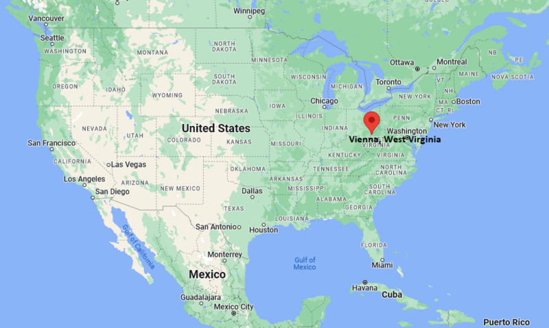
Vienna Map, West Virginia, USA
Where is Vienna?: The Google Map showing the location of Vienna in the U.S. state of West Virginia.
Where is Vienna Located?
Vienna is a city located in theWood County of West Virginia, United States. Vienna lies between 43.7153482 Degrees North latitudes and 72.307869 Degrees West longitudes. According to 2020 U.S.census, the population of Vienna city is 10652 people and the city has a total area of 3.96 sq mi. The city has numerous parks and recreational facilities.
Most Viewed US Maps
| USA Sttae Map | USA Region Map | USA Road Map |
| USA County Map | Where is USA in World Map? | US ZIP Code Map |
| USA Time Zones Map | US State and Capitals Map | USA Physical Map |
Find 4,400+ U.S. Cities by State - Explore Their Locations and Get Detailed Information
Vienna, West Virginia Quick Facts
| Attribute | Details |
|---|---|
| City | Vienna |
| County | Wood County |
| State | West Virginia |
| State Capital | Charleston |
| US Region | Appalachian Region |
| Latitude | 39.3270° N |
| Longitude | 81.5485° W |
| Elevation | Approximately 610 ft (186 m) |
| Land Area | 3.6 sq mi |
| Water Area | 0.0 sq mi |
| Total Area | 3.6 sq mi |
| Population (2020 Census) | 10,749 |
| Population Density | Approximately 2,990 per sq mi |
| ZIP Code | 26105 |
| Area Code | 304 |
| Time Zone Standard | Eastern Standard Time (EST), UTC−5 |
| Time Zone Daylight | Eastern Daylight Time (EDT), UTC−4 |
| Currency | United States Dollar (USD) |
| FIPS Code | 54-83548 |
| Community Type | City |
Transportation and Connectivity in Vienna, West Virginia
| Transportation | Details |
|---|---|
| Airport Name | Mid-Ohio Valley Regional Airport |
| IATA Code | PKB |
| Regional Airport | Yeager Airport in Charleston |
| Port | Ohio River transportation access |
| Major Highways | Interstate 77, US Route 50, US Route 21, West Virginia Route 14 |
| Train/Amtrak Service | Amtrak service available through regional stations |
| Local Transit Service | Mid-Ohio Valley Transit Authority |
- Interstate 77 — Major north-south interstate connecting Vienna with Parkersburg, Charleston, and Ohio communities.
- US Route 50 — Regional highway connecting western West Virginia with Ohio and surrounding areas.
- West Virginia Route 14 — Provides local connections throughout Wood County.
Top Places to Visit in Vienna, West Virginia
| Landmark Name | Type |
|---|---|
| Jackson Park | Community Park |
| Grand Central Mall | Shopping Center |
| Hocking Valley Scenic Railway Area | Railroad Attraction |
| Oil and Gas Museum | History Museum |
| Blacker's Mill Covered Bridge | Historic Bridge |
| Blennerhassett Island Historical State Park | State Park |
| Fort Boreman Park | Historic Park |
| North Bend State Park | State Park |
| Ohio River | Natural Landmark |
| Point Park | Riverfront Park |
Driving Distances from Vienna, West Virginia to Nearby Cities
| City | State | Distance (mi) | Approx. Drive Time |
|---|---|---|---|
| Parkersburg | West Virginia | 5 mi | 10 minutes |
| Marietta | Ohio | 15 mi | 20 minutes |
| Athens | Ohio | 45 mi | 55 minutes |
| Morgantown | West Virginia | 100 mi | 1 hour 45 minutes |
| Charleston | West Virginia | 100 mi | 1 hour 45 minutes |
| Columbus | Ohio | 110 mi | 1 hour 45 minutes |
| Pittsburgh | Pennsylvania | 170 mi | 3 hours |
| Cincinnati | Ohio | 150 mi | 2 hours 30 minutes |
| Cleveland | Ohio | 200 mi | 3 hours 15 minutes |
| Washington, DC | District of Columbia | 300 mi | 5 hours |
Colleges and Universities Near Vienna, West Virginia
| Institution Name | Type | Level | Notable For |
|---|---|---|---|
| West Virginia University at Parkersburg | Public | College | Associate degrees, workforce training, and transfer programs |
| Marietta College | Private | College | Liberal arts, sciences, business, and professional programs |
| Ohio Valley University | Private | University | Professional and undergraduate programs |
| West Virginia University | Public | University | Research, engineering, business, agriculture, and health sciences |
| Wood County Schools | Public | K–12 District | Local public education |
Waterbodies Near Vienna, West Virginia
Ohio River, Little Kanawha River, Hughes River, Worthington Creek, and nearby Wood County waterways
Golf Courses and Stadiums Near Vienna
Golf Courses: Worthington Golf Club, Parkersburg Country Club, and nearby Mid-Ohio Valley golf facilities. Stadiums: Stadium Field, West Virginia University at Parkersburg athletic facilities, and local community sports fields.
Key Landmarks and Places to Visit in Vienna, West Virginia
| Landmark Name | Type |
|---|---|
| Grand Central Mall | Shopping Center |
| Jackson Park | Community Park |
| Oil and Gas Museum | History Museum |
| Blennerhassett Island Historical State Park | State Park |
| Fort Boreman Park | Historic Park |
| North Bend State Park | State Park |
| Ohio River | Natural Landmark |
| Point Park | Riverfront Park |
| Blacker's Mill Covered Bridge | Historic Bridge |
| Mid-Ohio Valley Players Theatre | Performing Arts Venue |
Vienna, West Virginia — Key Historical Facts
- The Vienna area was originally inhabited by Indigenous peoples who lived along the Ohio River valley.
- The community was settled in the early 19th century and developed along important river transportation routes.
- Vienna was incorporated as a town in 1935 and later became a city in 1944.
- The city's growth was influenced by the oil, gas, glass, and manufacturing industries of the Mid-Ohio Valley.
- Vienna became an important suburban community within the Parkersburg metropolitan area.
- Today, Vienna is known for its parks, shopping centers, Ohio River location, and access to historical and outdoor attractions in the Mid-Ohio Valley.
References
- United States Census Bureau
- City of Vienna Official Website
- Wood County Official Website
- State of West Virginia Official Website
- West Virginia Tourism
West Virginia Maps and Info
| West Virginia Map | Counties in West Virginia | Cities in West Virginia |
| West Virginia Zipcodes | Airports in West Virginia | US Zip code Map |
| West Virginia Area Codes | West Virginia River Map | - |
- Where is Barboursville
- Where is Beckley
- Where is Blennerhassett
- Where is Bluefield
- Where is Bridgeport
- Where is Brookhaven
- Where is Buckhannon
- Where is Charles Town
- Where is Charleston
- Where is Cheat Lake
- Where is Clarksburg
- Where is Cross Lanes
- Where is Culloden
- Where is Dunbar
- Where is Elkins
- Where is Fairmont
- Where is Grafton
- Where is Huntington
- Where is Hurricane
- Where is Inwood
- Where is Keyser
- Where is Lewisburg
- Where is Martinsburg
- Where is Morgantown
- Where is Moundsville
- Where is New Martinsville
- Where is Nitro
- Where is Oak Hill
- Where is Parkersburg
- Where is Pea Ridge
- Where is Pleasant Valley
- Where is Point Pleasant
- Where is Princeton
- Where is Ranson corporation
- Where is Ravenswood
- Where is Ripley
- Where is Shady Spring
- Where is Shannondale
- Where is Sissonville
- Where is South Charleston
- Where is St. Albans
- Where is Teays Valley
- Where is Vienna
- Where is Weirton
- Where is Welch
- Where is Weston
- Where is Westover
- Where is Wheeling
- Where is Williamson
- Where is Williamstown