
Where is Ripley Located? - Ripley is a city located in the Jackson County of West Virginia, United States. Ripley lies between 40.6183158 Degrees North latitudes and 111.8162931 Degrees West longitudes.
Location Map of Ripley, West Virginia
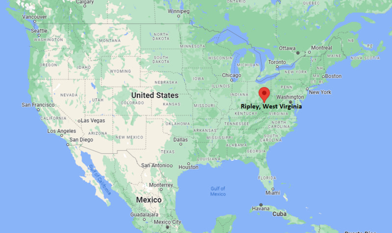
Ripley Map, West Virginia, USA
Where is Ripley?: The Google Map showing the location of Ripley in the U.S. state of West Virginia.
Where is Ripley Located?
Ripley is a city located in the Jackson County of West Virginia, United States. Ripley lies between 40.6183158 Degrees North latitudes and 111.8162931 Degrees West longitudes. According to 2020 U.S.census, the population of Ripley city is 3079 people and the city has a total area of 3.18 sq mi. The city has numerous parks and recreational facilities.
Most Viewed US Maps
| USA Sttae Map | USA Region Map | USA Road Map |
| USA County Map | Where is USA in World Map? | US ZIP Code Map |
| USA Time Zones Map | US State and Capitals Map | USA Physical Map |
Find 4,400+ U.S. Cities by State - Explore Their Locations and Get Detailed Information
Ripley, West Virginia Quick Facts
| Attribute | Details |
|---|---|
| City | Ripley |
| County | Jackson County |
| State | West Virginia |
| State Capital | Charleston |
| US Region | South |
| Latitude | 38.8211° N |
| Longitude | 81.7143° W |
| Elevation | 614 ft (187 m) |
| Land Area | 3.18 sq mi |
| Water Area | 0.11 sq mi |
| Total Area | 3.29 sq mi |
| Population (2020 Census) | 3,079 |
| Population Density | 968 per sq mi |
| ZIP Codes | 25271 |
| Area Code | 304 |
| Time Zone Standard | Eastern Standard Time (EST), UTC−5 |
| Time Zone Daylight | Eastern Daylight Time (EDT), UTC−4 |
| Currency | United States Dollar (USD) |
| FIPS Code | 54-68596 |
| Congressional District | West Virginia's 1st Congressional District |
Transportation and Connectivity in Ripley, West Virginia
| Transportation Type | Details |
|---|---|
| Airport Name | Mid-Ohio Valley Regional Airport |
| IATA Code | PKB |
| Port | No major port; inland location near Ohio River transportation routes |
| Major Highways | Interstate 77, U.S. Route 33, U.S. Route 21, West Virginia Route 62 |
| Train/Amtrak Service | No Amtrak station in Ripley; nearest passenger rail services are available in larger regional cities |
| Local Bus/Transit Service | Regional transportation services provide connections within Jackson County and nearby areas |
- Interstate 77 (I-77): Runs near Ripley and connects the city with Charleston, Parkersburg, and communities toward Ohio.
- U.S. Route 33: Provides east-west connections between Ripley and western West Virginia communities.
- U.S. Route 21: Historic route connecting Ripley with nearby towns and regional highways.
- West Virginia Route 62: Provides local access through Jackson County communities.
Top Places to Visit in Ripley, West Virginia
| Landmark Name | Type |
|---|---|
| Jackson County Courthouse | Historic Government Building |
| Ravenswood Museum | Museum |
| Ripley Historic District | Historic District |
| Jackson County Fairgrounds | Event Facility |
| Mill Creek | Natural Feature |
| North Bend State Park | State Park |
| Mountwood Park | Recreation Area |
| Charles Fork Lake | Lake and Recreation Area |
| West Virginia State Wildlife Center | Wildlife Attraction |
| Point Pleasant River Museum | Museum and Historic Attraction |
Driving Distances from Ripley, West Virginia to Nearby Cities
| City | State | Distance (mi) | Approx. Drive Time |
|---|---|---|---|
| Ravenswood | West Virginia | 18 mi | 25 minutes |
| Parkersburg | West Virginia | 45 mi | 50 minutes |
| Charleston | West Virginia | 60 mi | 1 hour |
| Point Pleasant | West Virginia | 55 mi | 1 hour |
| Athens | Ohio | 65 mi | 1 hour 20 minutes |
| Morgantown | West Virginia | 130 mi | 2 hours 30 minutes |
| Huntington | West Virginia | 95 mi | 1 hour 45 minutes |
| Columbus | Ohio | 150 mi | 2 hours 30 minutes |
| Cincinnati | Ohio | 150 mi | 2 hours 40 minutes |
| Pittsburgh | Pennsylvania | 180 mi | 3 hours 15 minutes |
Colleges and Universities Near Ripley, West Virginia
| Institution Name | Type | Level | Notable For |
|---|---|---|---|
| WVU Parkersburg | Public | Community College | Associate degrees, workforce training, and transfer programs |
| West Virginia University | Public | University | Research, engineering, medicine, and professional programs |
| Marshall University | Public | University | Health sciences, business, education, and athletics |
| University of Charleston | Private | University | Healthcare, business, and liberal arts programs |
| Jackson County Schools | Public | K–12 District | Primary and secondary education |
Waterbodies Near Ripley, West Virginia
Mill Creek, Ohio River, Charles Fork Lake, Evans Creek, Sandy Creek, and nearby waterways of Jackson County.
Golf Courses Near Ripley
Ravenswood Country Club, Mingo Bottom Golf Course, Big Bend Golf Course, Woodridge Golf Course, and Green Hills Country Club.
Ripley, West Virginia — Key Historical Facts
- Ripley was established in the early 19th century and became the county seat of Jackson County in 1835.
- The city was named after Harry Ripley, an early settler and local community figure.
- Ripley served as an important agricultural and trading center in central western West Virginia.
- The Battle of Ripley during the American Civil War period reflected the region's strategic importance during the conflict.
- Ripley has hosted the Jackson County Junior Fair, one of the region's long-running community events.
- The city continues to preserve its small-town heritage through historic buildings, local festivals, and community activities.
Stadiums and Sports Facilities Near Ripley
| Facility Name | Type | Location |
|---|---|---|
| Ripley High School Stadium | High School Sports Stadium | Ripley, West Virginia |
| Jackson County Recreation Center | Community Sports Facility | Ripley, West Virginia |
| WVU Parkersburg Athletic Facilities | College Sports Facility | Parkersburg, West Virginia |
| Joan C. Edwards Stadium | College Football Stadium | Huntington, West Virginia |
| Mountaineer Field at Milan Puskar Stadium | College Football Stadium | Morgantown, West Virginia |
References
- City of Ripley Official Website
- Jackson County, West Virginia Government
- U.S. Census Bureau
- West Virginia Tourism Office
- North Bend State Park - West Virginia State Parks
West Virginia Maps and Info
| West Virginia Map | Counties in West Virginia | Cities in West Virginia |
| West Virginia Zipcodes | Airports in West Virginia | US Zip code Map |
| West Virginia Area Codes | West Virginia River Map | - |
- Where is Barboursville
- Where is Beckley
- Where is Blennerhassett
- Where is Bluefield
- Where is Bridgeport
- Where is Brookhaven
- Where is Buckhannon
- Where is Charles Town
- Where is Charleston
- Where is Cheat Lake
- Where is Clarksburg
- Where is Cross Lanes
- Where is Culloden
- Where is Dunbar
- Where is Elkins
- Where is Fairmont
- Where is Grafton
- Where is Huntington
- Where is Hurricane
- Where is Inwood
- Where is Keyser
- Where is Lewisburg
- Where is Martinsburg
- Where is Morgantown
- Where is Moundsville
- Where is New Martinsville
- Where is Nitro
- Where is Oak Hill
- Where is Parkersburg
- Where is Pea Ridge
- Where is Pleasant Valley
- Where is Point Pleasant
- Where is Princeton
- Where is Ranson corporation
- Where is Ravenswood
- Where is Ripley
- Where is Shady Spring
- Where is Shannondale
- Where is Sissonville
- Where is South Charleston
- Where is St. Albans
- Where is Teays Valley
- Where is Vienna
- Where is Weirton
- Where is Welch
- Where is Weston
- Where is Westover
- Where is Wheeling
- Where is Williamson
- Where is Williamstown