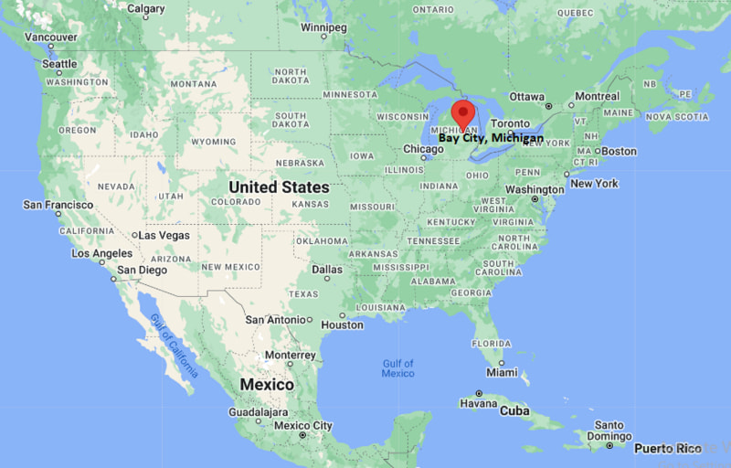
Where is Bay City Located? - Bay City is a city located in the Bay County of Michigan, United States. Bay City lies between 43.61216 Degrees North latitudes and -83.9199 Degrees West longitudes.
Location Map of Bay City, Michigan
Bay City Map, Michigan, USA
Where is Bay City?: The Google Map showing the location of Bay City in the U.S. state of Michigan.
Where is Bay City Located?
Bay City is a city located in the Bay County of Michigan, United States. Bay City lies at approximately 43.61216 Degrees North latitude and -83.9199 Degrees West longitude. According to the 2020 U.S. Census, the population of Bay City city is 32,661 people and the city has a total area of 11.201 sq mi. The city has numerous parks and recreational facilities.
Nearby Cities and Communities to Bay City, Michigan
Essexville, Michigan - 3 mi (5 km)
University Center, Michigan - 10 mi (16 km)
Saginaw, Michigan - 15 mi (24 km)
Midland, Michigan - 20 mi (32 km)
Auburn, Michigan - 12 mi (19 km)
Pinconning, Michigan - 18 mi (29 km)
Frankenmuth, Michigan - 28 mi (45 km)
Mount Pleasant, Michigan - 38 mi (61 km)
Flint, Michigan - 52 mi (84 km)
Lansing, Michigan - 85 mi (137 km)
Bay City, Michigan Climate and Weather Overview
Month
Avg High
Avg Low
Avg Precipitation
January
29°F
16°F
2.1 in
April
57°F
36°F
2.8 in
July
81°F
61°F
3.0 in
October
60°F
42°F
2.5 in
Climate Attribute
Details
Climate Type
Humid Continental (Dfa)
Annual Rainfall
Approximately 31 inches
Annual Sunshine
Approximately 175 sunny days
Average Snowfall
40 inches annually
Main Weather Risks
Winter Storms, Lake-Effect Snow and Flooding
Driving Distances from Bay City, Michigan
Destination
Distance
Distance (km)
Drive Time
Essexville
3 mi
5 km
8 min
Auburn
12 mi
19 km
15 min
Saginaw
15 mi
24 km
20 min
Midland
20 mi
32 km
25 min
Pinconning
18 mi
29 km
20 min
Frankenmuth
28 mi
45 km
35 min
Mount Pleasant
38 mi
61 km
45 min
Flint
52 mi
84 km
1 hr
Lansing
85 mi
137 km
1 hr 30 min
Detroit
115 mi
185 km
2 hr
Transportation and Connectivity in Bay City, Michigan
Nearest Airport
MBS International Airport
IATA Code
MBS
Major Airport
MBS International Airport (MBS)
Major Highways
Interstate 75, U.S. Route 10, M-13 and M-25
Rail Service
Freight Rail Service
Public Transit
Bay Metro Transportation Authority (Bay Metro)
Bay City is located along the Saginaw River near Saginaw Bay and Lake Huron.
The city developed as a major lumber and shipbuilding center during the nineteenth century.
Manufacturing, healthcare, tourism and maritime activities contribute to the local economy.
Bay City is part of Michigan's Great Lakes Bay Region along with Midland and Saginaw.
The city is known for its waterfront, historic districts and annual festivals.
Key Landmarks and Places to Visit in Bay City, Michigan
Landmark
Type
Bay City State Park
State Park
Veterans Memorial Park
Riverfront Park
Downtown Bay City Historic District
Historic District
Delta College Planetarium
Science Center
USS Edson Naval Museum
Maritime Museum
Saginaw Valley Naval Ship Museum
Military Museum
Riverwalk Pier
Waterfront Attraction
Wenonah Park
Community Park
Colleges and Universities Near Bay City, Michigan
Institution
Type
Distance
Notable For
Delta College
Community College
10 mi
Transfer and technical programs
Saginaw Valley State University
Public University
12 mi
Business and science programs
Northwood University
Private University
20 mi
Business education
Central Michigan University
Public University
38 mi
Research and higher education
University of Michigan-Flint
Public University
52 mi
Healthcare and professional studies
Waterbodies in and Near Bay City, Michigan
Saginaw River, Saginaw Bay, Lake Huron, Kawkawlin River, Tobico Marsh, Quanicassee River, Shiawassee River, Tittabawassee River, Cass River and Pine River.
Golf Courses in and Near Bay City, Michigan
Bay Valley Golf Club, Green Hills Golf Course, Maple Leaf Golf Course, The Sawmill Golf Club, Currie Municipal Golf Course, Apple Mountain Golf Resort, Sandy Ridge Golf Course and White Birch Hills Golf Course.
Bay City, Michigan - Key Historical Facts
Bay City was incorporated as a city in 1865 during Michigan's lumber boom.
The city's economy grew rapidly through lumber milling, shipping and shipbuilding.
Large quantities of timber from northern Michigan passed through Bay City's sawmills.
Its location on the Saginaw River made it an important transportation and trade center.
The city later diversified into manufacturing and industrial production.
Today, Bay City is recognized for its maritime heritage, waterfront attractions and historic architecture.