
Where is Inkster Located? - Inkster is a city located in the Wayne County of Michigan, United States. Inkster lies between 48.0632864 Degrees North latitudes and 114.0726134 Degrees West longitudes.
Location Map of Inkster, Michigan
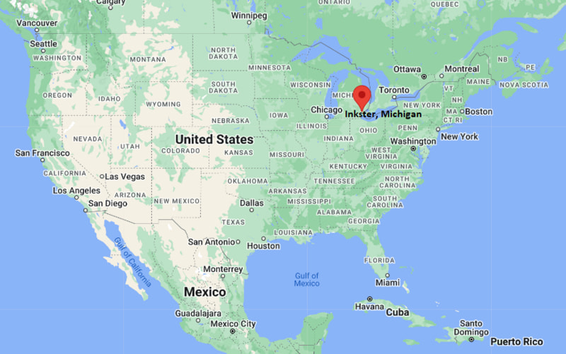
Inkster Map, Michigan, USA
Where is Inkster?: The Google Map showing the location of Inkster in the U.S. state of Michigan.
Where is Inkster Located?
Inkster is a city located in the Wayne County of Michigan, United States. Inkster lies between 48.0632864 Degrees North latitudes and 114.0726134 Degrees West longitudes. According to 2020 U.S.census, the population of Inkster city is 26088 people and the city has a total area of 6.25 sq mi. The city has numerous parks and recreational facilities.
Most Viewed US Maps
| USA Sttae Map | USA Region Map | USA Road Map |
| USA County Map | Where is USA in World Map? | US ZIP Code Map |
| USA Time Zones Map | US State and Capitals Map | USA Physical Map |
Find 4,400+ U.S. Cities by State - Explore Their Locations and Get Detailed Information
Inkster, Michigan Quick Facts
| Property | Information |
|---|---|
| City | Inkster |
| County | Wayne County |
| State | Michigan |
| State Capital | Lansing |
| US Region | Midwestern United States |
| Latitude | 42.2942° N |
| Longitude | 83.3099° W |
| Elevation | 617 ft (188 m) |
| Land Area | 6.26 sq mi |
| Water Area | 0.01 sq mi |
| Total Area | 6.27 sq mi |
| Population (latest Census year) | 25,404 (2020 Census) |
| Population Density | Approximately 4,058 per sq mi |
| ZIP Code | 48141 |
| Area Code | 313 |
| Time Zone Standard | Eastern Standard Time (EST, UTC−5) |
| Time Zone Daylight | Eastern Daylight Time (EDT, UTC−4) |
| Currency | US Dollar (USD) |
| FIPS Code | 26-40620 |
| Congressional District | Michigan's 12th Congressional District |
Nearby Cities to Inkster, Michigan
- Dearborn Heights, Michigan - North - 3 mi
- Westland, Michigan - West - 4 mi
- Garden City, Michigan - Northwest - 4 mi
- Romulus, Michigan - South - 5 mi
- Wayne, Michigan - West - 6 mi
- Taylor, Michigan - Southeast - 7 mi
- Livonia, Michigan - North - 8 mi
- Dearborn, Michigan - East - 8 mi
- Canton, Michigan - West - 11 mi
- Detroit, Michigan - East - 18 mi
Driving Distances from Inkster, Michigan
| City | State | Distance (mi) | Approx. Drive Time |
|---|---|---|---|
| Dearborn Heights | Michigan | 3 | 8 minutes |
| Westland | Michigan | 4 | 10 minutes |
| Garden City | Michigan | 4 | 10 minutes |
| Romulus | Michigan | 5 | 10 minutes |
| Wayne | Michigan | 6 | 12 minutes |
| Taylor | Michigan | 7 | 15 minutes |
| Livonia | Michigan | 8 | 15 minutes |
| Dearborn | Michigan | 8 | 18 minutes |
| Canton | Michigan | 11 | 20 minutes |
| Detroit | Michigan | 18 | 25 minutes |
Transportation and Connectivity in Inkster, Michigan
| Transportation | Details |
|---|---|
| Airport Name | Detroit Metropolitan Wayne County Airport |
| IATA Code | DTW |
| Port | Port of Detroit (regional) |
| Major Highways | Interstate 94, Interstate 275, Michigan Highway 153 (nearby) |
| Train/Amtrak Service | Nearest Amtrak station in Dearborn |
| Local Bus/Transit Service | SMART (Suburban Mobility Authority for Regional Transportation) |
- Interstates 94 and 275 provide convenient access to Detroit, Ann Arbor, Toledo, and the broader Metro Detroit region.
- Michigan Highway 153 (Ford Road) serves as an important east-west corridor connecting Inkster with neighboring communities.
- Detroit Metropolitan Wayne County Airport, approximately 7 miles south, offers extensive domestic and international air service.
- SMART bus routes connect Inkster with Detroit, Dearborn, Livonia, Westland, and other nearby communities.
- Inkster's central location within Metro Detroit provides residents with access to major employment centers, educational institutions, healthcare facilities, and cultural attractions.
What are top Places to Visit in Inkster, Michigan
| Landmark Name | Type |
|---|---|
| Inkster Valley Golf Club | Golf Course |
| Inkster City Park | Community Park |
| Leanna Hicks Public Library | Library |
| Heritage Park (Taylor) | Regional Park |
| Greenfield Village | Living History Museum |
| The Henry Ford Museum of American Innovation | Museum |
| Rouge Park | Urban Park |
| Detroit Historical Museum | History Museum |
| Lower Rouge Parkway | Nature Area |
| Wayne County Community Recreation Areas | Outdoor Recreation |
Colleges and Universities in Inkster, Michigan
| Institution Name | Type | Level | Notable For |
|---|---|---|---|
| Wayne County Community College District | Public | Community College | Associate degrees, workforce training, healthcare, and university transfer programs |
| University of Michigan–Dearborn | Public | University | Engineering, business, education, computer science, and research |
| Madonna University | Private | University | Nursing, education, business, and liberal arts programs |
| Schoolcraft College | Public | Community College | Career education, culinary arts, technical programs, and university transfer |
| Inkster Public Schools (Educational Services) | Public | K–12 Education | Primary and secondary educational services through regional school partnerships |
Waterbodies in Inkster, Michigan
Lower Rouge River, Rouge River, Detroit River, Newburgh Lake, Phoenix Lake, Belleville Lake, Hines Park Waterway, Nankin Lake
Golf Courses in Inkster, Michigan
Inkster Valley Golf Club, Fellows Creek Golf Club, Warren Valley Golf Course, Gateway Golf Club, Dearborn Hills Golf Course, Fox Hills Golf & Banquet Center
Inkster, Michigan — Key Historical Facts
- Inkster was established during the nineteenth century as a rural settlement and was named after Robert Inkster, an early railroad official.
- The community experienced significant growth during the early and mid-twentieth century as nearby automobile manufacturing expanded across the Detroit metropolitan area.
- Inkster officially became a city in 1964 and developed into a diverse residential community serving workers employed throughout Metro Detroit.
- Its proximity to Detroit Metropolitan Wayne County Airport and major interstate highways contributed to continued residential and commercial development.
- Today, Inkster is recognized for its strategic location in Wayne County, strong community identity, regional transportation access, and proximity to major educational, cultural, and employment centers.
References
Michigan Related Maps and Info
- Where is Allen Park
- Where is Allendale
- Where is Ann Arbor
- Where is Battle Creek
- Where is Bay City
- Where is Burton
- Where is Dearborn
- Where is Dearborn Heights
- Where is East Lansing
- Where is Eastpointe
- Where is Farmington Hills
- Where is Flint
- Where is Forest Hills
- Where is Garden City
- Where is Grand Rapids
- Where is Hamtramck
- Where is Holland
- Where is Holt
- Where is Inkster
- Where is Jackson
- Where is Kalamazoo
- Where is Kentwood
- Where is Lansing
- Where is Lincoln Park
- Where is Livonia
- Where is Madison Heights
- Where is Midland
- Where is Muskegon
- Where is Novi
- Where is Oak Park
- Where is Okemos
- Where is Pontiac
- Where is Port Huron
- Where is Portage
- Where is Rochester Hills
- Where is Romulus
- Where is Roseville
- Where is Royal Oak
- Where is Saginaw
- Where is Southfield
- Where is Southgate
- Where is St. Clair Shores
- Where is Sterling Heights
- Where is Taylor
- Where is Troy
- Where is Walker
- Where is Warren
- Where is Westland
- Where is Wyoming