
Where is Hamtramck Located? - Hamtramck is a city located in the Wayne County of Michigan, United States. Hamtramck lies between 46.4083362 Degrees North latitudes and 105.8405582 Degrees West longitudes.
Location Map of Hamtramck, Michigan
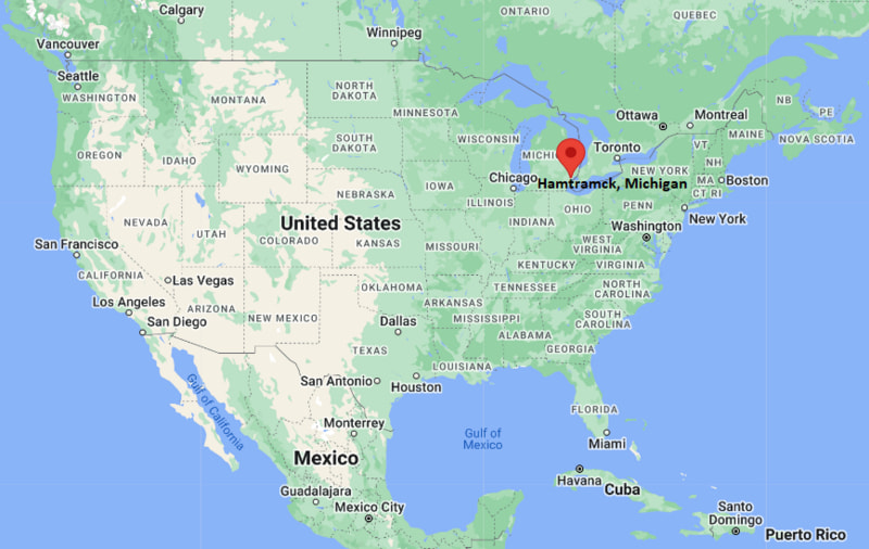
Hamtramck Map, Michigan, USA
Where is Hamtramck?: The Google Map showing the location of Hamtramck in the U.S. state of Michigan.
Where is Hamtramck Located?
Hamtramck is a city located in the Wayne County of Michigan, United States. Hamtramck lies between 46.4083362 Degrees North latitudes and 105.8405582 Degrees West longitudes. According to 2020 U.S.census, the population of Hamtramck city is 28433 people and the city has a total area of 2.1 sq mi. The city has numerous parks and recreational facilities.
Most Viewed US Maps
| USA Sttae Map | USA Region Map | USA Road Map |
| USA County Map | Where is USA in World Map? | US ZIP Code Map |
| USA Time Zones Map | US State and Capitals Map | USA Physical Map |
Find 4,400+ U.S. Cities by State - Explore Their Locations and Get Detailed Information
Hamtramck, Michigan Quick Facts
| Property | Information |
|---|---|
| City | Hamtramck |
| County | Wayne County |
| State | Michigan |
| State Capital | Lansing |
| US Region | Midwestern United States |
| Latitude | 42.3928°N |
| Longitude | 83.0496°W |
| Elevation | 623 ft (190 m) |
| Land Area | 2.09 sq mi |
| Water Area | 0.00 sq mi |
| Total Area | 2.09 sq mi |
| Population (latest Census year) | 28,433 (Census 2020) |
| Population Density | Approximately 13,600 per sq mi |
| ZIP Codes | 48211, 48212 |
| Area Code | 313 |
| Time Zone Standard | Eastern Standard Time (EST, UTC−5) |
| Time Zone Daylight | Eastern Daylight Time (EDT, UTC−4) |
| Currency | US Dollar (USD) |
| FIPS Code | 26-36220 |
| Congressional District | Michigan's 13th Congressional District |
Nearby Cities to Hamtramck, Michigan
- Detroit, Michigan — 3 mi South
- Highland Park, Michigan — 2 mi Northwest
- Hazel Park, Michigan — 6 mi North
- Ferndale, Michigan — 7 mi Northwest
- Royal Oak, Michigan — 9 mi North
- Warren, Michigan — 9 mi Northeast
- Dearborn, Michigan — 12 mi Southwest
- Southfield, Michigan — 13 mi Northwest
- Madison Heights, Michigan — 10 mi North
- Grosse Pointe Park, Michigan — 10 mi East
Driving Distances from Hamtramck, Michigan
| City | State | Distance (mi) | Approx. Drive Time |
|---|---|---|---|
| Detroit | Michigan | 3 | 10 minutes |
| Highland Park | Michigan | 2 | 5 minutes |
| Hazel Park | Michigan | 6 | 15 minutes |
| Ferndale | Michigan | 7 | 15 minutes |
| Royal Oak | Michigan | 9 | 20 minutes |
| Warren | Michigan | 9 | 20 minutes |
| Dearborn | Michigan | 12 | 25 minutes |
| Southfield | Michigan | 13 | 25 minutes |
| Ann Arbor | Michigan | 43 | 50 minutes |
| Lansing | Michigan | 92 | 1 hour 30 minutes |
Transportation and Connectivity in Hamtramck, Michigan
| Transportation | Details |
|---|---|
| Airport Name | Detroit Metropolitan Wayne County Airport; Coleman A. Young International Airport |
| IATA Code | DTW (Detroit Metropolitan), DET (Coleman A. Young) |
| Port | Port of Detroit (nearby) |
| Major Highways | Interstate 75, Interstate 94, Interstate 96 (nearby), M-8 (Davison Freeway) |
| Train/Amtrak Service | Nearest Amtrak station at Detroit (New Center) |
| Local Bus/Transit Service | Detroit Department of Transportation (DDOT) and SMART Bus |
- Interstate 75 provides direct access to downtown Detroit, Flint, and Toledo.
- Interstate 94 connects Hamtramck with Detroit Metropolitan Airport, Ann Arbor, and Port Huron.
- Interstate 96 offers regional access across the Detroit metropolitan area.
- M-8 (Davison Freeway) links Hamtramck with Interstate 96 and Interstate 75.
- DDOT and SMART buses provide convenient public transportation throughout Hamtramck and Metro Detroit.
What are top Places to Visit in Hamtramck, Michigan
| Landmark Name | Type |
|---|---|
| Hamtramck Historical Museum | Museum |
| Jos. Campau Historic District | Historic District |
| Pope Park | City Park |
| Veterans Memorial Park | Community Park |
| Hamtramck Disneyland | Folk Art Installation |
| St. Florian Catholic Church | Historic Church |
| Planet Ant Theatre | Theater |
| Detroit Institute of Arts | Art Museum |
| Motown Museum | Museum |
| Belle Isle Park | Island Park |
Colleges and Universities in Hamtramck, Michigan
| Institution Name | Type | Level | Notable For |
|---|---|---|---|
| Wayne State University | Public | University | Research and medical education |
| College for Creative Studies | Private | University | Art and design programs |
| University of Detroit Mercy | Private | University | Health sciences, law, and engineering |
| Wayne County Community College District | Public | Community College | Transfer and workforce education |
| Hamtramck Public Schools | Public | K–12 District | Public education serving Hamtramck |
Waterbodies in Hamtramck, Michigan
Detroit River, Lake St. Clair, Rouge River, Conner Creek, Fox Creek, Bloody Run Creek, Belle Isle Channel, Erie Canal Harbor, Clinton River, Lake Erie
Golf Courses in Hamtramck, Michigan
Chandler Park Golf Course, Rackham Golf Course, Detroit Golf Club, Rouge Park Golf Course, Warren Valley Golf Course, Plum Hollow Country Club, Red Run Golf Club, Sycamore Hills Golf Club
Hamtramck, Michigan — Key Historical Facts
- Hamtramck was settled in the late eighteenth century and was originally a farming community before becoming an industrial center during Detroit's rapid expansion.
- The city experienced significant growth in the early twentieth century when the Dodge Main automobile plant attracted thousands of workers, particularly Polish immigrants.
- Hamtramck became known as one of the nation's most culturally diverse communities, with successive waves of immigrants from Europe, the Middle East, Asia, and Africa shaping its identity.
- Following the closure of the Dodge Main plant, the city successfully diversified its economy while preserving its historic neighborhoods and vibrant multicultural traditions.
- Today, Hamtramck is recognized for its international cuisine, diverse population, annual festivals, historic churches and mosques, and thriving arts and music scene.
References
Michigan Related Maps and Info
- Where is Allen Park
- Where is Allendale
- Where is Ann Arbor
- Where is Battle Creek
- Where is Bay City
- Where is Burton
- Where is Dearborn
- Where is Dearborn Heights
- Where is East Lansing
- Where is Eastpointe
- Where is Farmington Hills
- Where is Flint
- Where is Forest Hills
- Where is Garden City
- Where is Grand Rapids
- Where is Hamtramck
- Where is Holland
- Where is Holt
- Where is Inkster
- Where is Jackson
- Where is Kalamazoo
- Where is Kentwood
- Where is Lansing
- Where is Lincoln Park
- Where is Livonia
- Where is Madison Heights
- Where is Midland
- Where is Muskegon
- Where is Novi
- Where is Oak Park
- Where is Okemos
- Where is Pontiac
- Where is Port Huron
- Where is Portage
- Where is Rochester Hills
- Where is Romulus
- Where is Roseville
- Where is Royal Oak
- Where is Saginaw
- Where is Southfield
- Where is Southgate
- Where is St. Clair Shores
- Where is Sterling Heights
- Where is Taylor
- Where is Troy
- Where is Walker
- Where is Warren
- Where is Westland
- Where is Wyoming