
Where is Forest Hills Located? - Forest Hills is a city located in the Allegheny County of Michigan, United States. Forest Hills lies between 45.6750915 Degrees North latitudes and 111.1808618 Degrees West longitudes.
Location Map of Forest Hills, Michigan
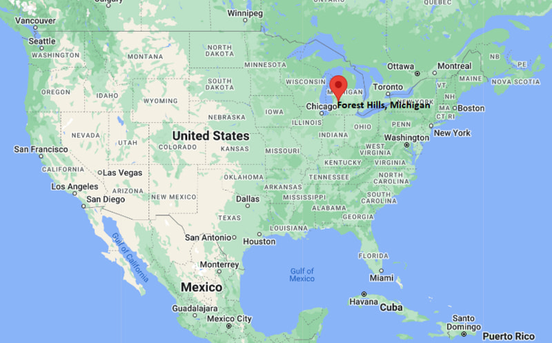
Forest Hills Map, Michigan, USA
Where is Forest Hills?: The Google Map showing the location of Forest Hills in the U.S. state of Michigan.
Where is Forest Hills Located?
Forest Hills is a city located in the Allegheny County of Michigan, United States. Forest Hills lies between 45.6750915 Degrees North latitudes and 111.1808618 Degrees West longitudes. According to 2020 U.S.census, the population of Forest Hills city is 28573 people and the city has a total area of 49.27 sq mi. The city has numerous parks and recreational facilities.
Most Viewed US Maps
| USA Sttae Map | USA Region Map | USA Road Map |
| USA County Map | Where is USA in World Map? | US ZIP Code Map |
| USA Time Zones Map | US State and Capitals Map | USA Physical Map |
Find 4,400+ U.S. Cities by State - Explore Their Locations and Get Detailed Information
Forest Hills, Michigan Quick Facts
| Property | Information |
|---|---|
| City | Forest Hills (Census-designated place) |
| County | Kent County |
| State | Michigan |
| State Capital | Lansing |
| US Region | Midwestern United States |
| Latitude | 42.9419° N |
| Longitude | 85.4897° W |
| Elevation | 722 ft (220 m) |
| Land Area | 7.33 sq mi |
| Water Area | 0.12 sq mi |
| Total Area | 7.45 sq mi |
| Population (latest Census year) | 28,975 (2020 Census) |
| Population Density | 3,953 per sq mi |
| ZIP Codes | 49506, 49512, 49525, 49546 |
| Area Code | 616 |
| Time Zone Standard | Eastern Standard Time (EST, UTC−5) |
| Time Zone Daylight | Eastern Daylight Time (EDT, UTC−4) |
| Currency | US Dollar (USD) |
| FIPS Code | 26-29280 |
| Congressional District | 3rd Congressional District |
Nearby Cities to Forest Hills, Michigan
- Grand Rapids, Michigan — 8 mi West
- Kentwood, Michigan — 6 mi South
- East Grand Rapids, Michigan — 4 mi West
- Cascade Township, Michigan — 2 mi South
- Ada, Michigan — 4 mi East
- Lowell, Michigan — 14 mi East
- Rockford, Michigan — 15 mi North
- Wyoming, Michigan — 12 mi Southwest
- Walker, Michigan — 13 mi West
- Grandville, Michigan — 15 mi Southwest
Driving Distances from Forest Hills, Michigan
| City | State | Distance (mi) | Approx. Drive Time |
|---|---|---|---|
| Cascade Township | Michigan | 2 | 5 min |
| East Grand Rapids | Michigan | 4 | 8 min |
| Ada | Michigan | 4 | 8 min |
| Kentwood | Michigan | 6 | 12 min |
| Grand Rapids | Michigan | 8 | 15 min |
| Wyoming | Michigan | 12 | 18 min |
| Walker | Michigan | 13 | 20 min |
| Lowell | Michigan | 14 | 20 min |
| Rockford | Michigan | 15 | 22 min |
| Lansing | Michigan | 67 | 1 hr 10 min |
Transportation and Connectivity in Forest Hills, Michigan
| Category | Information |
|---|---|
| Airport Name | Gerald R. Ford International Airport |
| IATA Code | GRR |
| Port | Port of Grand Rapids (regional freight facilities) |
| Major Highways | Interstate 96, M-21, M-37, East Beltline Avenue (M-44) |
| Train/Amtrak Service | Nearest Amtrak station is Grand Rapids |
| Local Bus/Transit Service | The Rapid public transit system |
- Interstate 96 - Primary freeway providing access to Grand Rapids, Lansing, Detroit and Muskegon.
- M-21 (Fulton Street) - Major east-west corridor connecting Forest Hills with downtown Grand Rapids and Lowell.
- East Beltline Avenue (M-44) - Important north-south route serving residential, retail and business districts.
- M-37 (East Beltline/Broadmoor Avenue) - Connects the community with Kentwood, Grand Rapids and surrounding areas.
What are top Places to Visit in Forest Hills, Michigan
| Landmark Name | Type |
|---|---|
| Frederik Meijer Gardens & Sculpture Park | Botanical Garden |
| Cascade Peace Park | Nature Preserve |
| Roselle Park | Community Park |
| Ada Township Park | Recreation Area |
| Thornapple River | Natural Attraction |
| Grand Rapids Children's Museum | Museum |
| John Ball Zoo | Zoo |
| Downtown Ada | Shopping & Dining District |
| Knapp's Corner | Shopping Center |
| Crahen Valley Park | Nature Park |
Colleges and Universities in Forest Hills, Michigan
| Institution Name | Type | Level | Notable For |
|---|---|---|---|
| Calvin University | Private | University | Liberal arts, business and engineering programs |
| Aquinas College | Private | College | Liberal arts, education and sustainability studies |
| Grand Rapids Community College | Public | Community College | Transfer, technical and workforce education |
| Forest Hills Public Schools | Public | K–12 District | Highly rated public education system |
Waterbodies in Forest Hills, Michigan
Thornapple River, Grand River, Reeds Lake, Fisk Lake, Cascade Lake, Ada Township Ponds, Coldbrook Creek, Plaster Creek
Golf Courses in Forest Hills, Michigan
Watermark Country Club, Egypt Valley Country Club, Thousand Oaks Golf Club, Cascade Hills Country Club, Quail Ridge Golf Club, The Mines Golf Course
Forest Hills, Michigan — Key Historical Facts
- Forest Hills developed as a residential community in eastern Kent County during the mid-twentieth century as suburban growth spread outward from Grand Rapids.
- The area expanded rapidly after World War II with new neighborhoods, schools, and commercial development serving the growing metropolitan population.
- The creation and continued expansion of Forest Hills Public Schools contributed significantly to the community's reputation for educational excellence.
- Its proximity to major employers, Gerald R. Ford International Airport, and the Grand Rapids business district encouraged sustained residential and economic growth.
- Today, Forest Hills is recognized as one of the most desirable suburban communities in the Grand Rapids metropolitan area, offering highly rated schools, parks, shopping districts, and convenient access to recreation along the Thornapple River.
References
Michigan Related Maps and Info
- Where is Allen Park
- Where is Allendale
- Where is Ann Arbor
- Where is Battle Creek
- Where is Bay City
- Where is Burton
- Where is Dearborn
- Where is Dearborn Heights
- Where is East Lansing
- Where is Eastpointe
- Where is Farmington Hills
- Where is Flint
- Where is Forest Hills
- Where is Garden City
- Where is Grand Rapids
- Where is Hamtramck
- Where is Holland
- Where is Holt
- Where is Inkster
- Where is Jackson
- Where is Kalamazoo
- Where is Kentwood
- Where is Lansing
- Where is Lincoln Park
- Where is Livonia
- Where is Madison Heights
- Where is Midland
- Where is Muskegon
- Where is Novi
- Where is Oak Park
- Where is Okemos
- Where is Pontiac
- Where is Port Huron
- Where is Portage
- Where is Rochester Hills
- Where is Romulus
- Where is Roseville
- Where is Royal Oak
- Where is Saginaw
- Where is Southfield
- Where is Southgate
- Where is St. Clair Shores
- Where is Sterling Heights
- Where is Taylor
- Where is Troy
- Where is Walker
- Where is Warren
- Where is Westland
- Where is Wyoming