Written and Fact-checked by Whereig Editors | Updated On: May 01, 2026, 13:37 ET
Map of Allegheny County - Allegheny County is a county located in the U.S. state of Pennsylvania. Allegheny County Map showing cities, highways, important places and water bodies. Get Where is Allegheny County located in the map, major cities in Allegheny county, population, areas, and places of interest.
Map of Allegheny County, Pennsylvania
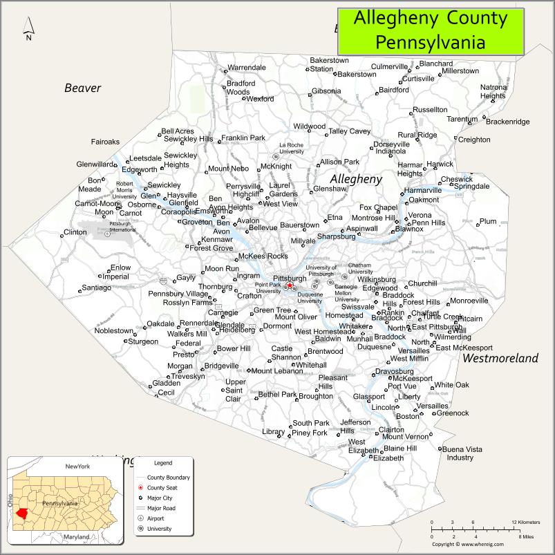
About Allegheny County Map, Pennsylvania: The map showing the county boundary, county seat, major cities, highways, water bodies and neighbouring counties.
Pennsylvania Related Links
About Allegheny County, Pennsylvania
Allegheny County is a county located in the U.S. state of Pennsylvania. It's county seat is Pittsburgh. As per 2020 census, the population of Allegheny County is 1238090 people and population density is square miles. According to the United States Census Bureau, the county has a total area of 745 sq mi (1,930 km2). Allegheny County was established on 1788.
Facts about Allegheny County, Pennsylvania
| Country | United States |
| State | Pennsylvania |
| Region | Western Pennsylvania |
| County Seat | Pittsburgh |
| Named After | Allegheny River |
| Established | 1788 |
| Organized | 1788 |
| Coordinates | 40.4689° N, 79.9814° W |
| Total Area | 745 sq mi |
| Land Area | 730 sq mi |
| Water Area | 15 sq mi |
| Population (2020 Census) | 1,250,578 |
| Population Rank | Second most populous county in Pennsylvania |
| Major City | Pittsburgh |
| Main Industries | Healthcare, Education, Technology, Finance, Manufacturing |
| Major Airport | Pittsburgh International Airport (PIT) |
| Time Zone | Eastern Time (UTC−05:00) |
| Known For | Pittsburgh skyline, Steel industry heritage, Three Rivers |
| Website | https://www.alleghenycounty.us |
Top Attractions in Allegheny County, Pennsylvania
- Pittsburgh Downtown – Cultural, dining, and business center.
- Point State Park – Rivers confluence and city views.
- Carnegie Museum of Natural History – Dinosaurs and science exhibits.
- Carnegie Museum of Art – Modern and contemporary art.
- Phipps Conservatory and Botanical Gardens – Glasshouse gardens.
- Andy Warhol Museum – Pop art and modern culture.
- Duquesne Incline – Historic hillside cable car.
- PNC Park – Pittsburgh Pirates baseball stadium.
- Heinz History Center – Western Pennsylvania history.
- Mount Washington Overlook – Skyline viewpoints.
- Strip District – Markets, food, and shopping.
- Rivers Casino Pittsburgh – Gaming and entertainment.
Cities & Towns in Allegheny County, Pennsylvania
Pittsburgh, McKeesport, Monroeville, Bethel Park, West Mifflin, Upper St. Clair, Mount Lebanon, Robinson Township, Oakdale, North Versailles, Penn Hills, Wilkinsburg, Carnegie, Dormont, Heidelberg, Sewickley, Avalon, Forest Hills, Baldwin, West View
- Adams County Map
- Allegheny County Map
- Armstrong County Map
- Beaver County Map
- Bedford County Map
- Berks County Map
- Blair County Map
- Bradford County Map
- Bucks County Map
- Butler County Map
- Cambria County Map
- Cameron County Map
- Carbon County Map
- Centre County Map
- Chester County Map
- Clarion County Map
- Clearfield County Map
- Clinton County Map
- Columbia County Map
- Crawford County Map
- Cumberland County Map
- Dauphin County Map
- Delaware County Map
- Elk County Map
- Erie County Map
- Fayette County Map
- Forest County Map
- Franklin County Map
- Fulton County Map
- Greene County Map
- Huntingdon County Map
- Indiana County Map
- Jefferson County Map
- Juniata County Map
- Lackawanna County Map
- Lancaster County Map
- Lawrence County Map
- Lebanon County Map
- Lehigh County Map
- Luzerne County Map
- Lycoming County Map
- McKean County Map
- Mercer County Map
- Mifflin County Map
- Monroe County Map
- Montgomery County Map
- Montour County Map
- Northampton County Map
- Northumberland County Map
- Perry County Map
- Philadelphia County Map
- Pike County Map
- Potter County Map
- Schuylkill County Map
- Snyder County Map
- Somerset County Map
- Sullivan County Map
- Susquehanna County Map
- Tioga County Map
- Union County Map
- Venango County Map
- Warren County Map
- Washington County Map
- Wayne County Map
- Westmoreland County Map
- Wyoming County Map
- York County Map
- Alabama Counties
- Alaska boroughs
- Arizona Counties
- Arkansas Counties
- California County Map
- Colorado Counties
- Connecticut Counties
- Delaware Counties
- Florida County Map
- Georgia County Map
- Hawaii Counties
- Idaho Counties
- Illinois Counties
- Indiana Counties
- Iowa Counties
- Kansas Counties
- Kentucky Counties
- Louisiana Counties
- Maine Counties
- Maryland Counties
- Massachusetts Counties
- Michigan County Map
- Minnesota Counties
- Mississippi Counties
- Missouri Counties
- Montana Counties
- Nebraska Counties
- Nevada Counties
- New York Counties
- New Hampshire Counties
- New Jersey Counties
- New Mexico Counties
- North Carolina Counties
- North Dakota Counties
- Ohio County Map
- Oklahoma Counties
- Oregon Counties
- Pennsylvania Counties
- Rhode Island Counties
- South Carolina Counties
- South Dakota Counties
- Map of Tennessee
- Texas County Map
- Utah Counties
- Vermont Counties
- Virginia Counties
- Washington Counties
- West Virginia Counties
- Wisconsin Counties
- Wyoming Counties