Written and Fact-checked by Whereig Editors | Updated On: May 01, 2026, 13:37 ET
Map of Crawford County - Crawford County is a county located in the U.S. state of Pennsylvania. Crawford County Map showing cities, highways, important places and water bodies. Get Where is Crawford County located in the map, major cities in Crawford county, population, areas, and places of interest.
Map of Crawford County, Pennsylvania
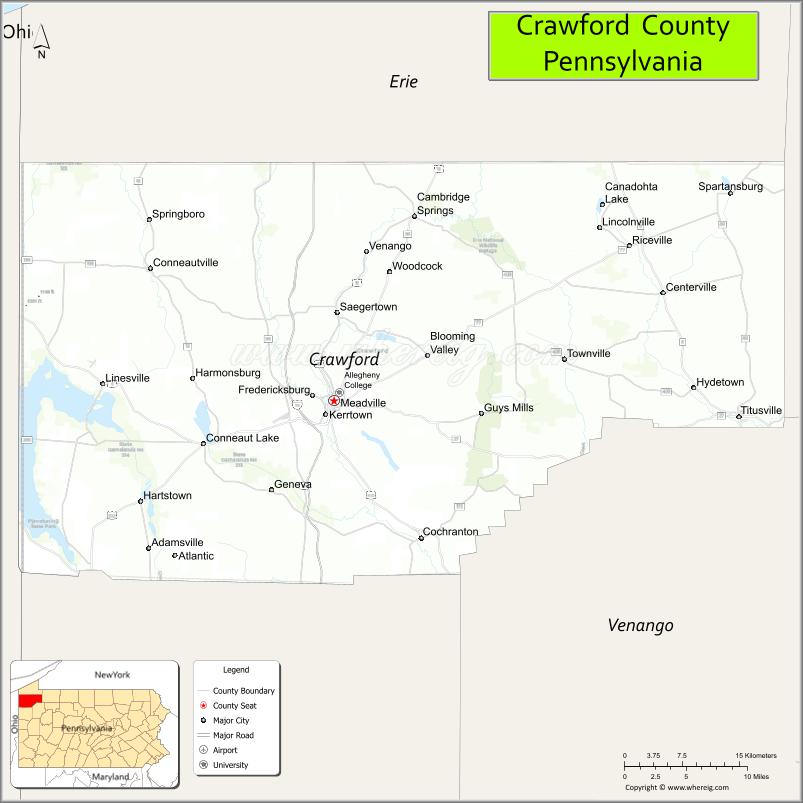
About Crawford County Map, Pennsylvania: The map showing the county boundary, county seat, major cities, highways, water bodies and neighbouring counties.
Pennsylvania Related Links
About Crawford County, Pennsylvania
Crawford County is a county located in the U.S. state of Pennsylvania. It's county seat is Meadville. As per 2020 census, the population of Crawford County is 83351 people and population density is square miles. According to the United States Census Bureau, the county has a total area of 1,038 sq mi (2,688 km2). Crawford County was established on 1800.
Facts about Crawford County, Pennsylvania
| Country | United States |
| State | Pennsylvania |
| Region | Northwestern Pennsylvania |
| County Seat | Meadville |
| Named After | Colonel William Crawford |
| Established | 1800 |
| Organized | 1800 |
| Coordinates | 41.6842° N, 80.1064° W |
| Total Area | 1,043 sq mi |
| Land Area | 1,012 sq mi |
| Water Area | 31 sq mi |
| Population (2020 Census) | 86,604 |
| Population Rank | Mid-sized county in Pennsylvania |
| Major City | Meadville |
| Main Industries | Manufacturing, Education, Agriculture, Healthcare |
| Major Airport | Port Meadville Airport (GKJ) |
| Time Zone | Eastern Time (UTC−05:00) |
| Known For | Pymatuning Reservoir, Crawford County Fair, Outdoor recreation |
| Website | https://www.crawfordcountypa.net |
Top Attractions in Crawford County, Pennsylvania
- Pymatuning State Park – Large lake and outdoor recreation.
- Linesville Spillway – Famous fish viewing spot.
- Meadville Downtown Historic District – Shops and historic buildings.
- Baldwin-Reynolds House Museum – Victorian-era home museum.
- Drake Well Museum (nearby) – Birthplace of the oil industry.
- Woodcock Lake Park – Boating, fishing, and trails.
- Ernst Conservation Seed Orchard – Native plants and walking paths.
- Cambridge Springs Historic District – Spa-town history and charm.
- Allegheny College Campus – Historic college setting.
- Conneaut Lake Park – Classic lakeside amusement park.
- Crawford County Fairgrounds – Annual fair and events.
- French Creek – Fishing and paddling stream.
Cities & Towns in Crawford County, Pennsylvania
Meadville, Titusville, Cambridge Springs, Conneaut Lake, Saegertown, Franklin Township, Hydetown, Hartstown, Cochranton, Linesville, Randolph, Spartansburg, Guys Mills
- Adams County Map
- Allegheny County Map
- Armstrong County Map
- Beaver County Map
- Bedford County Map
- Berks County Map
- Blair County Map
- Bradford County Map
- Bucks County Map
- Butler County Map
- Cambria County Map
- Cameron County Map
- Carbon County Map
- Centre County Map
- Chester County Map
- Clarion County Map
- Clearfield County Map
- Clinton County Map
- Columbia County Map
- Crawford County Map
- Cumberland County Map
- Dauphin County Map
- Delaware County Map
- Elk County Map
- Erie County Map
- Fayette County Map
- Forest County Map
- Franklin County Map
- Fulton County Map
- Greene County Map
- Huntingdon County Map
- Indiana County Map
- Jefferson County Map
- Juniata County Map
- Lackawanna County Map
- Lancaster County Map
- Lawrence County Map
- Lebanon County Map
- Lehigh County Map
- Luzerne County Map
- Lycoming County Map
- McKean County Map
- Mercer County Map
- Mifflin County Map
- Monroe County Map
- Montgomery County Map
- Montour County Map
- Northampton County Map
- Northumberland County Map
- Perry County Map
- Philadelphia County Map
- Pike County Map
- Potter County Map
- Schuylkill County Map
- Snyder County Map
- Somerset County Map
- Sullivan County Map
- Susquehanna County Map
- Tioga County Map
- Union County Map
- Venango County Map
- Warren County Map
- Washington County Map
- Wayne County Map
- Westmoreland County Map
- Wyoming County Map
- York County Map
- Alabama Counties
- Alaska boroughs
- Arizona Counties
- Arkansas Counties
- California County Map
- Colorado Counties
- Connecticut Counties
- Delaware Counties
- Florida County Map
- Georgia County Map
- Hawaii Counties
- Idaho Counties
- Illinois Counties
- Indiana Counties
- Iowa Counties
- Kansas Counties
- Kentucky Counties
- Louisiana Counties
- Maine Counties
- Maryland Counties
- Massachusetts Counties
- Michigan County Map
- Minnesota Counties
- Mississippi Counties
- Missouri Counties
- Montana Counties
- Nebraska Counties
- Nevada Counties
- New York Counties
- New Hampshire Counties
- New Jersey Counties
- New Mexico Counties
- North Carolina Counties
- North Dakota Counties
- Ohio County Map
- Oklahoma Counties
- Oregon Counties
- Pennsylvania Counties
- Rhode Island Counties
- South Carolina Counties
- South Dakota Counties
- Map of Tennessee
- Texas County Map
- Utah Counties
- Vermont Counties
- Virginia Counties
- Washington Counties
- West Virginia Counties
- Wisconsin Counties
- Wyoming Counties