Written and Fact-checked by Whereig Editors | Updated On: May 01, 2026, 13:37 ET
Map of Franklin County - Franklin County is a county located in the U.S. state of Pennsylvania. Franklin County Map showing cities, highways, important places and water bodies. Get Where is Franklin County located in the map, major cities in Franklin county, population, areas, and places of interest.
Map of Franklin County, Pennsylvania
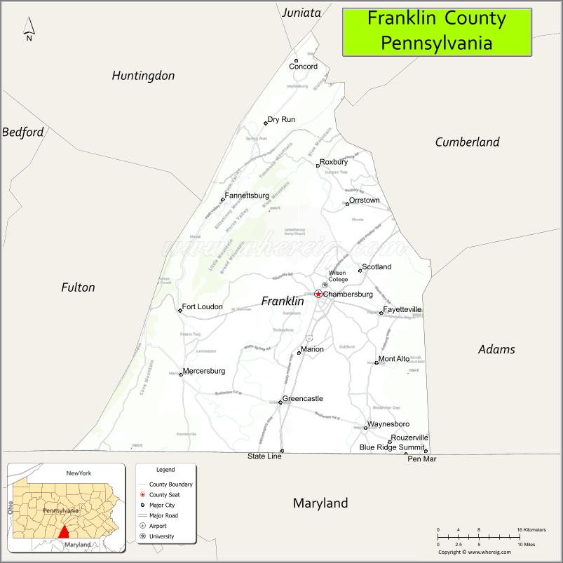
About Franklin County Map, Pennsylvania: The map showing the county boundary, county seat, major cities, highways, water bodies and neighbouring counties.
Pennsylvania Related Links
About Franklin County, Pennsylvania
Franklin County is a county located in the U.S. state of Pennsylvania. It's county seat is Chambersburg. As per 2020 census, the population of Franklin County is 156289 people and population density is square miles. According to the United States Census Bureau, the county has a total area of 771 sq mi (1,997 km2). Franklin County was established on 1784.
Facts about Franklin County, Pennsylvania
| Country | United States |
| State | Pennsylvania |
| Region | South Central Pennsylvania |
| County Seat | Chambersburg |
| Named After | Benjamin Franklin |
| Established | 1784 |
| Organized | 1784 |
| Coordinates | 39.9269° N, 77.7210° W |
| Total Area | 773 sq mi |
| Land Area | 772 sq mi |
| Water Area | 1 sq mi |
| Population (2020 Census) | 155,932 |
| Population Rank | Mid-sized county in Pennsylvania |
| Major City | Chambersburg |
| Main Industries | Manufacturing, Healthcare, Agriculture, Logistics |
| Major Airport | Chambersburg Municipal Airport (N94) |
| Time Zone | Eastern Time (UTC−05:00) |
| Known For | Civil War history, Appalachian Mountains, Agricultural heritage |
| Website | https://www.franklincountypa.gov |
Top Attractions in Franklin County, Pennsylvania
- Caledonia State Park – Forest trails and scenic streams.
- Appalachian Trail (Franklin County) – Popular hiking section.
- Renfrew Museum & Park – Pennsylvania German farmstead.
- Mont Alto State Park – Picnic areas and mountain views.
- Chambersburg Downtown Historic District – Shops and architecture.
- Capitol Theatre Center – Performing arts venue.
- Buchanan’s Birthplace State Park – Presidential birthplace site.
- Wilson College Arboretum – Gardens and walking paths.
- Chambersburg Heritage Center – Local history exhibits.
- Norlo Park – County park and recreation.
- Letterkenny Army Depot (museum area) – Military history displays.
- South Mountain Scenic Byway – Mountain driving route.
Cities & Towns in Franklin County, Pennsylvania
Chambersburg, Waynesboro, Greencastle, Mercersburg, Shippensburg, Fannettsburg, Orrstown, Mont Alto, Roxbury, Fort Loudon, Scotland, Quincy
- Adams County Map
- Allegheny County Map
- Armstrong County Map
- Beaver County Map
- Bedford County Map
- Berks County Map
- Blair County Map
- Bradford County Map
- Bucks County Map
- Butler County Map
- Cambria County Map
- Cameron County Map
- Carbon County Map
- Centre County Map
- Chester County Map
- Clarion County Map
- Clearfield County Map
- Clinton County Map
- Columbia County Map
- Crawford County Map
- Cumberland County Map
- Dauphin County Map
- Delaware County Map
- Elk County Map
- Erie County Map
- Fayette County Map
- Forest County Map
- Franklin County Map
- Fulton County Map
- Greene County Map
- Huntingdon County Map
- Indiana County Map
- Jefferson County Map
- Juniata County Map
- Lackawanna County Map
- Lancaster County Map
- Lawrence County Map
- Lebanon County Map
- Lehigh County Map
- Luzerne County Map
- Lycoming County Map
- McKean County Map
- Mercer County Map
- Mifflin County Map
- Monroe County Map
- Montgomery County Map
- Montour County Map
- Northampton County Map
- Northumberland County Map
- Perry County Map
- Philadelphia County Map
- Pike County Map
- Potter County Map
- Schuylkill County Map
- Snyder County Map
- Somerset County Map
- Sullivan County Map
- Susquehanna County Map
- Tioga County Map
- Union County Map
- Venango County Map
- Warren County Map
- Washington County Map
- Wayne County Map
- Westmoreland County Map
- Wyoming County Map
- York County Map
- Alabama Counties
- Alaska boroughs
- Arizona Counties
- Arkansas Counties
- California County Map
- Colorado Counties
- Connecticut Counties
- Delaware Counties
- Florida County Map
- Georgia County Map
- Hawaii Counties
- Idaho Counties
- Illinois Counties
- Indiana Counties
- Iowa Counties
- Kansas Counties
- Kentucky Counties
- Louisiana Counties
- Maine Counties
- Maryland Counties
- Massachusetts Counties
- Michigan County Map
- Minnesota Counties
- Mississippi Counties
- Missouri Counties
- Montana Counties
- Nebraska Counties
- Nevada Counties
- New York Counties
- New Hampshire Counties
- New Jersey Counties
- New Mexico Counties
- North Carolina Counties
- North Dakota Counties
- Ohio County Map
- Oklahoma Counties
- Oregon Counties
- Pennsylvania Counties
- Rhode Island Counties
- South Carolina Counties
- South Dakota Counties
- Map of Tennessee
- Texas County Map
- Utah Counties
- Vermont Counties
- Virginia Counties
- Washington Counties
- West Virginia Counties
- Wisconsin Counties
- Wyoming Counties