Written and Fact-checked by Whereig Editors | Updated On: May 01, 2026, 13:37 ET
Map of Lackawanna County - Lackawanna County is a county located in the U.S. state of Pennsylvania. Lackawanna County Map showing cities, highways, important places and water bodies. Get Where is Lackawanna County located in the map, major cities in Lackawanna county, population, areas, and places of interest.
Map of Lackawanna County, Pennsylvania
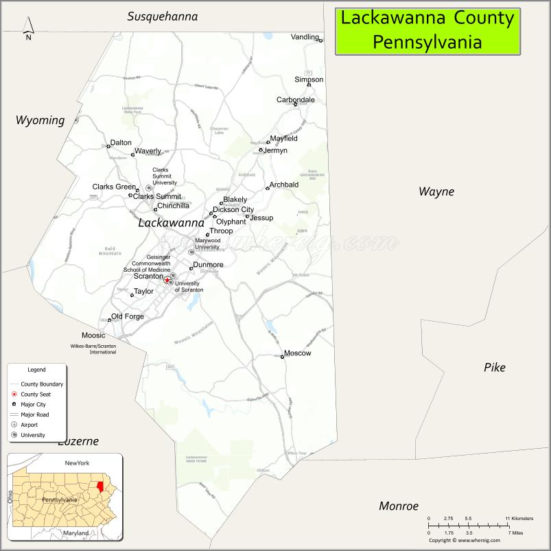
About Lackawanna County Map, Pennsylvania: The map showing the county boundary, county seat, major cities, highways, water bodies and neighbouring counties.
Pennsylvania Related Links
About Lackawanna County, Pennsylvania
Lackawanna County is a county located in the U.S. state of Pennsylvania. It's county seat is Scranton. As per 2020 census, the population of Lackawanna County is 215663 people and population density is square miles. According to the United States Census Bureau, the county has a total area of 465 sq mi (1,204 km2). Lackawanna County was established on 1878.
Facts about Lackawanna County, Pennsylvania
| Country | United States |
| State | Pennsylvania |
| Region | Northeastern Pennsylvania |
| County Seat | Scranton |
| Named After | Lackawanna River |
| Established | 1878 |
| Organized | 1878 |
| Coordinates | 41.4420° N, 75.6096° W |
| Total Area | 465 sq mi |
| Land Area | 458 sq mi |
| Water Area | 7 sq mi |
| Population (2020 Census) | 215,896 |
| Population Rank | Mid-sized county in Pennsylvania |
| Major City | Scranton |
| Main Industries | Healthcare, Education, Manufacturing, Transportation |
| Major Airport | Wilkes-Barre/Scranton International Airport (AVP) |
| Time Zone | Eastern Time (UTC−05:00) |
| Known For | Anthracite coal history, The Electric City, Steamtown |
| Website | https://www.lackawannacounty.org |
Top Attractions in Lackawanna County, Pennsylvania
- Steamtown National Historic Site – Historic steam locomotive park.
- Electric City Trolley Museum – Trolley rides and exhibits.
- Nay Aug Park – Waterfalls, trails, and overlook.
- Scranton Cultural Center – Historic theater and events.
- Lackawanna Coal Mine Tour – Underground mining experience.
- Everhart Museum – Natural history and art.
- Montage Mountain Resorts – Skiing and water park.
- Scranton Iron Furnaces – Industrial heritage site.
- Houdini Museum – Magic and illusion history.
- Anthracite Heritage Museum – Coal region history.
- Downtown Scranton Historic District – Shops and architecture.
- Lake Scranton Walking Trail – Scenic loop trail.
Cities & Towns in Lackawanna County, Pennsylvania
Scranton, Carbondale, Archbald, Clarks Green, Clarks Summit, Dunmore, Moscow, Taylor, Taylor Heights, Throop, Vandling, Waverly, Blakely, Jessup, Mayfield, Olyphant, Roaring Brook, Scott Township
- Adams County Map
- Allegheny County Map
- Armstrong County Map
- Beaver County Map
- Bedford County Map
- Berks County Map
- Blair County Map
- Bradford County Map
- Bucks County Map
- Butler County Map
- Cambria County Map
- Cameron County Map
- Carbon County Map
- Centre County Map
- Chester County Map
- Clarion County Map
- Clearfield County Map
- Clinton County Map
- Columbia County Map
- Crawford County Map
- Cumberland County Map
- Dauphin County Map
- Delaware County Map
- Elk County Map
- Erie County Map
- Fayette County Map
- Forest County Map
- Franklin County Map
- Fulton County Map
- Greene County Map
- Huntingdon County Map
- Indiana County Map
- Jefferson County Map
- Juniata County Map
- Lackawanna County Map
- Lancaster County Map
- Lawrence County Map
- Lebanon County Map
- Lehigh County Map
- Luzerne County Map
- Lycoming County Map
- McKean County Map
- Mercer County Map
- Mifflin County Map
- Monroe County Map
- Montgomery County Map
- Montour County Map
- Northampton County Map
- Northumberland County Map
- Perry County Map
- Philadelphia County Map
- Pike County Map
- Potter County Map
- Schuylkill County Map
- Snyder County Map
- Somerset County Map
- Sullivan County Map
- Susquehanna County Map
- Tioga County Map
- Union County Map
- Venango County Map
- Warren County Map
- Washington County Map
- Wayne County Map
- Westmoreland County Map
- Wyoming County Map
- York County Map
- Alabama Counties
- Alaska boroughs
- Arizona Counties
- Arkansas Counties
- California County Map
- Colorado Counties
- Connecticut Counties
- Delaware Counties
- Florida County Map
- Georgia County Map
- Hawaii Counties
- Idaho Counties
- Illinois Counties
- Indiana Counties
- Iowa Counties
- Kansas Counties
- Kentucky Counties
- Louisiana Counties
- Maine Counties
- Maryland Counties
- Massachusetts Counties
- Michigan County Map
- Minnesota Counties
- Mississippi Counties
- Missouri Counties
- Montana Counties
- Nebraska Counties
- Nevada Counties
- New York Counties
- New Hampshire Counties
- New Jersey Counties
- New Mexico Counties
- North Carolina Counties
- North Dakota Counties
- Ohio County Map
- Oklahoma Counties
- Oregon Counties
- Pennsylvania Counties
- Rhode Island Counties
- South Carolina Counties
- South Dakota Counties
- Map of Tennessee
- Texas County Map
- Utah Counties
- Vermont Counties
- Virginia Counties
- Washington Counties
- West Virginia Counties
- Wisconsin Counties
- Wyoming Counties