Written and Fact-checked by Whereig Editors | Updated On: May 01, 2026, 13:37 ET
Map of Schuylkill County - Schuylkill County is a county located in the U.S. state of Pennsylvania. Schuylkill County Map showing cities, highways, important places and water bodies. Get Where is Schuylkill County located in the map, major cities in Schuylkill county, population, areas, and places of interest.
Map of Schuylkill County, Pennsylvania
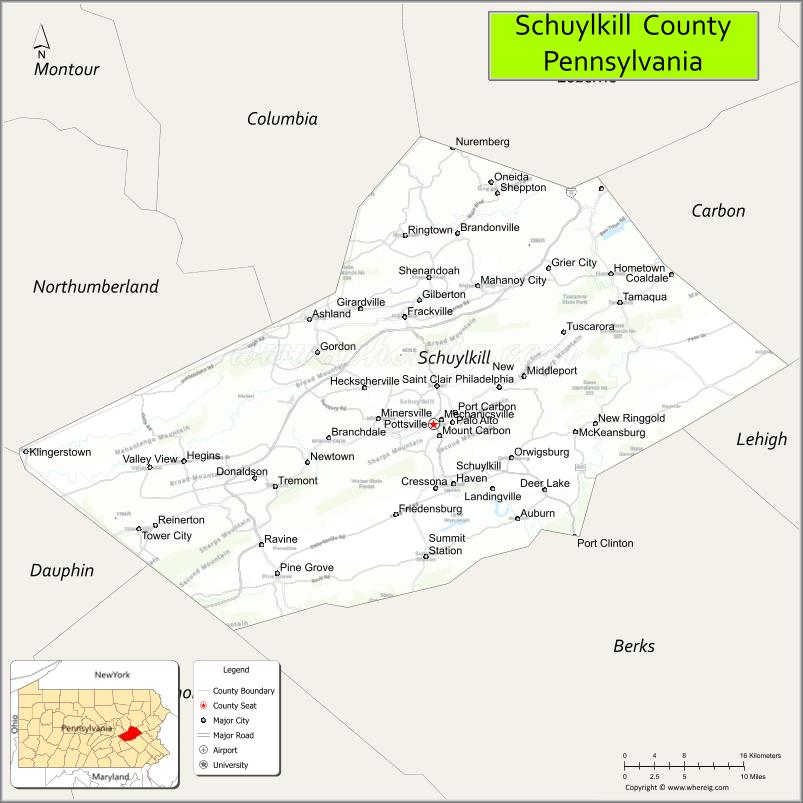
About Schuylkill County Map, Pennsylvania: The map showing the county boundary, county seat, major cities, highways, water bodies and neighbouring counties.
Pennsylvania Related Links
About Schuylkill County, Pennsylvania
Schuylkill County is a county located in the U.S. state of Pennsylvania. It's county seat is Pottsville. As per 2020 census, the population of Schuylkill County is 143264 people and population density is square miles. According to the United States Census Bureau, the county has a total area of 778 sq mi (2,015 km2). Schuylkill County was established on 1811.
Facts about Schuylkill County, Pennsylvania
| Country | United States |
| State | Pennsylvania |
| Region | Northeastern Pennsylvania |
| County Seat | Pottsville |
| Named After | Schuylkill River |
| Established | 1811 |
| Organized | 1811 |
| Coordinates | 40.7024° N, 76.2157° W |
| Total Area | 783 sq mi |
| Land Area | 779 sq mi |
| Water Area | 4 sq mi |
| Population (2020 Census) | 143,049 |
| Population Rank | Mid-sized county in Pennsylvania |
| Major City | Pottsville |
| Main Industries | Manufacturing, Healthcare, Energy, Retail |
| Major Airport | None (nearest regional airports outside county) |
| Time Zone | Eastern Time (UTC−05:00) |
| Known For | Anthracite coal region, Yuengling Brewery, Appalachian Mountains |
| Website | https://www.schuylkillcounty.org |
Top Attractions in Schuylkill County, Pennsylvania
- Yuengling Brewery – America’s oldest brewery tours.
- Reading Blue Mountain & Northern Railroad – Scenic train rides.
- Hawk Mountain Sanctuary (nearby) – Raptor viewing and trails.
- Sweet Arrow Lake County Park – Lake recreation and hiking.
- Locust Lake State Park – Swimming, fishing, and camping.
- Schuylkill County Historical Society – Local history exhibits.
- Pioneer Tunnel Coal Mine – Underground coal mine tours.
- Jerry’s Classic Cars & Collectibles Museum – Vintage vehicles.
- Schuylkill Mall Area – Shopping and dining.
- Hometown Historic District – Small-town architecture.
- Tuscarora State Park – Forest trails and lake views.
- Pottsville Downtown Historic District – Shops and local culture.
Cities & Towns in Schuylkill County, Pennsylvania
Pottsville, Shenandoah, Tamaqua, Mahanoy City, Minersville, Ashland, Frackville, Girardville, Cressona, St. Clair, Pine Grove, Delano, Auburn, Middleport, Orwigsburg, Landingville
- Adams County Map
- Allegheny County Map
- Armstrong County Map
- Beaver County Map
- Bedford County Map
- Berks County Map
- Blair County Map
- Bradford County Map
- Bucks County Map
- Butler County Map
- Cambria County Map
- Cameron County Map
- Carbon County Map
- Centre County Map
- Chester County Map
- Clarion County Map
- Clearfield County Map
- Clinton County Map
- Columbia County Map
- Crawford County Map
- Cumberland County Map
- Dauphin County Map
- Delaware County Map
- Elk County Map
- Erie County Map
- Fayette County Map
- Forest County Map
- Franklin County Map
- Fulton County Map
- Greene County Map
- Huntingdon County Map
- Indiana County Map
- Jefferson County Map
- Juniata County Map
- Lackawanna County Map
- Lancaster County Map
- Lawrence County Map
- Lebanon County Map
- Lehigh County Map
- Luzerne County Map
- Lycoming County Map
- McKean County Map
- Mercer County Map
- Mifflin County Map
- Monroe County Map
- Montgomery County Map
- Montour County Map
- Northampton County Map
- Northumberland County Map
- Perry County Map
- Philadelphia County Map
- Pike County Map
- Potter County Map
- Schuylkill County Map
- Snyder County Map
- Somerset County Map
- Sullivan County Map
- Susquehanna County Map
- Tioga County Map
- Union County Map
- Venango County Map
- Warren County Map
- Washington County Map
- Wayne County Map
- Westmoreland County Map
- Wyoming County Map
- York County Map
- Alabama Counties
- Alaska boroughs
- Arizona Counties
- Arkansas Counties
- California County Map
- Colorado Counties
- Connecticut Counties
- Delaware Counties
- Florida County Map
- Georgia County Map
- Hawaii Counties
- Idaho Counties
- Illinois Counties
- Indiana Counties
- Iowa Counties
- Kansas Counties
- Kentucky Counties
- Louisiana Counties
- Maine Counties
- Maryland Counties
- Massachusetts Counties
- Michigan County Map
- Minnesota Counties
- Mississippi Counties
- Missouri Counties
- Montana Counties
- Nebraska Counties
- Nevada Counties
- New York Counties
- New Hampshire Counties
- New Jersey Counties
- New Mexico Counties
- North Carolina Counties
- North Dakota Counties
- Ohio County Map
- Oklahoma Counties
- Oregon Counties
- Pennsylvania Counties
- Rhode Island Counties
- South Carolina Counties
- South Dakota Counties
- Map of Tennessee
- Texas County Map
- Utah Counties
- Vermont Counties
- Virginia Counties
- Washington Counties
- West Virginia Counties
- Wisconsin Counties
- Wyoming Counties