Written and Fact-checked by Whereig Editors | Updated On: May 01, 2026, 13:37 ET
Map of Cambria County - Cambria County is a county located in the U.S. state of Pennsylvania. Cambria County Map showing cities, highways, important places and water bodies. Get Where is Cambria County located in the map, major cities in Cambria county, population, areas, and places of interest.
Map of Cambria County, Pennsylvania
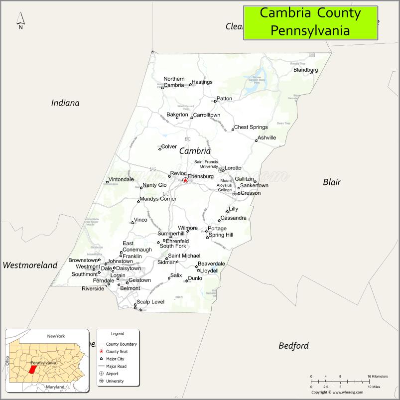
About Cambria County Map, Pennsylvania: The map showing the county boundary, county seat, major cities, highways, water bodies and neighbouring counties.
Pennsylvania Related Links
About Cambria County, Pennsylvania
Cambria County is a county located in the U.S. state of Pennsylvania. It's county seat is Ebensburg. As per 2020 census, the population of Cambria County is 132167 people and population density is square miles. According to the United States Census Bureau, the county has a total area of 693 sq mi (1,795 km2). Cambria County was established on 1804.
Facts about Cambria County, Pennsylvania
| Country | United States |
| State | Pennsylvania |
| Region | Western Pennsylvania |
| County Seat | Ebensburg |
| Named After | Cambria, Latin name for Wales |
| Established | 1804 |
| Organized | 1804 |
| Coordinates | 40.4950° N, 78.7130° W |
| Total Area | 693 sq mi |
| Land Area | 692 sq mi |
| Water Area | 1 sq mi |
| Population (2020 Census) | 133,472 |
| Population Rank | Mid-sized county in Pennsylvania |
| Major City | Johnstown |
| Main Industries | Healthcare, Manufacturing, Education, Energy |
| Major Airport | John Murtha Johnstown–Cambria County Airport (JST) |
| Time Zone | Eastern Time (UTC−05:00) |
| Known For | Johnstown Flood history, Allegheny Mountains, Railroads |
| Website | https://www.cambriacountypa.gov |
Top Attractions in Cambria County, Pennsylvania
- Johnstown Flood Museum – History of the 1889 flood.
- Johnstown Inclined Plane – Historic hillside funicular.
- Horseshoe Curve (nearby) – Famous railroad landmark.
- Allegheny Portage Railroad National Historic Site – Early rail history.
- Prince Gallitzin State Park – Lake recreation and trails.
- Cambria County War Memorial Arena – Sports and events venue.
- Johnstown Discovery Network – Local museums and history.
- Stonycreek River – Paddling and fishing.
- Ebensburg Historic District – County seat and charm.
- Laurel Highlands (nearby) – Scenic mountain region.
- Gallitzin Tunnels Park – Railroad tunnels and views.
- Johnstown Downtown Cultural District – Arts and dining.
Cities & Towns in Cambria County, Pennsylvania
Johnstown, Ebensburg, Cambria Township, Portage, Northern Cambria, Geistown, Richland, Nanty Glo, Patton, Cresson, Carrolltown, Gallitzin, Nicktown, Summerhill, Daisytown, Lower Yoder
- Adams County Map
- Allegheny County Map
- Armstrong County Map
- Beaver County Map
- Bedford County Map
- Berks County Map
- Blair County Map
- Bradford County Map
- Bucks County Map
- Butler County Map
- Cambria County Map
- Cameron County Map
- Carbon County Map
- Centre County Map
- Chester County Map
- Clarion County Map
- Clearfield County Map
- Clinton County Map
- Columbia County Map
- Crawford County Map
- Cumberland County Map
- Dauphin County Map
- Delaware County Map
- Elk County Map
- Erie County Map
- Fayette County Map
- Forest County Map
- Franklin County Map
- Fulton County Map
- Greene County Map
- Huntingdon County Map
- Indiana County Map
- Jefferson County Map
- Juniata County Map
- Lackawanna County Map
- Lancaster County Map
- Lawrence County Map
- Lebanon County Map
- Lehigh County Map
- Luzerne County Map
- Lycoming County Map
- McKean County Map
- Mercer County Map
- Mifflin County Map
- Monroe County Map
- Montgomery County Map
- Montour County Map
- Northampton County Map
- Northumberland County Map
- Perry County Map
- Philadelphia County Map
- Pike County Map
- Potter County Map
- Schuylkill County Map
- Snyder County Map
- Somerset County Map
- Sullivan County Map
- Susquehanna County Map
- Tioga County Map
- Union County Map
- Venango County Map
- Warren County Map
- Washington County Map
- Wayne County Map
- Westmoreland County Map
- Wyoming County Map
- York County Map
- Alabama Counties
- Alaska boroughs
- Arizona Counties
- Arkansas Counties
- California County Map
- Colorado Counties
- Connecticut Counties
- Delaware Counties
- Florida County Map
- Georgia County Map
- Hawaii Counties
- Idaho Counties
- Illinois Counties
- Indiana Counties
- Iowa Counties
- Kansas Counties
- Kentucky Counties
- Louisiana Counties
- Maine Counties
- Maryland Counties
- Massachusetts Counties
- Michigan County Map
- Minnesota Counties
- Mississippi Counties
- Missouri Counties
- Montana Counties
- Nebraska Counties
- Nevada Counties
- New York Counties
- New Hampshire Counties
- New Jersey Counties
- New Mexico Counties
- North Carolina Counties
- North Dakota Counties
- Ohio County Map
- Oklahoma Counties
- Oregon Counties
- Pennsylvania Counties
- Rhode Island Counties
- South Carolina Counties
- South Dakota Counties
- Map of Tennessee
- Texas County Map
- Utah Counties
- Vermont Counties
- Virginia Counties
- Washington Counties
- West Virginia Counties
- Wisconsin Counties
- Wyoming Counties