Written and Fact-checked by Whereig Editors | Updated On: May 01, 2026, 13:37 ET
Map of Clearfield County - Clearfield County is a county located in the U.S. state of Pennsylvania. Clearfield County Map showing cities, highways, important places and water bodies. Get Where is Clearfield County located in the map, major cities in Clearfield county, population, areas, and places of interest.
Map of Clearfield County, Pennsylvania
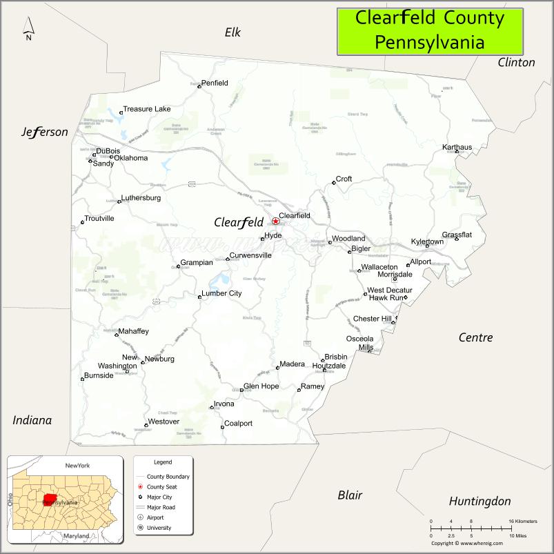
About Clearfield County Map, Pennsylvania: The map showing the county boundary, county seat, major cities, highways, water bodies and neighbouring counties.
Pennsylvania Related Links
About Clearfield County, Pennsylvania
Clearfield County is a county located in the U.S. state of Pennsylvania. It's county seat is Clearfield. As per 2020 census, the population of Clearfield County is 80082 people and population density is square miles. According to the United States Census Bureau, the county has a total area of 1,154 sq mi (2,989 km2). Clearfield County was established on 1804.
Facts about Clearfield County, Pennsylvania
| Country | United States |
| State | Pennsylvania |
| Region | Central Pennsylvania |
| County Seat | Clearfield |
| Named After | Clearfield Creek |
| Established | 1804 |
| Organized | 1804 |
| Coordinates | 41.0006° N, 78.4747° W |
| Total Area | 1,154 sq mi |
| Land Area | 1,149 sq mi |
| Water Area | 5 sq mi |
| Population (2020 Census) | 80,562 |
| Population Rank | Mid-sized county in Pennsylvania |
| Major City | DuBois |
| Main Industries | Manufacturing, Energy, Healthcare, Forestry |
| Major Airport | DuBois Regional Airport (DUJ) |
| Time Zone | Eastern Time (UTC−05:00) |
| Known For | Coal history, State forests, Outdoor recreation |
| Website | https://www.clearfieldco.org |
Top Attractions in Clearfield County, Pennsylvania
- Clearfield County Historical Society – Local history exhibits.
- Curwensville Lake – Boating and lakeside recreation.
- Bilger’s Rocks – Massive sandstone rock formations.
- Parker Dam State Park – Hiking, camping, and swimming.
- Elk Country Visitor Center (nearby) – Elk viewing and exhibits.
- Houtzdale Coal Mining Museum – Coal mining history.
- Clearfield Riverwalk – Scenic riverfront path.
- Rockton Mountain Bike Trail – Biking and outdoor recreation.
- Moshannon State Forest – Forest trails and wildlife.
- Curwensville Historic District – Small-town charm.
- Anderson Creek Gorge – Natural rock gorge.
- Penn’s Cave (nearby) – Cave tours and wildlife park.
Cities & Towns in Clearfield County, Pennsylvania
Clearfield, DuBois, Curwensville, Philipsburg, Mahaffey, Westover, Grampian, Karthaus, Glen Hope, Wallaceton, Houtzdale, Sandy Township, Bell Township, Bloom Township
- Adams County Map
- Allegheny County Map
- Armstrong County Map
- Beaver County Map
- Bedford County Map
- Berks County Map
- Blair County Map
- Bradford County Map
- Bucks County Map
- Butler County Map
- Cambria County Map
- Cameron County Map
- Carbon County Map
- Centre County Map
- Chester County Map
- Clarion County Map
- Clearfield County Map
- Clinton County Map
- Columbia County Map
- Crawford County Map
- Cumberland County Map
- Dauphin County Map
- Delaware County Map
- Elk County Map
- Erie County Map
- Fayette County Map
- Forest County Map
- Franklin County Map
- Fulton County Map
- Greene County Map
- Huntingdon County Map
- Indiana County Map
- Jefferson County Map
- Juniata County Map
- Lackawanna County Map
- Lancaster County Map
- Lawrence County Map
- Lebanon County Map
- Lehigh County Map
- Luzerne County Map
- Lycoming County Map
- McKean County Map
- Mercer County Map
- Mifflin County Map
- Monroe County Map
- Montgomery County Map
- Montour County Map
- Northampton County Map
- Northumberland County Map
- Perry County Map
- Philadelphia County Map
- Pike County Map
- Potter County Map
- Schuylkill County Map
- Snyder County Map
- Somerset County Map
- Sullivan County Map
- Susquehanna County Map
- Tioga County Map
- Union County Map
- Venango County Map
- Warren County Map
- Washington County Map
- Wayne County Map
- Westmoreland County Map
- Wyoming County Map
- York County Map
- Alabama Counties
- Alaska boroughs
- Arizona Counties
- Arkansas Counties
- California County Map
- Colorado Counties
- Connecticut Counties
- Delaware Counties
- Florida County Map
- Georgia County Map
- Hawaii Counties
- Idaho Counties
- Illinois Counties
- Indiana Counties
- Iowa Counties
- Kansas Counties
- Kentucky Counties
- Louisiana Counties
- Maine Counties
- Maryland Counties
- Massachusetts Counties
- Michigan County Map
- Minnesota Counties
- Mississippi Counties
- Missouri Counties
- Montana Counties
- Nebraska Counties
- Nevada Counties
- New York Counties
- New Hampshire Counties
- New Jersey Counties
- New Mexico Counties
- North Carolina Counties
- North Dakota Counties
- Ohio County Map
- Oklahoma Counties
- Oregon Counties
- Pennsylvania Counties
- Rhode Island Counties
- South Carolina Counties
- South Dakota Counties
- Map of Tennessee
- Texas County Map
- Utah Counties
- Vermont Counties
- Virginia Counties
- Washington Counties
- West Virginia Counties
- Wisconsin Counties
- Wyoming Counties