Written and Fact-checked by Whereig Editors | Updated On: May 01, 2026, 13:37 ET
Map of Pike County - Pike County is a county located in the U.S. state of Pennsylvania. Pike County Map showing cities, highways, important places and water bodies. Get Where is Pike County located in the map, major cities in Pike county, population, areas, and places of interest.
Map of Pike County, Pennsylvania
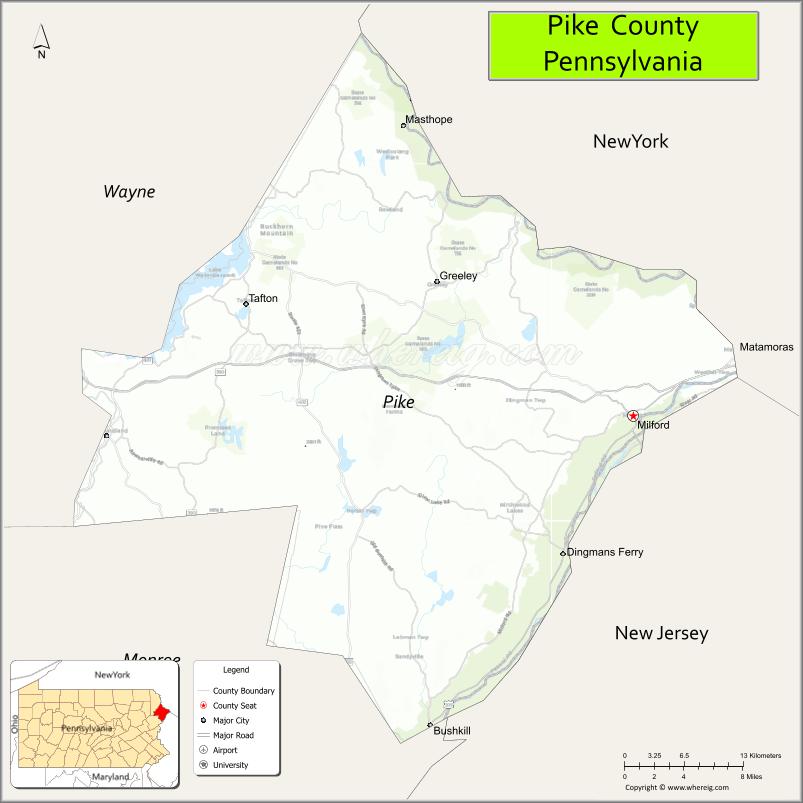
About Pike County Map, Pennsylvania: The map showing the county boundary, county seat, major cities, highways, water bodies and neighbouring counties.
Pennsylvania Related Links
About Pike County, Pennsylvania
Pike County is a county located in the U.S. state of Pennsylvania. It's county seat is Milford. As per 2020 census, the population of Pike County is 59952 people and population density is square miles. According to the United States Census Bureau, the county has a total area of 567 sq mi (1,469 km2). Pike County was established on 1814.
Facts about Pike County, Pennsylvania
| Country | United States |
| State | Pennsylvania |
| Region | Northeastern Pennsylvania |
| County Seat | Milford |
| Named After | Zebulon Pike |
| Established | 1814 |
| Organized | 1814 |
| Coordinates | 41.3315° N, 75.0310° W |
| Total Area | 567 sq mi |
| Land Area | 545 sq mi |
| Water Area | 22 sq mi |
| Population (2020 Census) | 58,535 |
| Population Rank | Smaller county in Pennsylvania |
| Major City | Milford |
| Main Industries | Tourism, Healthcare, Retail, Construction |
| Major Airport | None (nearest regional airports outside county) |
| Time Zone | Eastern Time (UTC−05:00) |
| Known For | Delaware Water Gap, Outdoor recreation, Scenic landscapes |
| Website | https://www.pikepa.org |
Top Attractions in Pike County, Pennsylvania
- Delaware Water Gap National Recreation Area – Hiking, waterfalls, and river views.
- Bushkill Falls – Series of scenic waterfalls.
- Delaware River – Boating, fishing, and rafting.
- Grey Towers National Historic Site – Gifford Pinchot’s historic home.
- Upper Delaware Scenic Byway – Riverfront driving route.
- Milford Historic District – Shops, dining, and architecture.
- Raymondskill Falls – Tallest waterfall in Pennsylvania.
- Promised Land State Park – Lakes, camping, and trails.
- Lacawac Sanctuary – Nature preserve and education center.
- High Point Scenic Vista (nearby) – Tri-state overlook.
- Shohola Falls – Scenic roadside waterfall.
- Upper Delaware River Towns – River villages and scenery.
Cities & Towns in Pike County, Pennsylvania
Milford, Matamoras, Dingmans Ferry, Bushkill, Shohola, Blooming Grove, Westfall, Lehman, Lackawaxen, Palmyra
- Adams County Map
- Allegheny County Map
- Armstrong County Map
- Beaver County Map
- Bedford County Map
- Berks County Map
- Blair County Map
- Bradford County Map
- Bucks County Map
- Butler County Map
- Cambria County Map
- Cameron County Map
- Carbon County Map
- Centre County Map
- Chester County Map
- Clarion County Map
- Clearfield County Map
- Clinton County Map
- Columbia County Map
- Crawford County Map
- Cumberland County Map
- Dauphin County Map
- Delaware County Map
- Elk County Map
- Erie County Map
- Fayette County Map
- Forest County Map
- Franklin County Map
- Fulton County Map
- Greene County Map
- Huntingdon County Map
- Indiana County Map
- Jefferson County Map
- Juniata County Map
- Lackawanna County Map
- Lancaster County Map
- Lawrence County Map
- Lebanon County Map
- Lehigh County Map
- Luzerne County Map
- Lycoming County Map
- McKean County Map
- Mercer County Map
- Mifflin County Map
- Monroe County Map
- Montgomery County Map
- Montour County Map
- Northampton County Map
- Northumberland County Map
- Perry County Map
- Philadelphia County Map
- Pike County Map
- Potter County Map
- Schuylkill County Map
- Snyder County Map
- Somerset County Map
- Sullivan County Map
- Susquehanna County Map
- Tioga County Map
- Union County Map
- Venango County Map
- Warren County Map
- Washington County Map
- Wayne County Map
- Westmoreland County Map
- Wyoming County Map
- York County Map
- Alabama Counties
- Alaska boroughs
- Arizona Counties
- Arkansas Counties
- California County Map
- Colorado Counties
- Connecticut Counties
- Delaware Counties
- Florida County Map
- Georgia County Map
- Hawaii Counties
- Idaho Counties
- Illinois Counties
- Indiana Counties
- Iowa Counties
- Kansas Counties
- Kentucky Counties
- Louisiana Counties
- Maine Counties
- Maryland Counties
- Massachusetts Counties
- Michigan County Map
- Minnesota Counties
- Mississippi Counties
- Missouri Counties
- Montana Counties
- Nebraska Counties
- Nevada Counties
- New York Counties
- New Hampshire Counties
- New Jersey Counties
- New Mexico Counties
- North Carolina Counties
- North Dakota Counties
- Ohio County Map
- Oklahoma Counties
- Oregon Counties
- Pennsylvania Counties
- Rhode Island Counties
- South Carolina Counties
- South Dakota Counties
- Map of Tennessee
- Texas County Map
- Utah Counties
- Vermont Counties
- Virginia Counties
- Washington Counties
- West Virginia Counties
- Wisconsin Counties
- Wyoming Counties