Written and Fact-checked by Whereig Web Team | Updated On: November 01, 2025, 14:37 ET
Map of Columbia County - Columbia County is a county located in the U.S. state of Pennsylvania. Columbia County Map showing cities, highways, important places and water bodies. Get Where is Columbia County located in the map, major cities in Columbia county, population, areas, and places of interest.
Map of Columbia County, Pennsylvania
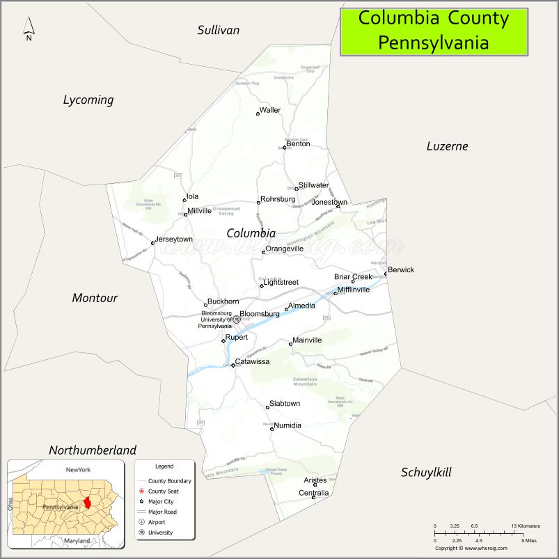
About Columbia County Map, Pennsylvania: The map showing the county boundary, county seat, major cities, highways, water bodies and neighbouring counties.
Pennsylvania More Maps & Info
About Columbia County, Pennsylvania
Columbia County is a county located in the U.S. state of Pennsylvania. It's county seat is Bloomsburg. As per 2020 census, the population of Columbia County is 64872 people and population density is square miles. According to the United States Census Bureau, the county has a total area of 490 sq mi (1,269 km2). Columbia County was established on 1813.
Facts about Columbia County, Pennsylvania
| Country | United States |
| State | Pennsylvania |
| Region | Northeastern Pennsylvania |
| County Seat | Bloomsburg |
| Named After | Christopher Columbus |
| Established | 1813 |
| Organized | 1813 |
| Coordinates | 41.0460° N, 76.4050° W |
| Total Area | ~387 sq mi |
| Land Area | ~383 sq mi |
| Water Area | ~4 sq mi |
| Population (2020) | 64,727 |
| Population Rank | Smaller county in Pennsylvania |
| Major City | Bloomsburg |
| Main Industries | Education, Healthcare, Manufacturing, Agriculture |
| Major Airport | None (nearest regional airports outside county) |
| Time Zone | Eastern Time (UTC−05:00) |
| Known For | Bloomsburg University, Susquehanna River, County fairs |
| Website | https://www.columbiapa.org |
Top Attractions in Columbia County, Pennsylvania
- Knoebels Amusement Resort – Free-admission amusement park.
- Bloomsburg Fairgrounds – Site of the Bloomsburg Fair.
- Bloomsburg University Campus – Historic college setting.
- Columbia County Historical Society – Local history exhibits.
- Susquehanna River – Fishing and river scenery.
- Berwick Riverfront Park – Walking paths and river views.
- Montour Preserve – Trails and wildlife viewing.
- Red Rock Mountain Overlook – Scenic valley views.
- Fishing Creek Valley – Rural scenery and streams.
- Espenshade Covered Bridge – Historic wooden bridge.
- Bloomsburg Historic District – Shops and architecture.
- Central Susquehanna Valley Rail Trail – Walking and biking trail.
Cities & Towns in Columbia County, Pennsylvania
Bloomsburg, Danville, Berwick, Catawissa, Millville, Orangeville, Elysburg, Lightstreet, Stillwater, Jerseytown, Espy, Lime Ridge
- Adams County Map
- Allegheny County Map
- Armstrong County Map
- Beaver County Map
- Bedford County Map
- Berks County Map
- Blair County Map
- Bradford County Map
- Bucks County Map
- Butler County Map
- Cambria County Map
- Cameron County Map
- Carbon County Map
- Centre County Map
- Chester County Map
- Clarion County Map
- Clearfield County Map
- Clinton County Map
- Columbia County Map
- Crawford County Map
- Cumberland County Map
- Dauphin County Map
- Delaware County Map
- Elk County Map
- Erie County Map
- Fayette County Map
- Forest County Map
- Franklin County Map
- Fulton County Map
- Greene County Map
- Huntingdon County Map
- Indiana County Map
- Jefferson County Map
- Juniata County Map
- Lackawanna County Map
- Lancaster County Map
- Lawrence County Map
- Lebanon County Map
- Lehigh County Map
- Luzerne County Map
- Lycoming County Map
- McKean County Map
- Mercer County Map
- Mifflin County Map
- Monroe County Map
- Montgomery County Map
- Montour County Map
- Northampton County Map
- Northumberland County Map
- Perry County Map
- Philadelphia County Map
- Pike County Map
- Potter County Map
- Schuylkill County Map
- Snyder County Map
- Somerset County Map
- Sullivan County Map
- Susquehanna County Map
- Tioga County Map
- Union County Map
- Venango County Map
- Warren County Map
- Washington County Map
- Wayne County Map
- Westmoreland County Map
- Wyoming County Map
- York County Map
- Alabama Counties
- Alaska boroughs
- Arizona Counties
- Arkansas Counties
- California County Map
- Colorado Counties
- Connecticut Counties
- Delaware Counties
- Florida County Map
- Georgia County Map
- Hawaii Counties
- Idaho Counties
- Illinois Counties
- Indiana Counties
- Iowa Counties
- Kansas Counties
- Kentucky Counties
- Louisiana Counties
- Maine Counties
- Maryland Counties
- Massachusetts Counties
- Michigan County Map
- Minnesota Counties
- Mississippi Counties
- Missouri Counties
- Montana Counties
- Nebraska Counties
- New Hampshire Counties
- New Jersey Counties
- New Mexico Counties
- North Carolina Counties
- North Dakota Counties
- Oklahoma Counties
- Oregon Counties
- Pennsylvania Counties
- Rhode Island Counties
- South Carolina Counties
- South Dakota Counties
- Map of Tennessee
- Texas County Map
- Utah Counties
- Vermont Counties
- Virginia Counties
- Washington Counties
- West Virginia Counties
- Wisconsin Counties
- Wyoming Counties
- Nevada Counties
- New York Counties
- Ohio County Map