Written and Fact-checked by Whereig Editors | Updated On: May 01, 2026, 13:37 ET
Map of Greene County - Greene County is a county located in the U.S. state of Pennsylvania. Greene County Map showing cities, highways, important places and water bodies. Get Where is Greene County located in the map, major cities in Greene county, population, areas, and places of interest.
Map of Greene County, Pennsylvania
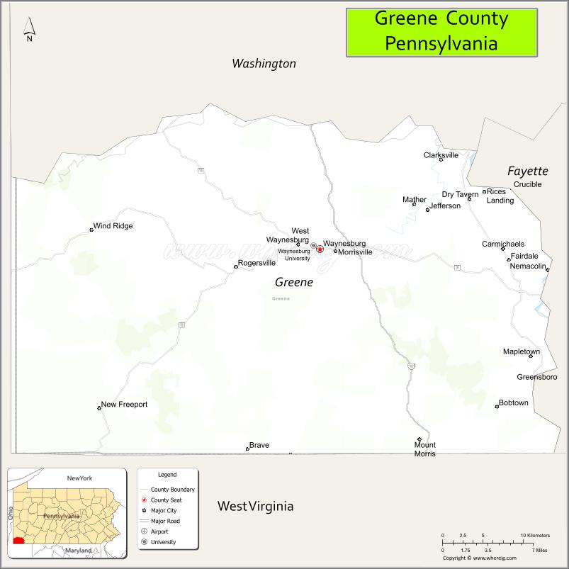
About Greene County Map, Pennsylvania: The map showing the county boundary, county seat, major cities, highways, water bodies and neighbouring counties.
Pennsylvania Related Links
About Greene County, Pennsylvania
Greene County is a county located in the U.S. state of Pennsylvania. It's county seat is Waynesburg. As per 2020 census, the population of Greene County is 35369 people and population density is square miles. According to the United States Census Bureau, the county has a total area of 578 sq mi (1,497 km2). Greene County was established on 1796.
Facts about Greene County, Pennsylvania
| Country | United States |
| State | Pennsylvania |
| Region | Southwestern Pennsylvania |
| County Seat | Waynesburg |
| Named After | Nathanael Greene |
| Established | 1796 |
| Organized | 1796 |
| Coordinates | 39.8478° N, 80.2131° W |
| Total Area | 578 sq mi |
| Land Area | 576 sq mi |
| Water Area | 2 sq mi |
| Population (2020 Census) | 35,798 |
| Population Rank | Smaller county in Pennsylvania |
| Major City | Waynesburg |
| Main Industries | Energy, Agriculture, Education, Healthcare |
| Major Airport | Greene County Airport (WAY) |
| Time Zone | Eastern Time (UTC−05:00) |
| Known For | Coal and natural gas production, Rural communities, Appalachian foothills |
| Website | https://www.greenecountypa.gov |
Top Attractions in Greene County, Pennsylvania
- Ryerson Station State Park – Lake, trails, and recreation.
- Greene County Historical Society Museum – Local history exhibits.
- Waynesburg Downtown Historic District – Shops and small-town charm.
- Monongahela River – Fishing and river views.
- Enlow Fork Mine Overlook – Industrial and scenic views.
- Rohanna’s Golf Course – Scenic golfing destination.
- Greene County Fairgrounds – Annual fair and events.
- Ten Mile Creek – Paddling and fishing stream.
- Greene River Trail – Walking and biking path.
- Raccoon Creek (nearby) – Nature and recreation.
- Fort Jackson Historic Site – Early frontier history.
- Evergreen Drive-In Theatre (nearby) – Classic drive-in movies.
Cities & Towns in Greene County, Pennsylvania
Waynesburg, Jefferson, Carmichaels, Masontown, Rices Landing, Rogersville, Bobtown, Dry Tavern, Mount Morris, Perryopolis
- Adams County Map
- Allegheny County Map
- Armstrong County Map
- Beaver County Map
- Bedford County Map
- Berks County Map
- Blair County Map
- Bradford County Map
- Bucks County Map
- Butler County Map
- Cambria County Map
- Cameron County Map
- Carbon County Map
- Centre County Map
- Chester County Map
- Clarion County Map
- Clearfield County Map
- Clinton County Map
- Columbia County Map
- Crawford County Map
- Cumberland County Map
- Dauphin County Map
- Delaware County Map
- Elk County Map
- Erie County Map
- Fayette County Map
- Forest County Map
- Franklin County Map
- Fulton County Map
- Greene County Map
- Huntingdon County Map
- Indiana County Map
- Jefferson County Map
- Juniata County Map
- Lackawanna County Map
- Lancaster County Map
- Lawrence County Map
- Lebanon County Map
- Lehigh County Map
- Luzerne County Map
- Lycoming County Map
- McKean County Map
- Mercer County Map
- Mifflin County Map
- Monroe County Map
- Montgomery County Map
- Montour County Map
- Northampton County Map
- Northumberland County Map
- Perry County Map
- Philadelphia County Map
- Pike County Map
- Potter County Map
- Schuylkill County Map
- Snyder County Map
- Somerset County Map
- Sullivan County Map
- Susquehanna County Map
- Tioga County Map
- Union County Map
- Venango County Map
- Warren County Map
- Washington County Map
- Wayne County Map
- Westmoreland County Map
- Wyoming County Map
- York County Map
- Alabama Counties
- Alaska boroughs
- Arizona Counties
- Arkansas Counties
- California County Map
- Colorado Counties
- Connecticut Counties
- Delaware Counties
- Florida County Map
- Georgia County Map
- Hawaii Counties
- Idaho Counties
- Illinois Counties
- Indiana Counties
- Iowa Counties
- Kansas Counties
- Kentucky Counties
- Louisiana Counties
- Maine Counties
- Maryland Counties
- Massachusetts Counties
- Michigan County Map
- Minnesota Counties
- Mississippi Counties
- Missouri Counties
- Montana Counties
- Nebraska Counties
- Nevada Counties
- New York Counties
- New Hampshire Counties
- New Jersey Counties
- New Mexico Counties
- North Carolina Counties
- North Dakota Counties
- Ohio County Map
- Oklahoma Counties
- Oregon Counties
- Pennsylvania Counties
- Rhode Island Counties
- South Carolina Counties
- South Dakota Counties
- Map of Tennessee
- Texas County Map
- Utah Counties
- Vermont Counties
- Virginia Counties
- Washington Counties
- West Virginia Counties
- Wisconsin Counties
- Wyoming Counties