Written and Fact-checked by Whereig Editors | Updated On: May 01, 2026, 13:37 ET
Map of Chester County - Chester County is a county located in the U.S. state of Pennsylvania. Chester County Map showing cities, highways, important places and water bodies. Get Where is Chester County located in the map, major cities in Chester county, population, areas, and places of interest.
Map of Chester County, Pennsylvania
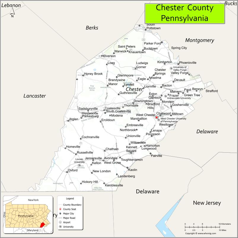
About Chester County Map, Pennsylvania: The map showing the county boundary, county seat, major cities, highways, water bodies and neighbouring counties.
Pennsylvania Related Links
About Chester County, Pennsylvania
Chester County is a county located in the U.S. state of Pennsylvania. It's county seat is West Chester. As per 2020 census, the population of Chester County is 538649 people and population density is square miles. According to the United States Census Bureau, the county has a total area of 760 sq mi (1,968 km2). Chester County was established on 1682.
Facts about Chester County, Pennsylvania
| Country | United States |
| State | Pennsylvania |
| Region | Southeastern Pennsylvania |
| County Seat | West Chester |
| Named After | Chester, England |
| Established | 1682 |
| Organized | 1682 |
| Coordinates | 39.9748° N, 75.7560° W |
| Total Area | 759 sq mi |
| Land Area | 751 sq mi |
| Water Area | 8 sq mi |
| Population (2020 Census) | 534,413 |
| Population Rank | Third most populous county in Pennsylvania |
| Major City | West Chester |
| Main Industries | Healthcare, Biotechnology, Education, Finance |
| Major Airport | Chester County G. O. Carlson Airport (CTH) |
| Time Zone | Eastern Time (UTC−05:00) |
| Known For | Brandywine Valley, Historic towns, Revolutionary War sites |
| Website | https://www.chesco.org |
Top Attractions in Chester County, Pennsylvania
- Longwood Gardens – World-famous botanical gardens.
- Valley Forge National Historical Park – Revolutionary War history.
- Brandywine River Museum of Art – American art and Wyeth works.
- Strasburg Rail Road (nearby) – Historic steam train rides.
- Marsh Creek State Park – Lake recreation and trails.
- Hopewell Furnace National Historic Site – Iron plantation history.
- Chanticleer Garden – Decorative pleasure garden.
- West Chester Downtown Historic District – Shops and dining.
- Ridley Creek State Park – Trails and open spaces.
- American Helicopter Museum – Aviation exhibits.
- Brandywine Battlefield Park – Revolutionary War site.
- Exton Square Mall – Shopping and entertainment.
Cities & Towns in Chester County, Pennsylvania
West Chester, Phoenixville, Kennett Square, Malvern, Downingtown, Coatesville, Exton, Paoli, Thorndale, Atglen, Oxford, Honey Brook, West Grove, Spring City, Lionville, Avondale
- Adams County Map
- Allegheny County Map
- Armstrong County Map
- Beaver County Map
- Bedford County Map
- Berks County Map
- Blair County Map
- Bradford County Map
- Bucks County Map
- Butler County Map
- Cambria County Map
- Cameron County Map
- Carbon County Map
- Centre County Map
- Chester County Map
- Clarion County Map
- Clearfield County Map
- Clinton County Map
- Columbia County Map
- Crawford County Map
- Cumberland County Map
- Dauphin County Map
- Delaware County Map
- Elk County Map
- Erie County Map
- Fayette County Map
- Forest County Map
- Franklin County Map
- Fulton County Map
- Greene County Map
- Huntingdon County Map
- Indiana County Map
- Jefferson County Map
- Juniata County Map
- Lackawanna County Map
- Lancaster County Map
- Lawrence County Map
- Lebanon County Map
- Lehigh County Map
- Luzerne County Map
- Lycoming County Map
- McKean County Map
- Mercer County Map
- Mifflin County Map
- Monroe County Map
- Montgomery County Map
- Montour County Map
- Northampton County Map
- Northumberland County Map
- Perry County Map
- Philadelphia County Map
- Pike County Map
- Potter County Map
- Schuylkill County Map
- Snyder County Map
- Somerset County Map
- Sullivan County Map
- Susquehanna County Map
- Tioga County Map
- Union County Map
- Venango County Map
- Warren County Map
- Washington County Map
- Wayne County Map
- Westmoreland County Map
- Wyoming County Map
- York County Map
- Alabama Counties
- Alaska boroughs
- Arizona Counties
- Arkansas Counties
- California County Map
- Colorado Counties
- Connecticut Counties
- Delaware Counties
- Florida County Map
- Georgia County Map
- Hawaii Counties
- Idaho Counties
- Illinois Counties
- Indiana Counties
- Iowa Counties
- Kansas Counties
- Kentucky Counties
- Louisiana Counties
- Maine Counties
- Maryland Counties
- Massachusetts Counties
- Michigan County Map
- Minnesota Counties
- Mississippi Counties
- Missouri Counties
- Montana Counties
- Nebraska Counties
- Nevada Counties
- New York Counties
- New Hampshire Counties
- New Jersey Counties
- New Mexico Counties
- North Carolina Counties
- North Dakota Counties
- Ohio County Map
- Oklahoma Counties
- Oregon Counties
- Pennsylvania Counties
- Rhode Island Counties
- South Carolina Counties
- South Dakota Counties
- Map of Tennessee
- Texas County Map
- Utah Counties
- Vermont Counties
- Virginia Counties
- Washington Counties
- West Virginia Counties
- Wisconsin Counties
- Wyoming Counties