Written and Fact-checked by Whereig Editors | Updated On: May 01, 2026, 13:37 ET
Map of Cameron County - Cameron County is a county located in the U.S. state of Pennsylvania. Cameron County Map showing cities, highways, important places and water bodies. Get Where is Cameron County located in the map, major cities in Cameron county, population, areas, and places of interest.
Map of Cameron County, Pennsylvania
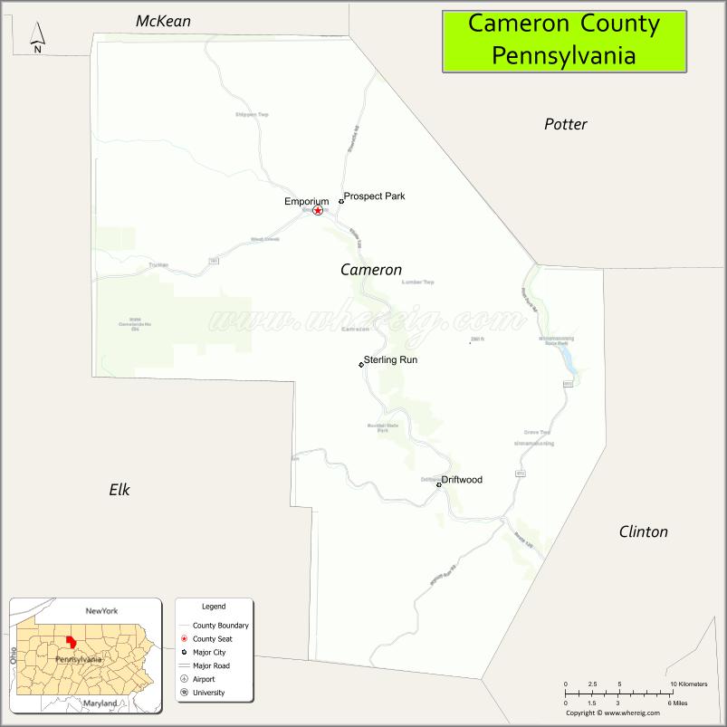
About Cameron County Map, Pennsylvania: The map showing the county boundary, county seat, major cities, highways, water bodies and neighbouring counties.
Pennsylvania Related Links
About Cameron County, Pennsylvania
Cameron County is a county located in the U.S. state of Pennsylvania. It's county seat is Emporium. As per 2020 census, the population of Cameron County is 4459 people and population density is square miles. According to the United States Census Bureau, the county has a total area of 399 sq mi (1,033 km2). Cameron County was established on 1860.
Facts about Cameron County, Pennsylvania
| Country | United States |
| State | Pennsylvania |
| Region | North Central Pennsylvania |
| County Seat | Emporium |
| Named After | Simon Cameron |
| Established | 1860 |
| Organized | 1860 |
| Coordinates | 41.4362° N, 78.2031° W |
| Total Area | 398 sq mi |
| Land Area | 396 sq mi |
| Water Area | 2 sq mi |
| Population (2020 Census) | 4,547 |
| Population Rank | Least populous county in Pennsylvania |
| Major City | Emporium |
| Main Industries | Forestry, Manufacturing, Tourism |
| Major Airport | None (nearest regional airports outside county) |
| Time Zone | Eastern Time (UTC−05:00) |
| Known For | Elk State Forest, Dark skies, Rural wilderness |
| Website | https://www.cameroncountypa.gov |
Top Attractions in Cameron County, Pennsylvania
- Elk State Forest – Elk viewing and forest trails.
- Elk Country Visitor Center – Elk exhibits and viewing area.
- Sizerville State Park – Camping, swimming, and hiking.
- Sinnemahoning State Park – Wildlife watching and boating.
- Sinnemahoning Creek – Fishing and paddling waterway.
- Benezette Area – Prime elk habitat and scenery.
- Little Toby Creek – Trout fishing stream.
- Quehanna Wild Area (nearby) – Remote wilderness trails.
- Cameron County Historical Society – Local history exhibits.
- Jerry Run Scenic Area – Forest views and picnic spots.
- Emporium Downtown Area – Small-town shops and dining.
- Logan Falls (seasonal) – Scenic woodland waterfall.
Cities & Towns in Cameron County, Pennsylvania
Emporium, Driftwood, Sinnemahoning, Grove Township, Shippen Township, Portage Township
- Adams County Map
- Allegheny County Map
- Armstrong County Map
- Beaver County Map
- Bedford County Map
- Berks County Map
- Blair County Map
- Bradford County Map
- Bucks County Map
- Butler County Map
- Cambria County Map
- Cameron County Map
- Carbon County Map
- Centre County Map
- Chester County Map
- Clarion County Map
- Clearfield County Map
- Clinton County Map
- Columbia County Map
- Crawford County Map
- Cumberland County Map
- Dauphin County Map
- Delaware County Map
- Elk County Map
- Erie County Map
- Fayette County Map
- Forest County Map
- Franklin County Map
- Fulton County Map
- Greene County Map
- Huntingdon County Map
- Indiana County Map
- Jefferson County Map
- Juniata County Map
- Lackawanna County Map
- Lancaster County Map
- Lawrence County Map
- Lebanon County Map
- Lehigh County Map
- Luzerne County Map
- Lycoming County Map
- McKean County Map
- Mercer County Map
- Mifflin County Map
- Monroe County Map
- Montgomery County Map
- Montour County Map
- Northampton County Map
- Northumberland County Map
- Perry County Map
- Philadelphia County Map
- Pike County Map
- Potter County Map
- Schuylkill County Map
- Snyder County Map
- Somerset County Map
- Sullivan County Map
- Susquehanna County Map
- Tioga County Map
- Union County Map
- Venango County Map
- Warren County Map
- Washington County Map
- Wayne County Map
- Westmoreland County Map
- Wyoming County Map
- York County Map
- Alabama Counties
- Alaska boroughs
- Arizona Counties
- Arkansas Counties
- California County Map
- Colorado Counties
- Connecticut Counties
- Delaware Counties
- Florida County Map
- Georgia County Map
- Hawaii Counties
- Idaho Counties
- Illinois Counties
- Indiana Counties
- Iowa Counties
- Kansas Counties
- Kentucky Counties
- Louisiana Counties
- Maine Counties
- Maryland Counties
- Massachusetts Counties
- Michigan County Map
- Minnesota Counties
- Mississippi Counties
- Missouri Counties
- Montana Counties
- Nebraska Counties
- Nevada Counties
- New York Counties
- New Hampshire Counties
- New Jersey Counties
- New Mexico Counties
- North Carolina Counties
- North Dakota Counties
- Ohio County Map
- Oklahoma Counties
- Oregon Counties
- Pennsylvania Counties
- Rhode Island Counties
- South Carolina Counties
- South Dakota Counties
- Map of Tennessee
- Texas County Map
- Utah Counties
- Vermont Counties
- Virginia Counties
- Washington Counties
- West Virginia Counties
- Wisconsin Counties
- Wyoming Counties