Written and Fact-checked by Whereig Editors | Updated On: May 01, 2026, 13:37 ET
Map of Bedford County - Bedford County is a county located in the U.S. state of Pennsylvania. Bedford County Map showing cities, highways, important places and water bodies. Get Where is Bedford County located in the map, major cities in Bedford county, population, areas, and places of interest.
Map of Bedford County, Pennsylvania
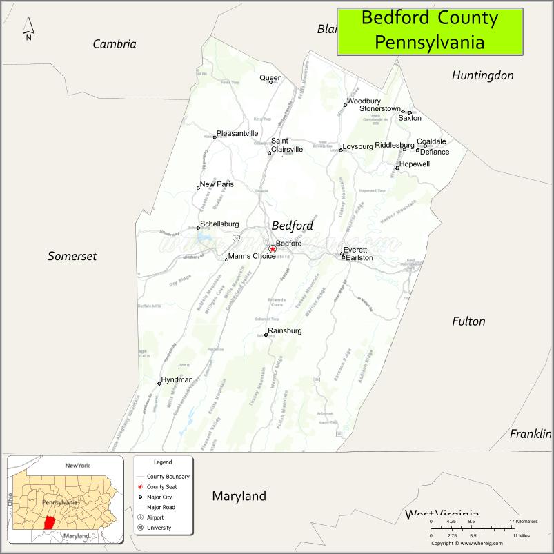
About Bedford County Map, Pennsylvania: The map showing the county boundary, county seat, major cities, highways, water bodies and neighbouring counties.
Pennsylvania Related Links
About Bedford County, Pennsylvania
Bedford County is a county located in the U.S. state of Pennsylvania. It's county seat is Bedford. As per 2020 census, the population of Bedford County is 47461 people and population density is square miles. According to the United States Census Bureau, the county has a total area of 1,015 sq mi (2,629 km2). Bedford County was established on 1771.
Facts about Bedford County, Pennsylvania
| Country | United States |
| State | Pennsylvania |
| Region | South Central Pennsylvania |
| County Seat | Bedford |
| Named After | John Russell, 4th Duke of Bedford |
| Established | 1771 |
| Organized | 1771 |
| Coordinates | 40.0067° N, 78.4903° W |
| Total Area | 1,017 sq mi |
| Land Area | 1,012 sq mi |
| Water Area | 5 sq mi |
| Population (2020 Census) | 47,577 |
| Population Rank | Smaller county in Pennsylvania |
| Major City | Bedford |
| Main Industries | Agriculture, Manufacturing, Tourism, Healthcare |
| Major Airport | Bedford County Airport (HMZ) |
| Time Zone | Eastern Time (UTC−05:00) |
| Known For | Allegheny Mountains, Bedford Springs, Historic inns |
| Website | https://www.bedfordcountypa.org |
Top Attractions in Bedford County, Pennsylvania
- Bedford Springs Resort – Historic resort and golf.
- Fort Bedford Museum – French and Indian War history.
- Old Bedford Village – Living history museum.
- Shawnee State Park – Hiking and lake recreation.
- Blue Knob State Park – Skiing and mountain views.
- Bedford County Covered Bridges – Scenic historic bridges.
- Juniata River – Fishing and paddling.
- Down River Golf Course – Riverside golf course.
- Anderson House Museum – Local history exhibits.
- Ridge and Valley Scenic Byway – Mountain driving route.
- Bedford Historic District – Shops and architecture.
- Evansburg Covered Bridge – Historic wooden bridge.
Cities & Towns in Bedford County, Pennsylvania
Bedford, Everett, Hopewell, Saxton, Hyndman, Manns Choice, Rainsburg, Schellsburg, New Baltimore, Rockwood, Raystown, Pleasantville
- Adams County Map
- Allegheny County Map
- Armstrong County Map
- Beaver County Map
- Bedford County Map
- Berks County Map
- Blair County Map
- Bradford County Map
- Bucks County Map
- Butler County Map
- Cambria County Map
- Cameron County Map
- Carbon County Map
- Centre County Map
- Chester County Map
- Clarion County Map
- Clearfield County Map
- Clinton County Map
- Columbia County Map
- Crawford County Map
- Cumberland County Map
- Dauphin County Map
- Delaware County Map
- Elk County Map
- Erie County Map
- Fayette County Map
- Forest County Map
- Franklin County Map
- Fulton County Map
- Greene County Map
- Huntingdon County Map
- Indiana County Map
- Jefferson County Map
- Juniata County Map
- Lackawanna County Map
- Lancaster County Map
- Lawrence County Map
- Lebanon County Map
- Lehigh County Map
- Luzerne County Map
- Lycoming County Map
- McKean County Map
- Mercer County Map
- Mifflin County Map
- Monroe County Map
- Montgomery County Map
- Montour County Map
- Northampton County Map
- Northumberland County Map
- Perry County Map
- Philadelphia County Map
- Pike County Map
- Potter County Map
- Schuylkill County Map
- Snyder County Map
- Somerset County Map
- Sullivan County Map
- Susquehanna County Map
- Tioga County Map
- Union County Map
- Venango County Map
- Warren County Map
- Washington County Map
- Wayne County Map
- Westmoreland County Map
- Wyoming County Map
- York County Map
- Alabama Counties
- Alaska boroughs
- Arizona Counties
- Arkansas Counties
- California County Map
- Colorado Counties
- Connecticut Counties
- Delaware Counties
- Florida County Map
- Georgia County Map
- Hawaii Counties
- Idaho Counties
- Illinois Counties
- Indiana Counties
- Iowa Counties
- Kansas Counties
- Kentucky Counties
- Louisiana Counties
- Maine Counties
- Maryland Counties
- Massachusetts Counties
- Michigan County Map
- Minnesota Counties
- Mississippi Counties
- Missouri Counties
- Montana Counties
- Nebraska Counties
- Nevada Counties
- New York Counties
- New Hampshire Counties
- New Jersey Counties
- New Mexico Counties
- North Carolina Counties
- North Dakota Counties
- Ohio County Map
- Oklahoma Counties
- Oregon Counties
- Pennsylvania Counties
- Rhode Island Counties
- South Carolina Counties
- South Dakota Counties
- Map of Tennessee
- Texas County Map
- Utah Counties
- Vermont Counties
- Virginia Counties
- Washington Counties
- West Virginia Counties
- Wisconsin Counties
- Wyoming Counties