Written and Fact-checked by Whereig Editors | Updated On: May 01, 2026, 13:37 ET
Map of Lancaster County - Lancaster County is a county located in the U.S. state of Pennsylvania. Lancaster County Map showing cities, highways, important places and water bodies. Get Where is Lancaster County located in the map, major cities in Lancaster county, population, areas, and places of interest.
Map of Lancaster County, Pennsylvania
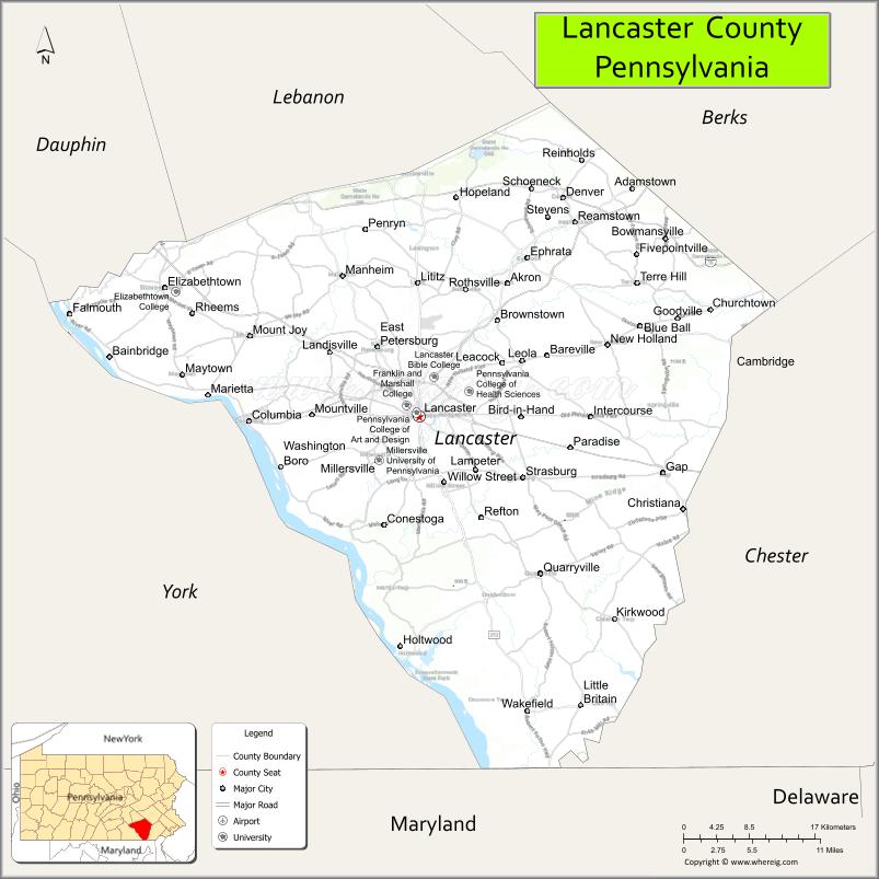
About Lancaster County Map, Pennsylvania: The map showing the county boundary, county seat, major cities, highways, water bodies and neighbouring counties.
Pennsylvania Related Links
About Lancaster County, Pennsylvania
Lancaster County is a county located in the U.S. state of Pennsylvania. It's county seat is Lancaster. As per 2020 census, the population of Lancaster County is 553652 people and population density is square miles. According to the United States Census Bureau, the county has a total area of 984 sq mi (2,549 km2). Lancaster County was established on 1729.
Facts about Lancaster County, Pennsylvania
| Country | United States |
| State | Pennsylvania |
| Region | South Central Pennsylvania |
| County Seat | Lancaster |
| Named After | Lancaster, England |
| Established | 1729 |
| Organized | 1729 |
| Coordinates | 40.0420° N, 76.3060° W |
| Total Area | 984 sq mi |
| Land Area | 944 sq mi |
| Water Area | 40 sq mi |
| Population (2020 Census) | 552,984 |
| Population Rank | Sixth most populous county in Pennsylvania |
| Major City | Lancaster |
| Main Industries | Agriculture, Manufacturing, Tourism, Healthcare |
| Major Airport | Lancaster Airport (LNS) |
| Time Zone | Eastern Time (UTC−05:00) |
| Known For | Pennsylvania Dutch heritage, Amish communities, Farmland |
| Website | https://www.co.lancaster.pa.us |
Top Attractions in Lancaster County, Pennsylvania
- Amish Country – Farms, markets, and rural scenery.
- Strasburg Rail Road – Historic steam train rides.
- Dutch Wonderland – Family amusement park.
- Central Market Lancaster – Historic farmers market.
- Landis Valley Village & Farm Museum – Pennsylvania German history.
- Fulton Theatre – Historic performing arts venue.
- President James Buchanan’s Wheatland – Presidential home.
- American Music Theatre – Live concerts and shows.
- Cherry Crest Adventure Farm – Seasonal family activities.
- Susquehannock State Park – River overlooks and trails.
- Rocky Ridge County Park – Scenic overlooks and hiking.
- Historic Downtown Lancaster – Shops, dining, and culture.
Cities & Towns in Lancaster County, Pennsylvania
Lancaster, Lititz, Manheim, Ephrata, Mount Joy, Columbia, Quarryville, Elizabethtown, Strasburg, Willow Street, Marietta, Mountville, Bainbridge, Adamstown, Denver, Millersville
- Adams County Map
- Allegheny County Map
- Armstrong County Map
- Beaver County Map
- Bedford County Map
- Berks County Map
- Blair County Map
- Bradford County Map
- Bucks County Map
- Butler County Map
- Cambria County Map
- Cameron County Map
- Carbon County Map
- Centre County Map
- Chester County Map
- Clarion County Map
- Clearfield County Map
- Clinton County Map
- Columbia County Map
- Crawford County Map
- Cumberland County Map
- Dauphin County Map
- Delaware County Map
- Elk County Map
- Erie County Map
- Fayette County Map
- Forest County Map
- Franklin County Map
- Fulton County Map
- Greene County Map
- Huntingdon County Map
- Indiana County Map
- Jefferson County Map
- Juniata County Map
- Lackawanna County Map
- Lancaster County Map
- Lawrence County Map
- Lebanon County Map
- Lehigh County Map
- Luzerne County Map
- Lycoming County Map
- McKean County Map
- Mercer County Map
- Mifflin County Map
- Monroe County Map
- Montgomery County Map
- Montour County Map
- Northampton County Map
- Northumberland County Map
- Perry County Map
- Philadelphia County Map
- Pike County Map
- Potter County Map
- Schuylkill County Map
- Snyder County Map
- Somerset County Map
- Sullivan County Map
- Susquehanna County Map
- Tioga County Map
- Union County Map
- Venango County Map
- Warren County Map
- Washington County Map
- Wayne County Map
- Westmoreland County Map
- Wyoming County Map
- York County Map
- Alabama Counties
- Alaska boroughs
- Arizona Counties
- Arkansas Counties
- California County Map
- Colorado Counties
- Connecticut Counties
- Delaware Counties
- Florida County Map
- Georgia County Map
- Hawaii Counties
- Idaho Counties
- Illinois Counties
- Indiana Counties
- Iowa Counties
- Kansas Counties
- Kentucky Counties
- Louisiana Counties
- Maine Counties
- Maryland Counties
- Massachusetts Counties
- Michigan County Map
- Minnesota Counties
- Mississippi Counties
- Missouri Counties
- Montana Counties
- Nebraska Counties
- Nevada Counties
- New York Counties
- New Hampshire Counties
- New Jersey Counties
- New Mexico Counties
- North Carolina Counties
- North Dakota Counties
- Ohio County Map
- Oklahoma Counties
- Oregon Counties
- Pennsylvania Counties
- Rhode Island Counties
- South Carolina Counties
- South Dakota Counties
- Map of Tennessee
- Texas County Map
- Utah Counties
- Vermont Counties
- Virginia Counties
- Washington Counties
- West Virginia Counties
- Wisconsin Counties
- Wyoming Counties