Written and Fact-checked by Whereig Editors | Updated On: May 01, 2026, 13:37 ET
Map of Monroe County - Monroe County is a county located in the U.S. state of Pennsylvania. Monroe County Map showing cities, highways, important places and water bodies. Get Where is Monroe County located in the map, major cities in Monroe county, population, areas, and places of interest.
Map of Monroe County, Pennsylvania
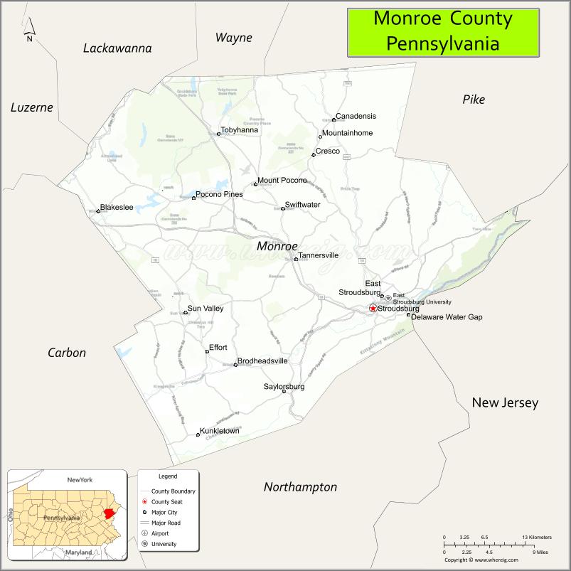
About Monroe County Map, Pennsylvania: The map showing the county boundary, county seat, major cities, highways, water bodies and neighbouring counties.
Pennsylvania Related Links
About Monroe County, Pennsylvania
Monroe County is a county located in the U.S. state of Pennsylvania. It's county seat is Stroudsburg. As per 2020 census, the population of Monroe County is 169273 people and population density is square miles. According to the United States Census Bureau, the county has a total area of 617 sq mi (1,598 km2). Monroe County was established on 1836.
Facts about Monroe County, Pennsylvania
| Country | United States |
| State | Pennsylvania |
| Region | Northeastern Pennsylvania |
| County Seat | Stroudsburg |
| Named After | James Monroe |
| Established | 1836 |
| Organized | 1836 |
| Coordinates | 41.0572° N, 75.3399° W |
| Total Area | 617 sq mi |
| Land Area | 608 sq mi |
| Water Area | 9 sq mi |
| Population (2020 Census) | 169,842 |
| Population Rank | Mid-sized county in Pennsylvania |
| Major City | Stroudsburg |
| Main Industries | Tourism, Healthcare, Education, Retail |
| Major Airport | None (nearest regional airports outside county) |
| Time Zone | Eastern Time (UTC−05:00) |
| Known For | Pocono Mountains, Outdoor recreation, Resorts |
| Website | https://www.monroecountypa.gov |
Top Attractions in Monroe County, Pennsylvania
- Delaware Water Gap National Recreation Area – Scenic river and hiking.
- Stroudsburg Downtown Historic District – Shops and dining.
- Mount Airy Casino Resort – Gaming and entertainment.
- Big Pocono State Park – Mountain views and trails.
- Quiet Valley Living Historical Farm – 19th-century farm life.
- Kalahari Resorts – Indoor waterpark resort.
- Great Wolf Lodge – Family waterpark resort.
- Shawnee Mountain Ski Area – Skiing and winter sports.
- Pocono Snake and Animal Farm – Reptile exhibits.
- Cherry Valley National Wildlife Refuge – Wetlands and wildlife.
- McDade Recreational Trail – Walking and biking trail.
- Pocono Mountains Scenic Drives – Forested mountain routes.
Cities & Towns in Monroe County, Pennsylvania
Stroudsburg, East Stroudsburg, Tobyhanna, Brodheadsville, Smithfield Township, Tannersville, Bartonsville, Scotrun, Effort, Analomink, Delaware Water Gap
- Adams County Map
- Allegheny County Map
- Armstrong County Map
- Beaver County Map
- Bedford County Map
- Berks County Map
- Blair County Map
- Bradford County Map
- Bucks County Map
- Butler County Map
- Cambria County Map
- Cameron County Map
- Carbon County Map
- Centre County Map
- Chester County Map
- Clarion County Map
- Clearfield County Map
- Clinton County Map
- Columbia County Map
- Crawford County Map
- Cumberland County Map
- Dauphin County Map
- Delaware County Map
- Elk County Map
- Erie County Map
- Fayette County Map
- Forest County Map
- Franklin County Map
- Fulton County Map
- Greene County Map
- Huntingdon County Map
- Indiana County Map
- Jefferson County Map
- Juniata County Map
- Lackawanna County Map
- Lancaster County Map
- Lawrence County Map
- Lebanon County Map
- Lehigh County Map
- Luzerne County Map
- Lycoming County Map
- McKean County Map
- Mercer County Map
- Mifflin County Map
- Monroe County Map
- Montgomery County Map
- Montour County Map
- Northampton County Map
- Northumberland County Map
- Perry County Map
- Philadelphia County Map
- Pike County Map
- Potter County Map
- Schuylkill County Map
- Snyder County Map
- Somerset County Map
- Sullivan County Map
- Susquehanna County Map
- Tioga County Map
- Union County Map
- Venango County Map
- Warren County Map
- Washington County Map
- Wayne County Map
- Westmoreland County Map
- Wyoming County Map
- York County Map
- Alabama Counties
- Alaska boroughs
- Arizona Counties
- Arkansas Counties
- California County Map
- Colorado Counties
- Connecticut Counties
- Delaware Counties
- Florida County Map
- Georgia County Map
- Hawaii Counties
- Idaho Counties
- Illinois Counties
- Indiana Counties
- Iowa Counties
- Kansas Counties
- Kentucky Counties
- Louisiana Counties
- Maine Counties
- Maryland Counties
- Massachusetts Counties
- Michigan County Map
- Minnesota Counties
- Mississippi Counties
- Missouri Counties
- Montana Counties
- Nebraska Counties
- Nevada Counties
- New York Counties
- New Hampshire Counties
- New Jersey Counties
- New Mexico Counties
- North Carolina Counties
- North Dakota Counties
- Ohio County Map
- Oklahoma Counties
- Oregon Counties
- Pennsylvania Counties
- Rhode Island Counties
- South Carolina Counties
- South Dakota Counties
- Map of Tennessee
- Texas County Map
- Utah Counties
- Vermont Counties
- Virginia Counties
- Washington Counties
- West Virginia Counties
- Wisconsin Counties
- Wyoming Counties