Written and Fact-checked by Whereig Editors | Updated On: May 01, 2026, 13:37 ET
Map of Luzerne County - Luzerne County is a county located in the U.S. state of Pennsylvania. Luzerne County Map showing cities, highways, important places and water bodies. Get Where is Luzerne County located in the map, major cities in Luzerne county, population, areas, and places of interest.
Map of Luzerne County, Pennsylvania
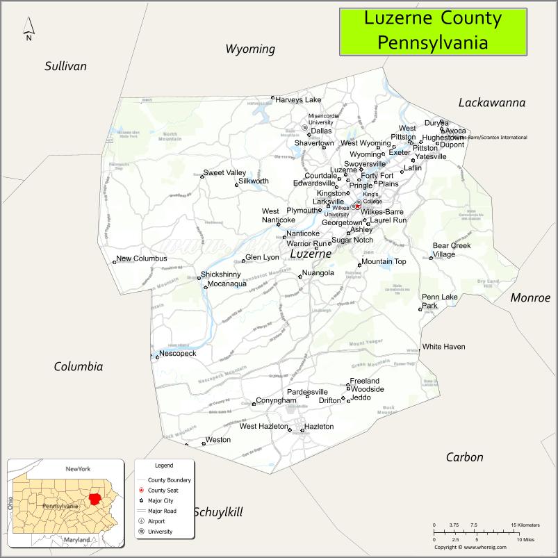
About Luzerne County Map, Pennsylvania: The map showing the county boundary, county seat, major cities, highways, water bodies and neighbouring counties.
Pennsylvania Related Links
About Luzerne County, Pennsylvania
Luzerne County is a county located in the U.S. state of Pennsylvania. It's county seat is Wilkes-Barre. As per 2020 census, the population of Luzerne County is 326053 people and population density is square miles. According to the United States Census Bureau, the county has a total area of 907 sq mi (2,349 km2). Luzerne County was established on 1786.
Facts about Luzerne County, Pennsylvania
| Country | United States |
| State | Pennsylvania |
| Region | Northeastern Pennsylvania |
| County Seat | Wilkes-Barre |
| Named After | Chevalier de la Luzerne |
| Established | 1786 |
| Organized | 1786 |
| Coordinates | 41.1725° N, 75.8764° W |
| Total Area | 912 sq mi |
| Land Area | 890 sq mi |
| Water Area | 22 sq mi |
| Population (2020 Census) | 325,594 |
| Population Rank | Mid-sized county in Pennsylvania |
| Major City | Wilkes-Barre |
| Main Industries | Healthcare, Education, Manufacturing, Transportation |
| Major Airport | Wilkes-Barre/Scranton International Airport (AVP) |
| Time Zone | Eastern Time (UTC−05:00) |
| Known For | Anthracite coal history, Wyoming Valley, Susquehanna River |
| Website | https://www.luzernecounty.org |
Top Attractions in Luzerne County, Pennsylvania
- Mohegan Pennsylvania – Casino, entertainment, and dining.
- Seven Tubs Nature Area – Rock formations and hiking trails.
- Frances Slocum State Park – Lake recreation and camping.
- Eckley Miners’ Village – Historic coal town museum.
- Kirby Park – Riverfront park and walking paths.
- Mountain Top Arboretum – Gardens and nature trails.
- Wyoming Valley Mall – Shopping and dining.
- F.M. Kirby Center for the Performing Arts – Concerts and theater.
- Susquehanna River – Fishing and scenic views.
- Hollenback Park – Trails and waterfalls.
- Anthracite Heritage Museum (nearby) – Coal region history.
- Wilkes-Barre Downtown Historic District – Shops and local culture.
Cities & Towns in Luzerne County, Pennsylvania
Wilkes-Barre, Hazleton, Kingston, Nanticoke, Pittston, West Hazleton, Ashley, Swoyersville, Plains, Dallas, Forty Fort, Freeland, Shickshinny, Conyngham, Sugar Notch, Plymouth, Hanover Township
- Adams County Map
- Allegheny County Map
- Armstrong County Map
- Beaver County Map
- Bedford County Map
- Berks County Map
- Blair County Map
- Bradford County Map
- Bucks County Map
- Butler County Map
- Cambria County Map
- Cameron County Map
- Carbon County Map
- Centre County Map
- Chester County Map
- Clarion County Map
- Clearfield County Map
- Clinton County Map
- Columbia County Map
- Crawford County Map
- Cumberland County Map
- Dauphin County Map
- Delaware County Map
- Elk County Map
- Erie County Map
- Fayette County Map
- Forest County Map
- Franklin County Map
- Fulton County Map
- Greene County Map
- Huntingdon County Map
- Indiana County Map
- Jefferson County Map
- Juniata County Map
- Lackawanna County Map
- Lancaster County Map
- Lawrence County Map
- Lebanon County Map
- Lehigh County Map
- Luzerne County Map
- Lycoming County Map
- McKean County Map
- Mercer County Map
- Mifflin County Map
- Monroe County Map
- Montgomery County Map
- Montour County Map
- Northampton County Map
- Northumberland County Map
- Perry County Map
- Philadelphia County Map
- Pike County Map
- Potter County Map
- Schuylkill County Map
- Snyder County Map
- Somerset County Map
- Sullivan County Map
- Susquehanna County Map
- Tioga County Map
- Union County Map
- Venango County Map
- Warren County Map
- Washington County Map
- Wayne County Map
- Westmoreland County Map
- Wyoming County Map
- York County Map
- Alabama Counties
- Alaska boroughs
- Arizona Counties
- Arkansas Counties
- California County Map
- Colorado Counties
- Connecticut Counties
- Delaware Counties
- Florida County Map
- Georgia County Map
- Hawaii Counties
- Idaho Counties
- Illinois Counties
- Indiana Counties
- Iowa Counties
- Kansas Counties
- Kentucky Counties
- Louisiana Counties
- Maine Counties
- Maryland Counties
- Massachusetts Counties
- Michigan County Map
- Minnesota Counties
- Mississippi Counties
- Missouri Counties
- Montana Counties
- Nebraska Counties
- Nevada Counties
- New York Counties
- New Hampshire Counties
- New Jersey Counties
- New Mexico Counties
- North Carolina Counties
- North Dakota Counties
- Ohio County Map
- Oklahoma Counties
- Oregon Counties
- Pennsylvania Counties
- Rhode Island Counties
- South Carolina Counties
- South Dakota Counties
- Map of Tennessee
- Texas County Map
- Utah Counties
- Vermont Counties
- Virginia Counties
- Washington Counties
- West Virginia Counties
- Wisconsin Counties
- Wyoming Counties