Written and Fact-checked by Whereig Editors | Updated On: May 01, 2026, 13:37 ET
Map of Lycoming County - Lycoming County is a county located in the U.S. state of Pennsylvania. Lycoming County Map showing cities, highways, important places and water bodies. Get Where is Lycoming County located in the map, major cities in Lycoming county, population, areas, and places of interest.
Map of Lycoming County, Pennsylvania
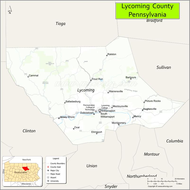
About Lycoming County Map, Pennsylvania: The map showing the county boundary, county seat, major cities, highways, water bodies and neighbouring counties.
Pennsylvania Related Links
About Lycoming County, Pennsylvania
Lycoming County is a county located in the U.S. state of Pennsylvania. It's county seat is Williamsport. As per 2020 census, the population of Lycoming County is 113605 people and population density is square miles. According to the United States Census Bureau, the county has a total area of 1,244 sq mi (3,222 km2). Lycoming County was established on 1795.
Facts about Lycoming County, Pennsylvania
| Country | United States |
| State | Pennsylvania |
| Region | North Central Pennsylvania |
| County Seat | Williamsport |
| Named After | Lycoming Creek |
| Established | 1795 |
| Organized | 1795 |
| Coordinates | 41.2412° N, 77.0011° W |
| Total Area | 1,244 sq mi |
| Land Area | 1,229 sq mi |
| Water Area | 15 sq mi |
| Population (2020 Census) | 114,188 |
| Population Rank | Mid-sized county in Pennsylvania |
| Major City | Williamsport |
| Main Industries | Manufacturing, Healthcare, Education, Forestry |
| Major Airport | Williamsport Regional Airport (IPT) |
| Time Zone | Eastern Time (UTC−05:00) |
| Known For | Little League World Series, Susquehanna River, Outdoor recreation |
| Website | https://www.lyco.org |
Top Attractions in Lycoming County, Pennsylvania
- Worlds End State Park – Canyon views and hiking trails.
- Little League Baseball World Series Complex – Youth baseball landmark.
- Lycoming Creek – Fishing and scenic paddling.
- Williamsport Historic District – Architecture and local shops.
- Peter J. McGovern Little League Museum – Little League history.
- Montoursville Historic District – Victorian homes and charm.
- Susquehanna Riverwalk – Riverfront walking path.
- Ricketts Glen State Park (nearby) – Waterfalls and hiking.
- Pennsylvania Lumber Museum (nearby) – Logging history exhibits.
- Bald Eagle State Forest – Forest trails and wildlife.
- Hepburn Street Historic Area – Historic homes and streets.
- Indian Park – City park and community events.
Cities & Towns in Lycoming County, Pennsylvania
Williamsport, Montoursville, Jersey Shore, Muncy, Hughesville, South Williamsport, Linden, Avis, Cogan House, Trout Run, Ralston, Picture Rocks, Jersey Shore Township
- Adams County Map
- Allegheny County Map
- Armstrong County Map
- Beaver County Map
- Bedford County Map
- Berks County Map
- Blair County Map
- Bradford County Map
- Bucks County Map
- Butler County Map
- Cambria County Map
- Cameron County Map
- Carbon County Map
- Centre County Map
- Chester County Map
- Clarion County Map
- Clearfield County Map
- Clinton County Map
- Columbia County Map
- Crawford County Map
- Cumberland County Map
- Dauphin County Map
- Delaware County Map
- Elk County Map
- Erie County Map
- Fayette County Map
- Forest County Map
- Franklin County Map
- Fulton County Map
- Greene County Map
- Huntingdon County Map
- Indiana County Map
- Jefferson County Map
- Juniata County Map
- Lackawanna County Map
- Lancaster County Map
- Lawrence County Map
- Lebanon County Map
- Lehigh County Map
- Luzerne County Map
- Lycoming County Map
- McKean County Map
- Mercer County Map
- Mifflin County Map
- Monroe County Map
- Montgomery County Map
- Montour County Map
- Northampton County Map
- Northumberland County Map
- Perry County Map
- Philadelphia County Map
- Pike County Map
- Potter County Map
- Schuylkill County Map
- Snyder County Map
- Somerset County Map
- Sullivan County Map
- Susquehanna County Map
- Tioga County Map
- Union County Map
- Venango County Map
- Warren County Map
- Washington County Map
- Wayne County Map
- Westmoreland County Map
- Wyoming County Map
- York County Map
- Alabama Counties
- Alaska boroughs
- Arizona Counties
- Arkansas Counties
- California County Map
- Colorado Counties
- Connecticut Counties
- Delaware Counties
- Florida County Map
- Georgia County Map
- Hawaii Counties
- Idaho Counties
- Illinois Counties
- Indiana Counties
- Iowa Counties
- Kansas Counties
- Kentucky Counties
- Louisiana Counties
- Maine Counties
- Maryland Counties
- Massachusetts Counties
- Michigan County Map
- Minnesota Counties
- Mississippi Counties
- Missouri Counties
- Montana Counties
- Nebraska Counties
- Nevada Counties
- New York Counties
- New Hampshire Counties
- New Jersey Counties
- New Mexico Counties
- North Carolina Counties
- North Dakota Counties
- Ohio County Map
- Oklahoma Counties
- Oregon Counties
- Pennsylvania Counties
- Rhode Island Counties
- South Carolina Counties
- South Dakota Counties
- Map of Tennessee
- Texas County Map
- Utah Counties
- Vermont Counties
- Virginia Counties
- Washington Counties
- West Virginia Counties
- Wisconsin Counties
- Wyoming Counties