Written and Fact-checked by Whereig Editors | Updated On: May 01, 2026, 13:37 ET
Map of Sullivan County - Sullivan County is a county located in the U.S. state of Pennsylvania. Sullivan County Map showing cities, highways, important places and water bodies. Get Where is Sullivan County located in the map, major cities in Sullivan county, population, areas, and places of interest.
Map of Sullivan County, Pennsylvania
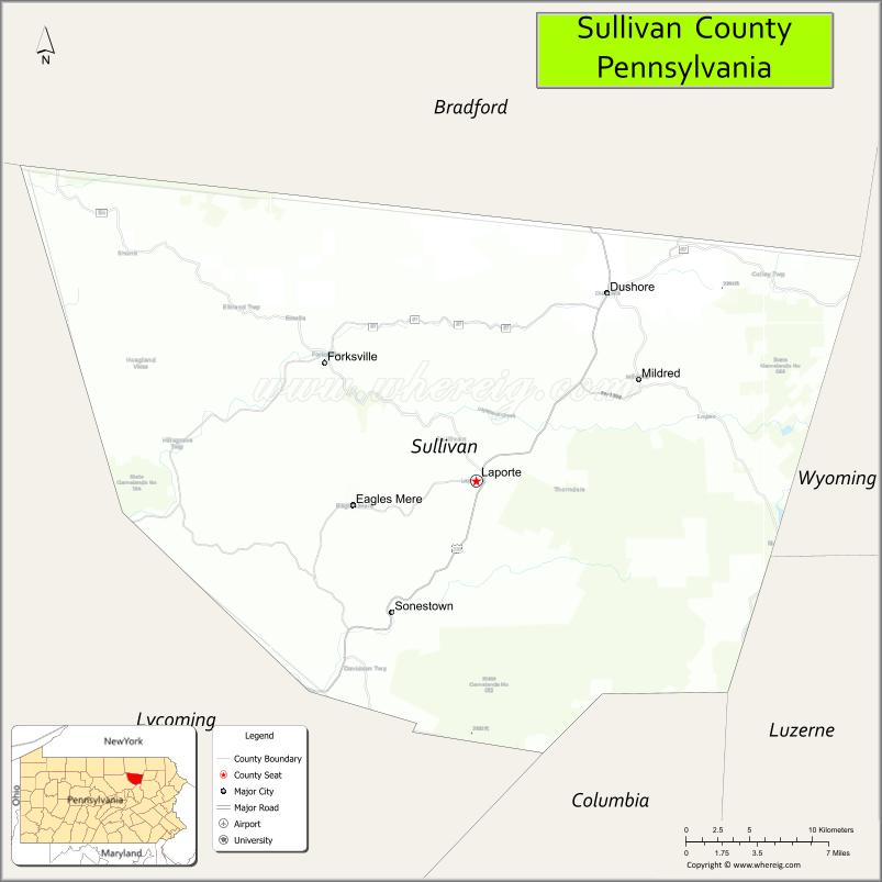
About Sullivan County Map, Pennsylvania: The map showing the county boundary, county seat, major cities, highways, water bodies and neighbouring counties.
Pennsylvania Related Links
About Sullivan County, Pennsylvania
Sullivan County is a county located in the U.S. state of Pennsylvania. It's county seat is Laporte. As per 2020 census, the population of Sullivan County is 5868 people and population density is square miles. According to the United States Census Bureau, the county has a total area of 452 sq mi (1,171 km2). Sullivan County was established on 1847.
Facts about Sullivan County, Pennsylvania
| Country | United States |
| State | Pennsylvania |
| Region | Northeastern Pennsylvania |
| County Seat | Laporte |
| Named After | John Sullivan |
| Established | 1847 |
| Organized | 1847 |
| Coordinates | 41.4346° N, 76.5127° W |
| Total Area | 452 sq mi |
| Land Area | 450 sq mi |
| Water Area | 2 sq mi |
| Population (2020 Census) | 6,071 |
| Population Rank | Least populous county in Pennsylvania |
| Major City | Laporte |
| Main Industries | Forestry, Tourism, Agriculture |
| Major Airport | None (nearest regional airports outside county) |
| Time Zone | Eastern Time (UTC−05:00) |
| Known For | Endless Mountains, State forests, Outdoor recreation |
| Website | https://www.sullivancounty-pa.us |
Top Attractions in Sullivan County, Pennsylvania
- Worlds End State Park – Canyon views and hiking trails.
- Loyalsock State Forest – Forest roads and waterfalls.
- High Knob Overlook – Scenic mountain viewpoint.
- Haystacks – Rock formations along Loyalsock Creek.
- Eagles Mere Historic District – Victorian-era mountain village.
- Eagles Mere Lake – Swimming and lakeside recreation.
- Sullivan County Historical Society – Local history exhibits.
- Loyalsock Creek – Fishing and paddling.
- Laporte Courthouse Square – County seat and park area.
- Painter Den Falls – Scenic waterfall hike.
- Forksville Covered Bridge – Historic wooden bridge.
- Hillsgrove Township Scenic Area – Rural landscapes and views.
Cities & Towns in Sullivan County, Pennsylvania
Laporte, Dushore, Eagles Mere, Hillsgrove, Forks Township, Cherry Township, Davidson Township, Forksville
- Adams County Map
- Allegheny County Map
- Armstrong County Map
- Beaver County Map
- Bedford County Map
- Berks County Map
- Blair County Map
- Bradford County Map
- Bucks County Map
- Butler County Map
- Cambria County Map
- Cameron County Map
- Carbon County Map
- Centre County Map
- Chester County Map
- Clarion County Map
- Clearfield County Map
- Clinton County Map
- Columbia County Map
- Crawford County Map
- Cumberland County Map
- Dauphin County Map
- Delaware County Map
- Elk County Map
- Erie County Map
- Fayette County Map
- Forest County Map
- Franklin County Map
- Fulton County Map
- Greene County Map
- Huntingdon County Map
- Indiana County Map
- Jefferson County Map
- Juniata County Map
- Lackawanna County Map
- Lancaster County Map
- Lawrence County Map
- Lebanon County Map
- Lehigh County Map
- Luzerne County Map
- Lycoming County Map
- McKean County Map
- Mercer County Map
- Mifflin County Map
- Monroe County Map
- Montgomery County Map
- Montour County Map
- Northampton County Map
- Northumberland County Map
- Perry County Map
- Philadelphia County Map
- Pike County Map
- Potter County Map
- Schuylkill County Map
- Snyder County Map
- Somerset County Map
- Sullivan County Map
- Susquehanna County Map
- Tioga County Map
- Union County Map
- Venango County Map
- Warren County Map
- Washington County Map
- Wayne County Map
- Westmoreland County Map
- Wyoming County Map
- York County Map
- Alabama Counties
- Alaska boroughs
- Arizona Counties
- Arkansas Counties
- California County Map
- Colorado Counties
- Connecticut Counties
- Delaware Counties
- Florida County Map
- Georgia County Map
- Hawaii Counties
- Idaho Counties
- Illinois Counties
- Indiana Counties
- Iowa Counties
- Kansas Counties
- Kentucky Counties
- Louisiana Counties
- Maine Counties
- Maryland Counties
- Massachusetts Counties
- Michigan County Map
- Minnesota Counties
- Mississippi Counties
- Missouri Counties
- Montana Counties
- Nebraska Counties
- Nevada Counties
- New York Counties
- New Hampshire Counties
- New Jersey Counties
- New Mexico Counties
- North Carolina Counties
- North Dakota Counties
- Ohio County Map
- Oklahoma Counties
- Oregon Counties
- Pennsylvania Counties
- Rhode Island Counties
- South Carolina Counties
- South Dakota Counties
- Map of Tennessee
- Texas County Map
- Utah Counties
- Vermont Counties
- Virginia Counties
- Washington Counties
- West Virginia Counties
- Wisconsin Counties
- Wyoming Counties