Written and Fact-checked by Whereig Editors | Updated On: May 01, 2026, 13:37 ET
Map of Wayne County - Wayne County is a county located in the U.S. state of Pennsylvania. Wayne County Map showing cities, highways, important places and water bodies. Get Where is Wayne County located in the map, major cities in Wayne county, population, areas, and places of interest.
Map of Wayne County, Pennsylvania
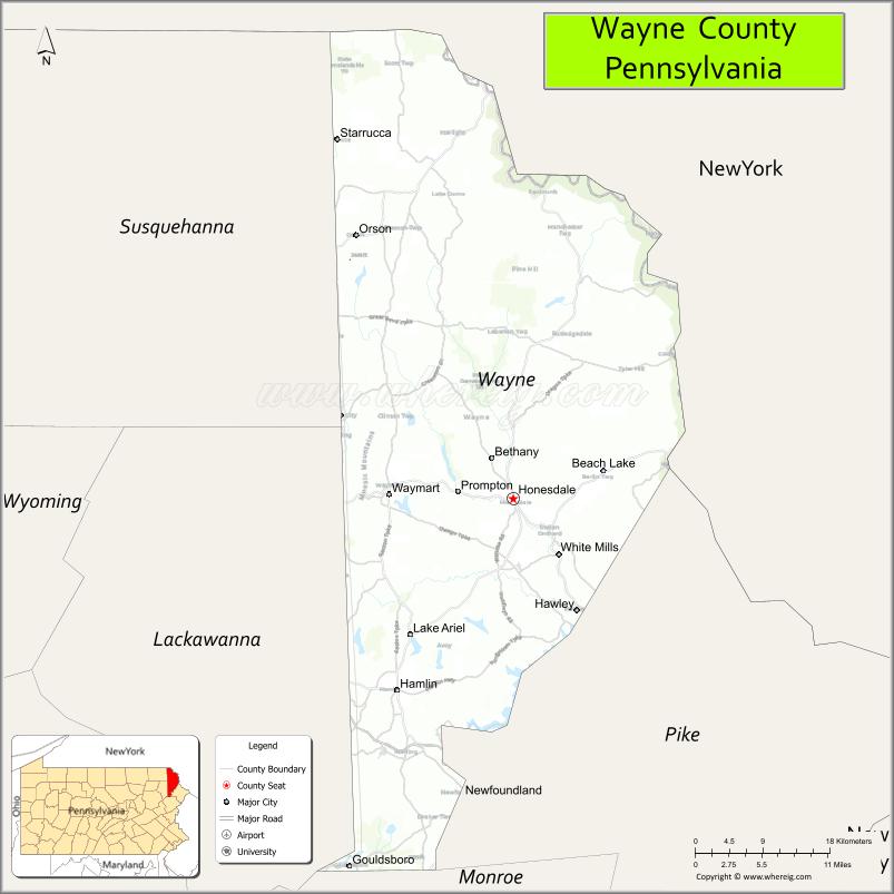
About Wayne County Map, Pennsylvania: The map showing the county boundary, county seat, major cities, highways, water bodies and neighbouring counties.
Pennsylvania Related Links
About Wayne County, Pennsylvania
Wayne County is a county located in the U.S. state of Pennsylvania. It's county seat is Honesdale. As per 2020 census, the population of Wayne County is 51431 people and population density is square miles. According to the United States Census Bureau, the county has a total area of 751 sq mi (1,945 km2). Wayne County was established on 1798.
Facts about Wayne County, Pennsylvania
| Country | United States |
| State | Pennsylvania |
| Region | Northeastern Pennsylvania |
| County Seat | Honesdale |
| Named After | General Anthony Wayne |
| Established | 1798 |
| Organized | 1798 |
| Coordinates | 41.6731° N, 75.2471° W |
| Total Area | 751 sq mi |
| Land Area | 735 sq mi |
| Water Area | 16 sq mi |
| Population (2020 Census) | 51,155 |
| Population Rank | Smaller county in Pennsylvania |
| Major City | Honesdale |
| Main Industries | Tourism, Healthcare, Agriculture, Retail |
| Major Airport | None (nearest regional airports outside county) |
| Time Zone | Eastern Time (UTC−05:00) |
| Known For | Delaware River, Pocono Mountains, Scenic railroads |
| Website | https://www.waynecountypa.gov |
Top Attractions in Wayne County, Pennsylvania
- Delaware River – Scenic river for rafting and fishing.
- Honesdale Historic District – Shops and small-town charm.
- Delaware & Hudson Canal Museum – Canal and transportation history.
- Promised Land State Park – Lakes, camping, and hiking.
- Lake Wallenpaupack (nearby) – Boating and waterfront recreation.
- Stourbridge Line – Scenic train excursions.
- Wayne County Historical Society Museum – Local history exhibits.
- Honesdale Roots & Rhythm Music Festival – Annual music event.
- Upper Delaware Scenic Byway – Riverfront driving route.
- Irving Cliff – Scenic overlook above Honesdale.
- Dyberry Creek – Fishing and nature scenery.
- Hawley Silk Mill (nearby) – Shops, dining, and events.
Cities & Towns in Wayne County, Pennsylvania
Honesdale, Hawley, Prompton, Bethany, Hamlin, Texas, Newfoundland, Lake Ariel, Sterling, Dyberry, Cherry Ridge, Orson, Newfoundland Township
- Adams County Map
- Allegheny County Map
- Armstrong County Map
- Beaver County Map
- Bedford County Map
- Berks County Map
- Blair County Map
- Bradford County Map
- Bucks County Map
- Butler County Map
- Cambria County Map
- Cameron County Map
- Carbon County Map
- Centre County Map
- Chester County Map
- Clarion County Map
- Clearfield County Map
- Clinton County Map
- Columbia County Map
- Crawford County Map
- Cumberland County Map
- Dauphin County Map
- Delaware County Map
- Elk County Map
- Erie County Map
- Fayette County Map
- Forest County Map
- Franklin County Map
- Fulton County Map
- Greene County Map
- Huntingdon County Map
- Indiana County Map
- Jefferson County Map
- Juniata County Map
- Lackawanna County Map
- Lancaster County Map
- Lawrence County Map
- Lebanon County Map
- Lehigh County Map
- Luzerne County Map
- Lycoming County Map
- McKean County Map
- Mercer County Map
- Mifflin County Map
- Monroe County Map
- Montgomery County Map
- Montour County Map
- Northampton County Map
- Northumberland County Map
- Perry County Map
- Philadelphia County Map
- Pike County Map
- Potter County Map
- Schuylkill County Map
- Snyder County Map
- Somerset County Map
- Sullivan County Map
- Susquehanna County Map
- Tioga County Map
- Union County Map
- Venango County Map
- Warren County Map
- Washington County Map
- Wayne County Map
- Westmoreland County Map
- Wyoming County Map
- York County Map
- Alabama Counties
- Alaska boroughs
- Arizona Counties
- Arkansas Counties
- California County Map
- Colorado Counties
- Connecticut Counties
- Delaware Counties
- Florida County Map
- Georgia County Map
- Hawaii Counties
- Idaho Counties
- Illinois Counties
- Indiana Counties
- Iowa Counties
- Kansas Counties
- Kentucky Counties
- Louisiana Counties
- Maine Counties
- Maryland Counties
- Massachusetts Counties
- Michigan County Map
- Minnesota Counties
- Mississippi Counties
- Missouri Counties
- Montana Counties
- Nebraska Counties
- Nevada Counties
- New York Counties
- New Hampshire Counties
- New Jersey Counties
- New Mexico Counties
- North Carolina Counties
- North Dakota Counties
- Ohio County Map
- Oklahoma Counties
- Oregon Counties
- Pennsylvania Counties
- Rhode Island Counties
- South Carolina Counties
- South Dakota Counties
- Map of Tennessee
- Texas County Map
- Utah Counties
- Vermont Counties
- Virginia Counties
- Washington Counties
- West Virginia Counties
- Wisconsin Counties
- Wyoming Counties