Written and Fact-checked by Whereig Editors | Updated On: May 01, 2026, 13:37 ET
Map of York County - York County is a county located in the U.S. state of Pennsylvania. York County Map showing cities, highways, important places and water bodies. Get Where is York County located in the map, major cities in York county, population, areas, and places of interest.
Map of York County, Pennsylvania
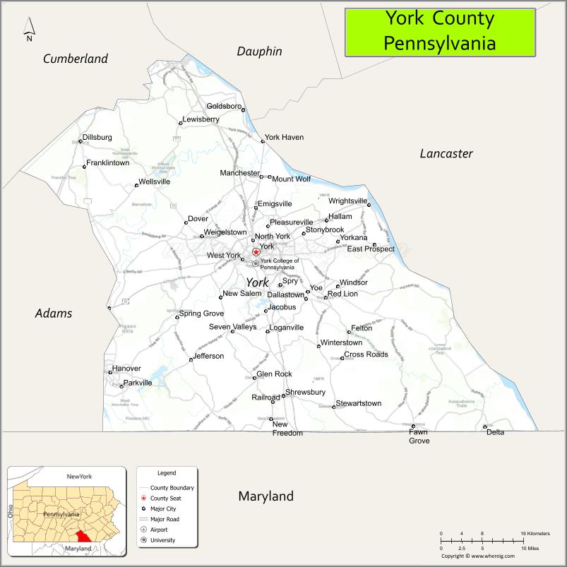
About York County Map, Pennsylvania: The map showing the county boundary, county seat, major cities, highways, water bodies and neighbouring counties.
Pennsylvania Related Links
About York County, Pennsylvania
York County is a county located in the U.S. state of Pennsylvania. It's county seat is York. As per 2020 census, the population of York County is 458696 people and population density is square miles. According to the United States Census Bureau, the county has a total area of 910 sq mi (2,357 km2). York County was established on 1749.
Facts about York County, Pennsylvania
| Country | United States |
| State | Pennsylvania |
| Region | South Central Pennsylvania |
| County Seat | York |
| Named After | York, England |
| Established | 1749 |
| Organized | 1749 |
| Coordinates | 39.9626° N, 76.7277° W |
| Total Area | 911 sq mi |
| Land Area | 903 sq mi |
| Water Area | 8 sq mi |
| Population (2020 Census) | 456,438 |
| Population Rank | Seventh most populous county in Pennsylvania |
| Major City | York |
| Main Industries | Manufacturing, Healthcare, Logistics, Agriculture |
| Major Airport | York Airport (THV) |
| Time Zone | Eastern Time (UTC−05:00) |
| Known For | York Fair, Manufacturing heritage, Historic downtowns |
| Website | https://www.yorkcountypa.gov |
Top Attractions in York County, Pennsylvania
- York County Heritage Rail Trail – Walking and biking trail.
- Harley-Davidson Vehicle Operations – Motorcycle factory tours.
- Central Market York – Historic farmers market.
- Colonial Complex – Early American historic buildings.
- Codorus State Park – Lake recreation and trails.
- York Revolution Baseball (WellSpan Park) – Minor league baseball.
- Gifford Pinchot State Park – Lake and outdoor recreation.
- Hanover Historic District – Shops and small-town charm.
- National Watch & Clock Museum – Timepiece history exhibits.
- Indian Steps Museum – Native American artifacts.
- Wrightsville Historic District – River town and views.
- Susquehanna Riverlands State Park – River access and trails.
Cities & Towns in York County, Pennsylvania
York, Hanover, Dallastown, Red Lion, Spring Grove, Shrewsbury, Glen Rock, Dover, Wrightsville, Lewisberry, Manchester, Jacobus, Mount Wolf, Goldsboro, West York, East York, New Freedom, Springettsbury, Wellsville
- Adams County Map
- Allegheny County Map
- Armstrong County Map
- Beaver County Map
- Bedford County Map
- Berks County Map
- Blair County Map
- Bradford County Map
- Bucks County Map
- Butler County Map
- Cambria County Map
- Cameron County Map
- Carbon County Map
- Centre County Map
- Chester County Map
- Clarion County Map
- Clearfield County Map
- Clinton County Map
- Columbia County Map
- Crawford County Map
- Cumberland County Map
- Dauphin County Map
- Delaware County Map
- Elk County Map
- Erie County Map
- Fayette County Map
- Forest County Map
- Franklin County Map
- Fulton County Map
- Greene County Map
- Huntingdon County Map
- Indiana County Map
- Jefferson County Map
- Juniata County Map
- Lackawanna County Map
- Lancaster County Map
- Lawrence County Map
- Lebanon County Map
- Lehigh County Map
- Luzerne County Map
- Lycoming County Map
- McKean County Map
- Mercer County Map
- Mifflin County Map
- Monroe County Map
- Montgomery County Map
- Montour County Map
- Northampton County Map
- Northumberland County Map
- Perry County Map
- Philadelphia County Map
- Pike County Map
- Potter County Map
- Schuylkill County Map
- Snyder County Map
- Somerset County Map
- Sullivan County Map
- Susquehanna County Map
- Tioga County Map
- Union County Map
- Venango County Map
- Warren County Map
- Washington County Map
- Wayne County Map
- Westmoreland County Map
- Wyoming County Map
- York County Map
- Alabama Counties
- Alaska boroughs
- Arizona Counties
- Arkansas Counties
- California County Map
- Colorado Counties
- Connecticut Counties
- Delaware Counties
- Florida County Map
- Georgia County Map
- Hawaii Counties
- Idaho Counties
- Illinois Counties
- Indiana Counties
- Iowa Counties
- Kansas Counties
- Kentucky Counties
- Louisiana Counties
- Maine Counties
- Maryland Counties
- Massachusetts Counties
- Michigan County Map
- Minnesota Counties
- Mississippi Counties
- Missouri Counties
- Montana Counties
- Nebraska Counties
- Nevada Counties
- New York Counties
- New Hampshire Counties
- New Jersey Counties
- New Mexico Counties
- North Carolina Counties
- North Dakota Counties
- Ohio County Map
- Oklahoma Counties
- Oregon Counties
- Pennsylvania Counties
- Rhode Island Counties
- South Carolina Counties
- South Dakota Counties
- Map of Tennessee
- Texas County Map
- Utah Counties
- Vermont Counties
- Virginia Counties
- Washington Counties
- West Virginia Counties
- Wisconsin Counties
- Wyoming Counties