Written and Fact-checked by Whereig Editors | Updated On: May 01, 2026, 13:37 ET
Map of Carbon County - Carbon County is a county located in the U.S. state of Pennsylvania. Carbon County Map showing cities, highways, important places and water bodies. Get Where is Carbon County located in the map, major cities in Carbon county, population, areas, and places of interest.
Map of Carbon County, Pennsylvania
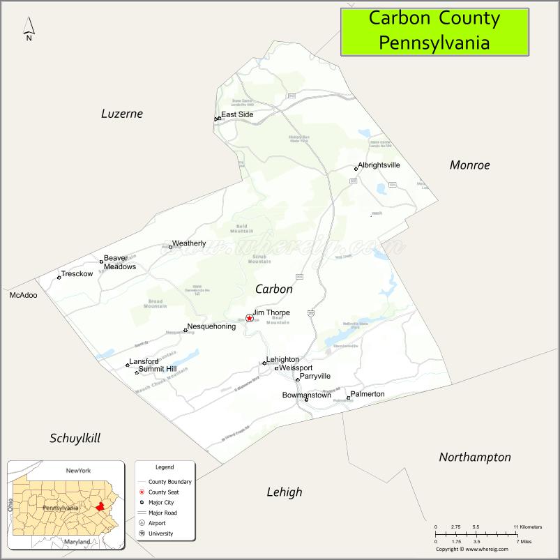
About Carbon County Map, Pennsylvania: The map showing the county boundary, county seat, major cities, highways, water bodies and neighbouring counties.
Pennsylvania Related Links
About Carbon County, Pennsylvania
Carbon County is a county located in the U.S. state of Pennsylvania. It's county seat is Jim Thorpe. As per 2020 census, the population of Carbon County is 65412 people and population density is square miles. According to the United States Census Bureau, the county has a total area of 387 sq mi (1,002 km2). Carbon County was established on 1843.
Facts about Carbon County, Pennsylvania
| Country | United States |
| State | Pennsylvania |
| Region | Northeastern Pennsylvania |
| County Seat | Jim Thorpe |
| Named After | Coal (carbon) |
| Established | 1843 |
| Organized | 1843 |
| Coordinates | 40.9187° N, 75.7077° W |
| Total Area | 387 sq mi |
| Land Area | 381 sq mi |
| Water Area | 6 sq mi |
| Population (2020 Census) | 64,491 |
| Population Rank | Smaller county in Pennsylvania |
| Major City | Jim Thorpe |
| Main Industries | Tourism, Manufacturing, Healthcare, Energy |
| Major Airport | Pocono Mountains Municipal Airport (outside county) |
| Time Zone | Eastern Time (UTC−05:00) |
| Known For | Lehigh Gorge, Coal mining history, Outdoor recreation |
| Website | https://www.carboncounty.com |
Top Attractions in Carbon County, Pennsylvania
- Lehigh Gorge State Park – Gorge trails and river views.
- Jim Thorpe Historic District – Victorian architecture and shops.
- Asa Packer Mansion Museum – Gilded Age mansion tours.
- Lehigh Gorge Scenic Railway – Scenic train rides.
- Hickory Run State Park – Boulder Field and hiking.
- Glen Onoko Falls (area) – Scenic waterfall views.
- Mauch Chunk Museum & Cultural Center – Local history exhibits.
- Bear Mountain Butterfly Sanctuary – Indoor butterfly garden.
- Switchback Railroad Trail – Historic rail-trail biking.
- Carbon County Environmental Education Center – Nature trails.
- Old Jail Museum – Historic jail and legends.
- Pohopoco Creek – Fishing and scenic views.
Cities & Towns in Carbon County, Pennsylvania
Jim Thorpe, Lehighton, Palmerton, Nesquehoning, Weatherly, East Side, Bowmanstown, Summit Hill, Lansford, Beaver Meadows, Weissport, Penn Forest, Lower Towamensing
- Adams County Map
- Allegheny County Map
- Armstrong County Map
- Beaver County Map
- Bedford County Map
- Berks County Map
- Blair County Map
- Bradford County Map
- Bucks County Map
- Butler County Map
- Cambria County Map
- Cameron County Map
- Carbon County Map
- Centre County Map
- Chester County Map
- Clarion County Map
- Clearfield County Map
- Clinton County Map
- Columbia County Map
- Crawford County Map
- Cumberland County Map
- Dauphin County Map
- Delaware County Map
- Elk County Map
- Erie County Map
- Fayette County Map
- Forest County Map
- Franklin County Map
- Fulton County Map
- Greene County Map
- Huntingdon County Map
- Indiana County Map
- Jefferson County Map
- Juniata County Map
- Lackawanna County Map
- Lancaster County Map
- Lawrence County Map
- Lebanon County Map
- Lehigh County Map
- Luzerne County Map
- Lycoming County Map
- McKean County Map
- Mercer County Map
- Mifflin County Map
- Monroe County Map
- Montgomery County Map
- Montour County Map
- Northampton County Map
- Northumberland County Map
- Perry County Map
- Philadelphia County Map
- Pike County Map
- Potter County Map
- Schuylkill County Map
- Snyder County Map
- Somerset County Map
- Sullivan County Map
- Susquehanna County Map
- Tioga County Map
- Union County Map
- Venango County Map
- Warren County Map
- Washington County Map
- Wayne County Map
- Westmoreland County Map
- Wyoming County Map
- York County Map
- Alabama Counties
- Alaska boroughs
- Arizona Counties
- Arkansas Counties
- California County Map
- Colorado Counties
- Connecticut Counties
- Delaware Counties
- Florida County Map
- Georgia County Map
- Hawaii Counties
- Idaho Counties
- Illinois Counties
- Indiana Counties
- Iowa Counties
- Kansas Counties
- Kentucky Counties
- Louisiana Counties
- Maine Counties
- Maryland Counties
- Massachusetts Counties
- Michigan County Map
- Minnesota Counties
- Mississippi Counties
- Missouri Counties
- Montana Counties
- Nebraska Counties
- Nevada Counties
- New York Counties
- New Hampshire Counties
- New Jersey Counties
- New Mexico Counties
- North Carolina Counties
- North Dakota Counties
- Ohio County Map
- Oklahoma Counties
- Oregon Counties
- Pennsylvania Counties
- Rhode Island Counties
- South Carolina Counties
- South Dakota Counties
- Map of Tennessee
- Texas County Map
- Utah Counties
- Vermont Counties
- Virginia Counties
- Washington Counties
- West Virginia Counties
- Wisconsin Counties
- Wyoming Counties