Written and Fact-checked by Whereig Editors | Updated On: May 01, 2026, 13:37 ET
Map of Armstrong County - Armstrong County is a county located in the U.S. state of Pennsylvania. Armstrong County Map showing cities, highways, important places and water bodies. Get Where is Armstrong County located in the map, major cities in Armstrong county, population, areas, and places of interest.
Map of Armstrong County, Pennsylvania
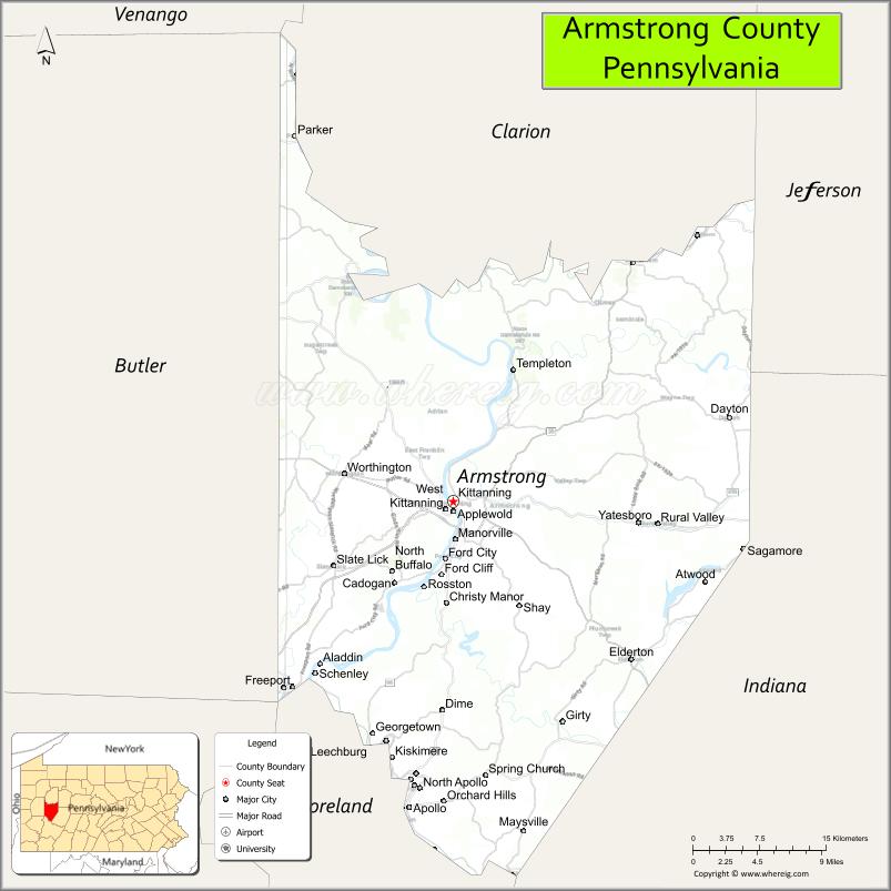
About Armstrong County Map, Pennsylvania: The map showing the county boundary, county seat, major cities, highways, water bodies and neighbouring counties.
Pennsylvania Related Links
About Armstrong County, Pennsylvania
Armstrong County is a county located in the U.S. state of Pennsylvania. It's county seat is Kittanning. As per 2020 census, the population of Armstrong County is 65093 people and population density is square miles. According to the United States Census Bureau, the county has a total area of 664 sq mi (1,720 km2). Armstrong County was established on 1800.
Facts about Armstrong County, Pennsylvania
| Country | United States |
| State | Pennsylvania |
| Region | Western Pennsylvania |
| County Seat | Kittanning |
| Named After | John Armstrong Sr. |
| Established | 1800 |
| Organized | 1800 |
| Coordinates | 40.8140° N, 79.4640° W |
| Total Area | 664 sq mi |
| Land Area | 657 sq mi |
| Water Area | 7 sq mi |
| Population (2020 Census) | 65,558 |
| Population Rank | Smaller county in Pennsylvania |
| Major City | Kittanning |
| Main Industries | Manufacturing, Energy, Agriculture, Healthcare |
| Major Airport | Armstrong County Airport (AFJ) |
| Time Zone | Eastern Time (UTC−05:00) |
| Known For | Allegheny River Valley, Historic towns, Rural landscapes |
| Website | https://www.armstrongcountypa.net |
Top Attractions in Armstrong County, Pennsylvania
- Allegheny River – Scenic river for boating and fishing.
- Fort Armstrong Site – Historic early frontier fort location.
- Armstrong County Historical Museum – Local history exhibits.
- Kittanning Riverfront Park – Walking paths and river views.
- Crooked Creek Lake – Boating, fishing, and recreation.
- Horseshoe Bend – Dramatic river curve and overlook.
- Leechburg Riverfront Park – Small-town riverside park.
- Freeport Historic District – Shops and historic buildings.
- Roebling Bridge (nearby) – Historic suspension bridge.
- Armstrong Trails – Rail trails for biking and walking.
- Lenape Heights Golf Resort – Golf and scenic views.
- Rural Valley Veterans Memorial – Community memorial site.
Cities & Towns in Armstrong County, Pennsylvania
Kittanning, Ford City, Apollo, Freeport, Leechburg, Vandergrift, East Brady, North Apollo, East Vandergrift, New Bethlehem, Rural Valley, Worthington
- Adams County Map
- Allegheny County Map
- Armstrong County Map
- Beaver County Map
- Bedford County Map
- Berks County Map
- Blair County Map
- Bradford County Map
- Bucks County Map
- Butler County Map
- Cambria County Map
- Cameron County Map
- Carbon County Map
- Centre County Map
- Chester County Map
- Clarion County Map
- Clearfield County Map
- Clinton County Map
- Columbia County Map
- Crawford County Map
- Cumberland County Map
- Dauphin County Map
- Delaware County Map
- Elk County Map
- Erie County Map
- Fayette County Map
- Forest County Map
- Franklin County Map
- Fulton County Map
- Greene County Map
- Huntingdon County Map
- Indiana County Map
- Jefferson County Map
- Juniata County Map
- Lackawanna County Map
- Lancaster County Map
- Lawrence County Map
- Lebanon County Map
- Lehigh County Map
- Luzerne County Map
- Lycoming County Map
- McKean County Map
- Mercer County Map
- Mifflin County Map
- Monroe County Map
- Montgomery County Map
- Montour County Map
- Northampton County Map
- Northumberland County Map
- Perry County Map
- Philadelphia County Map
- Pike County Map
- Potter County Map
- Schuylkill County Map
- Snyder County Map
- Somerset County Map
- Sullivan County Map
- Susquehanna County Map
- Tioga County Map
- Union County Map
- Venango County Map
- Warren County Map
- Washington County Map
- Wayne County Map
- Westmoreland County Map
- Wyoming County Map
- York County Map
- Alabama Counties
- Alaska boroughs
- Arizona Counties
- Arkansas Counties
- California County Map
- Colorado Counties
- Connecticut Counties
- Delaware Counties
- Florida County Map
- Georgia County Map
- Hawaii Counties
- Idaho Counties
- Illinois Counties
- Indiana Counties
- Iowa Counties
- Kansas Counties
- Kentucky Counties
- Louisiana Counties
- Maine Counties
- Maryland Counties
- Massachusetts Counties
- Michigan County Map
- Minnesota Counties
- Mississippi Counties
- Missouri Counties
- Montana Counties
- Nebraska Counties
- Nevada Counties
- New York Counties
- New Hampshire Counties
- New Jersey Counties
- New Mexico Counties
- North Carolina Counties
- North Dakota Counties
- Ohio County Map
- Oklahoma Counties
- Oregon Counties
- Pennsylvania Counties
- Rhode Island Counties
- South Carolina Counties
- South Dakota Counties
- Map of Tennessee
- Texas County Map
- Utah Counties
- Vermont Counties
- Virginia Counties
- Washington Counties
- West Virginia Counties
- Wisconsin Counties
- Wyoming Counties