Written and Fact-checked by Whereig Editors | Updated On: May 01, 2026, 13:37 ET
Map of Mifflin County - Mifflin County is a county located in the U.S. state of Pennsylvania. Mifflin County Map showing cities, highways, important places and water bodies. Get Where is Mifflin County located in the map, major cities in Mifflin county, population, areas, and places of interest.
Map of Mifflin County, Pennsylvania
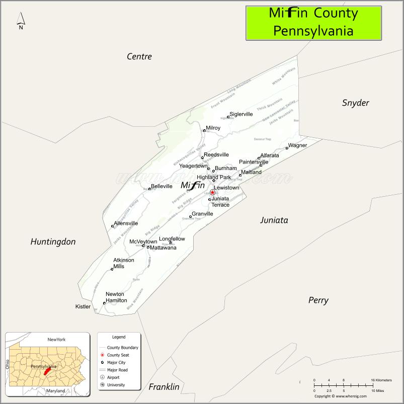
About Mifflin County Map, Pennsylvania: The map showing the county boundary, county seat, major cities, highways, water bodies and neighbouring counties.
Pennsylvania Related Links
About Mifflin County, Pennsylvania
Mifflin County is a county located in the U.S. state of Pennsylvania. It's county seat is Lewistown. As per 2020 census, the population of Mifflin County is 46136 people and population density is square miles. According to the United States Census Bureau, the county has a total area of 415 sq mi (1,075 km2). Mifflin County was established on 1789..
Facts about Mifflin County, Pennsylvania
| Country | United States |
| State | Pennsylvania |
| Region | Central Pennsylvania |
| County Seat | Lewistown |
| Named After | Thomas Mifflin |
| Established | 1789 |
| Organized | 1789 |
| Coordinates | 40.6015° N, 77.5716° W |
| Total Area | 415 sq mi |
| Land Area | 411 sq mi |
| Water Area | 4 sq mi |
| Population (2020 Census) | 46,211 |
| Population Rank | Smaller county in Pennsylvania |
| Major City | Lewistown |
| Main Industries | Manufacturing, Healthcare, Agriculture |
| Major Airport | None (nearest regional airports outside county) |
| Time Zone | Eastern Time (UTC−05:00) |
| Known For | Juniata River Valley, Historic railroads, Agriculture |
| Website | https://www.mifflincountypa.gov |
Top Attractions in Mifflin County, Pennsylvania
- Lewistown Narrows – Scenic river gorge views.
- Juniata River – Fishing and paddling.
- Reeds Gap State Park – Quiet park and trails.
- McCoy House Museum – Local history exhibits.
- Burnham Borough Park – Community park and events.
- Lewistown Historic District – Shops and architecture.
- Hawstone Creek Overlook – Scenic valley views.
- Seven Mountains Area (nearby) – Hiking and outdoor scenery.
- Big Valley Amish Community – Rural culture and farms.
- Lost Creek Shoe Shop – Restored 19th-century workshop.
- Kishacoquillas Valley Rail Trail – Walking and biking path.
- Smoker’s Park – County park and recreation.
Cities & Towns in Mifflin County, Pennsylvania
Lewistown, Burnham, McVeytown, Mount Union, Reedsville, Belleville, Juniata Terrace, Kistler, Granville, Strodes Mills, Milroy
- Adams County Map
- Allegheny County Map
- Armstrong County Map
- Beaver County Map
- Bedford County Map
- Berks County Map
- Blair County Map
- Bradford County Map
- Bucks County Map
- Butler County Map
- Cambria County Map
- Cameron County Map
- Carbon County Map
- Centre County Map
- Chester County Map
- Clarion County Map
- Clearfield County Map
- Clinton County Map
- Columbia County Map
- Crawford County Map
- Cumberland County Map
- Dauphin County Map
- Delaware County Map
- Elk County Map
- Erie County Map
- Fayette County Map
- Forest County Map
- Franklin County Map
- Fulton County Map
- Greene County Map
- Huntingdon County Map
- Indiana County Map
- Jefferson County Map
- Juniata County Map
- Lackawanna County Map
- Lancaster County Map
- Lawrence County Map
- Lebanon County Map
- Lehigh County Map
- Luzerne County Map
- Lycoming County Map
- McKean County Map
- Mercer County Map
- Mifflin County Map
- Monroe County Map
- Montgomery County Map
- Montour County Map
- Northampton County Map
- Northumberland County Map
- Perry County Map
- Philadelphia County Map
- Pike County Map
- Potter County Map
- Schuylkill County Map
- Snyder County Map
- Somerset County Map
- Sullivan County Map
- Susquehanna County Map
- Tioga County Map
- Union County Map
- Venango County Map
- Warren County Map
- Washington County Map
- Wayne County Map
- Westmoreland County Map
- Wyoming County Map
- York County Map
- Alabama Counties
- Alaska boroughs
- Arizona Counties
- Arkansas Counties
- California County Map
- Colorado Counties
- Connecticut Counties
- Delaware Counties
- Florida County Map
- Georgia County Map
- Hawaii Counties
- Idaho Counties
- Illinois Counties
- Indiana Counties
- Iowa Counties
- Kansas Counties
- Kentucky Counties
- Louisiana Counties
- Maine Counties
- Maryland Counties
- Massachusetts Counties
- Michigan County Map
- Minnesota Counties
- Mississippi Counties
- Missouri Counties
- Montana Counties
- Nebraska Counties
- Nevada Counties
- New York Counties
- New Hampshire Counties
- New Jersey Counties
- New Mexico Counties
- North Carolina Counties
- North Dakota Counties
- Ohio County Map
- Oklahoma Counties
- Oregon Counties
- Pennsylvania Counties
- Rhode Island Counties
- South Carolina Counties
- South Dakota Counties
- Map of Tennessee
- Texas County Map
- Utah Counties
- Vermont Counties
- Virginia Counties
- Washington Counties
- West Virginia Counties
- Wisconsin Counties
- Wyoming Counties