Written and Fact-checked by Whereig Editors | Updated On: May 01, 2026, 13:37 ET
Map of Butler County - Butler County is a county located in the U.S. state of Pennsylvania. Butler County Map showing cities, highways, important places and water bodies. Get Where is Butler County located in the map, major cities in Butler county, population, areas, and places of interest.
Map of Butler County, Pennsylvania
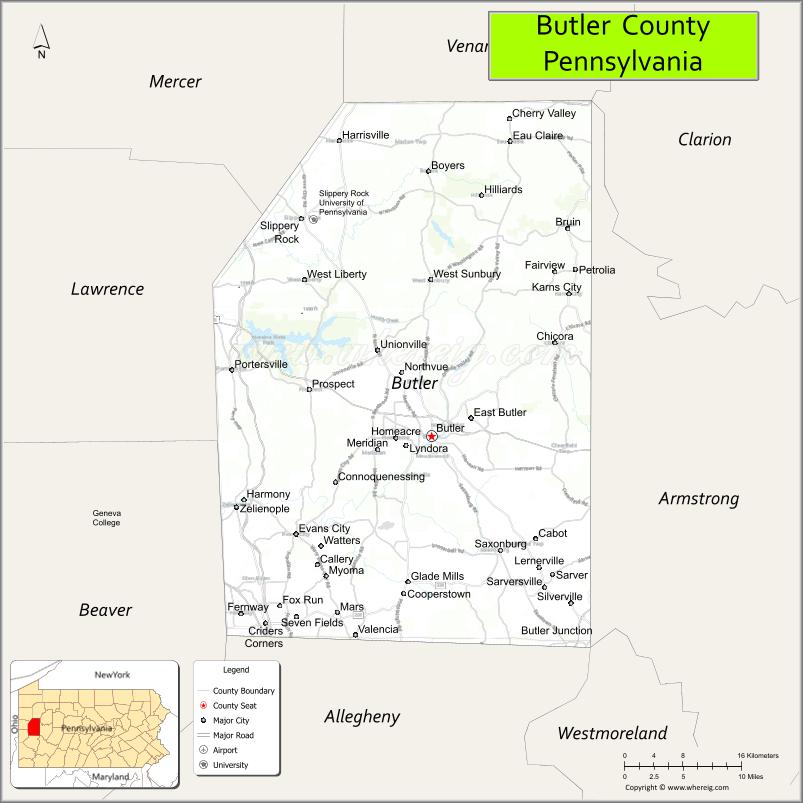
About Butler County Map, Pennsylvania: The map showing the county boundary, county seat, major cities, highways, water bodies and neighbouring counties.
Pennsylvania Related Links
About Butler County, Pennsylvania
Butler County is a county located in the U.S. state of Pennsylvania. It's county seat is Butler. As per 2020 census, the population of Butler County is 194273 people and population density is square miles. According to the United States Census Bureau, the county has a total area of 795 sq mi (2,059 km2). Butler County was established on 1800.
Facts about Butler County, Pennsylvania
| Country | United States |
| State | Pennsylvania |
| Region | Western Pennsylvania |
| County Seat | Butler |
| Named After | General Richard Butler |
| Established | 1800 |
| Organized | 1800 |
| Coordinates | 40.9110° N, 79.9196° W |
| Total Area | 795 sq mi |
| Land Area | 789 sq mi |
| Water Area | 6 sq mi |
| Population (2020 Census) | 193,763 |
| Population Rank | Mid-sized county in Pennsylvania |
| Major City | Butler |
| Main Industries | Manufacturing, Healthcare, Energy, Retail |
| Major Airport | Butler County Airport (BTP) |
| Time Zone | Eastern Time (UTC−05:00) |
| Known For | Oil history, Moraine State Park, Rolling hills |
| Website | https://www.butlercountypa.gov |
Top Attractions in Butler County, Pennsylvania
- Moraine State Park – Lake, trails, and boating.
- McConnells Mill State Park – Scenic gorge and waterfalls.
- Butler County Historical Society Museum – Local history exhibits.
- Slippery Rock University Campus – College setting and events.
- Jennings Environmental Education Center – Nature trails and prairie.
- Maridon Museum – Asian art and artifacts.
- Harmony Historic District – Historic village and architecture.
- North Country Trail – Hiking through forests.
- Pullman Park – Minor league baseball stadium.
- Lake Arthur – Recreation lake at Moraine.
- Historic Harmony Museum – Harmony Society history.
- Butler Downtown Historic District – Shops and architecture.
Cities & Towns in Butler County, Pennsylvania
Butler, Cranberry Township, Connoquenessing, Saxonburg, Mars, Prospect, Zelienople, Penn Township, Harmony, Evans City, Seven Fields, Meridian, Chicora, Bruin, Renfrew, Lyndora
- Adams County Map
- Allegheny County Map
- Armstrong County Map
- Beaver County Map
- Bedford County Map
- Berks County Map
- Blair County Map
- Bradford County Map
- Bucks County Map
- Butler County Map
- Cambria County Map
- Cameron County Map
- Carbon County Map
- Centre County Map
- Chester County Map
- Clarion County Map
- Clearfield County Map
- Clinton County Map
- Columbia County Map
- Crawford County Map
- Cumberland County Map
- Dauphin County Map
- Delaware County Map
- Elk County Map
- Erie County Map
- Fayette County Map
- Forest County Map
- Franklin County Map
- Fulton County Map
- Greene County Map
- Huntingdon County Map
- Indiana County Map
- Jefferson County Map
- Juniata County Map
- Lackawanna County Map
- Lancaster County Map
- Lawrence County Map
- Lebanon County Map
- Lehigh County Map
- Luzerne County Map
- Lycoming County Map
- McKean County Map
- Mercer County Map
- Mifflin County Map
- Monroe County Map
- Montgomery County Map
- Montour County Map
- Northampton County Map
- Northumberland County Map
- Perry County Map
- Philadelphia County Map
- Pike County Map
- Potter County Map
- Schuylkill County Map
- Snyder County Map
- Somerset County Map
- Sullivan County Map
- Susquehanna County Map
- Tioga County Map
- Union County Map
- Venango County Map
- Warren County Map
- Washington County Map
- Wayne County Map
- Westmoreland County Map
- Wyoming County Map
- York County Map
- Alabama Counties
- Alaska boroughs
- Arizona Counties
- Arkansas Counties
- California County Map
- Colorado Counties
- Connecticut Counties
- Delaware Counties
- Florida County Map
- Georgia County Map
- Hawaii Counties
- Idaho Counties
- Illinois Counties
- Indiana Counties
- Iowa Counties
- Kansas Counties
- Kentucky Counties
- Louisiana Counties
- Maine Counties
- Maryland Counties
- Massachusetts Counties
- Michigan County Map
- Minnesota Counties
- Mississippi Counties
- Missouri Counties
- Montana Counties
- Nebraska Counties
- Nevada Counties
- New York Counties
- New Hampshire Counties
- New Jersey Counties
- New Mexico Counties
- North Carolina Counties
- North Dakota Counties
- Ohio County Map
- Oklahoma Counties
- Oregon Counties
- Pennsylvania Counties
- Rhode Island Counties
- South Carolina Counties
- South Dakota Counties
- Map of Tennessee
- Texas County Map
- Utah Counties
- Vermont Counties
- Virginia Counties
- Washington Counties
- West Virginia Counties
- Wisconsin Counties
- Wyoming Counties