Written and Fact-checked by Whereig Editors | Updated On: May 01, 2026, 13:37 ET
Map of Washington County - Washington County is a county located in the U.S. state of Pennsylvania. Washington County Map showing cities, highways, important places and water bodies. Get Where is Washington County located in the map, major cities in Washington county, population, areas, and places of interest.
Map of Washington County, Pennsylvania
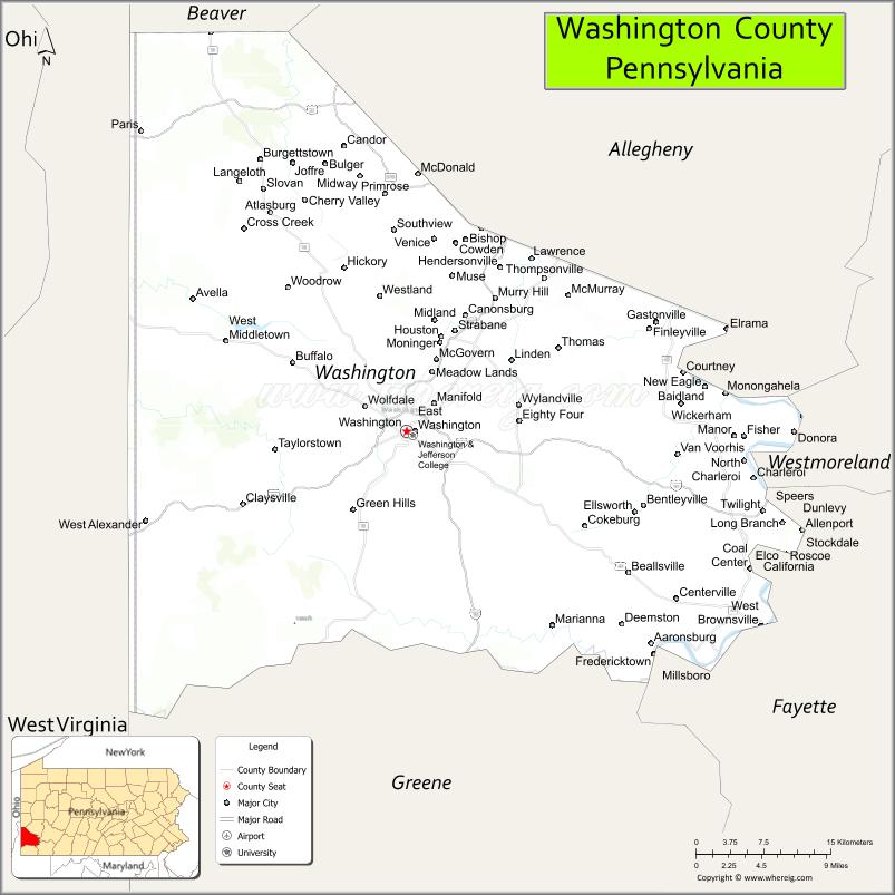
About Washington County Map, Pennsylvania: The map showing the county boundary, county seat, major cities, highways, water bodies and neighbouring counties.
Pennsylvania Related Links
About Washington County, Pennsylvania
Washington County is a county located in the U.S. state of Pennsylvania. It's county seat is Washington. As per 2020 census, the population of Washington County is 209470 people and population density is square miles. According to the United States Census Bureau, the county has a total area of 861 sq mi (2,230 km2). Washington County was established on 1781.
Facts about Washington County, Pennsylvania
| Country | United States |
| State | Pennsylvania |
| Region | Southwestern Pennsylvania |
| County Seat | Washington |
| Named After | George Washington |
| Established | 1781 |
| Organized | 1781 |
| Coordinates | 40.1736° N, 80.2462° W |
| Total Area | 861 sq mi |
| Land Area | 857 sq mi |
| Water Area | 4 sq mi |
| Population (2020 Census) | 209,349 |
| Population Rank | Mid-sized county in Pennsylvania |
| Major City | Washington |
| Main Industries | Energy, Manufacturing, Healthcare, Education |
| Major Airport | Washington County Airport (AFJ) |
| Time Zone | Eastern Time (UTC−05:00) |
| Known For | Energy production, Historic sites, Rolling hills |
| Website | https://www.washingtoncountypa.gov |
Top Attractions in Washington County, Pennsylvania
- Meadowcroft Rockshelter – Prehistoric archaeological site.
- Washington & Jefferson College Campus – Historic college grounds.
- Bradford House Museum – Whiskey Rebellion-era home.
- Pennsylvania Trolley Museum – Historic trolley rides.
- Cross Creek County Park – Lake, trails, and recreation.
- South Strabane Community Park – Sports fields and walking paths.
- Tanger Outlets Washington – Outlet shopping center.
- Washington County Courthouse – Historic government building.
- Chartiers Hill Historic Area – Scenic countryside views.
- Monongahela River – Fishing and river scenery.
- Hollywood Casino at The Meadows – Gaming and horse racing.
- Downtown Washington Historic District – Shops and local dining.
Cities & Towns in Washington County, Pennsylvania
Washington, Canonsburg, McDonald, Charleroi, Finleyville, Burgettstown, Bentleyville, Carmichaels, West Brownsville, Donora, Monongahela, Houston, Eighty Four, Beallsville, Monongahela Township
- Adams County Map
- Allegheny County Map
- Armstrong County Map
- Beaver County Map
- Bedford County Map
- Berks County Map
- Blair County Map
- Bradford County Map
- Bucks County Map
- Butler County Map
- Cambria County Map
- Cameron County Map
- Carbon County Map
- Centre County Map
- Chester County Map
- Clarion County Map
- Clearfield County Map
- Clinton County Map
- Columbia County Map
- Crawford County Map
- Cumberland County Map
- Dauphin County Map
- Delaware County Map
- Elk County Map
- Erie County Map
- Fayette County Map
- Forest County Map
- Franklin County Map
- Fulton County Map
- Greene County Map
- Huntingdon County Map
- Indiana County Map
- Jefferson County Map
- Juniata County Map
- Lackawanna County Map
- Lancaster County Map
- Lawrence County Map
- Lebanon County Map
- Lehigh County Map
- Luzerne County Map
- Lycoming County Map
- McKean County Map
- Mercer County Map
- Mifflin County Map
- Monroe County Map
- Montgomery County Map
- Montour County Map
- Northampton County Map
- Northumberland County Map
- Perry County Map
- Philadelphia County Map
- Pike County Map
- Potter County Map
- Schuylkill County Map
- Snyder County Map
- Somerset County Map
- Sullivan County Map
- Susquehanna County Map
- Tioga County Map
- Union County Map
- Venango County Map
- Warren County Map
- Washington County Map
- Wayne County Map
- Westmoreland County Map
- Wyoming County Map
- York County Map
- Alabama Counties
- Alaska boroughs
- Arizona Counties
- Arkansas Counties
- California County Map
- Colorado Counties
- Connecticut Counties
- Delaware Counties
- Florida County Map
- Georgia County Map
- Hawaii Counties
- Idaho Counties
- Illinois Counties
- Indiana Counties
- Iowa Counties
- Kansas Counties
- Kentucky Counties
- Louisiana Counties
- Maine Counties
- Maryland Counties
- Massachusetts Counties
- Michigan County Map
- Minnesota Counties
- Mississippi Counties
- Missouri Counties
- Montana Counties
- Nebraska Counties
- Nevada Counties
- New York Counties
- New Hampshire Counties
- New Jersey Counties
- New Mexico Counties
- North Carolina Counties
- North Dakota Counties
- Ohio County Map
- Oklahoma Counties
- Oregon Counties
- Pennsylvania Counties
- Rhode Island Counties
- South Carolina Counties
- South Dakota Counties
- Map of Tennessee
- Texas County Map
- Utah Counties
- Vermont Counties
- Virginia Counties
- Washington Counties
- West Virginia Counties
- Wisconsin Counties
- Wyoming Counties