Written and Fact-checked by Whereig Editors | Updated On: May 01, 2026, 13:37 ET
Map of Mercer County - Mercer County is a county located in the U.S. state of Pennsylvania. Mercer County Map showing cities, highways, important places and water bodies. Get Where is Mercer County located in the map, major cities in Mercer county, population, areas, and places of interest.
Map of Mercer County, Pennsylvania
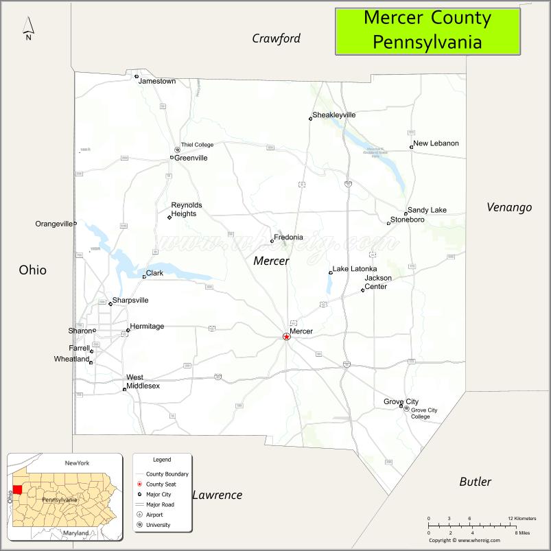
About Mercer County Map, Pennsylvania: The map showing the county boundary, county seat, major cities, highways, water bodies and neighbouring counties.
Pennsylvania Related Links
About Mercer County, Pennsylvania
Mercer County is a county located in the U.S. state of Pennsylvania. It's county seat is Mercer. As per 2020 census, the population of Mercer County is 109972 people and population density is square miles. According to the United States Census Bureau, the county has a total area of 683 sq mi (1,769 km2). Mercer County was established on 1800.
Facts about Mercer County, Pennsylvania
| Country | United States |
| State | Pennsylvania |
| Region | Western Pennsylvania |
| County Seat | Mercer |
| Named After | General Hugh Mercer |
| Established | 1800 |
| Organized | 1800 |
| Coordinates | 41.3007° N, 80.2534° W |
| Total Area | 683 sq mi |
| Land Area | 674 sq mi |
| Water Area | 9 sq mi |
| Population (2020 Census) | 110,652 |
| Population Rank | Mid-sized county in Pennsylvania |
| Major City | Hermitage |
| Main Industries | Manufacturing, Healthcare, Education, Retail |
| Major Airport | Youngstown–Warren Regional Airport (YNG) |
| Time Zone | Eastern Time (UTC−05:00) |
| Known For | Pymatuning Reservoir, Shenango Valley, Industrial heritage |
| Website | https://www.mercercountypa.gov |
Top Attractions in Mercer County, Pennsylvania
- Grove City Premium Outlets – Large outlet shopping center.
- Mercer County Courthouse – Historic government building.
- Trinity Living History Museum – 19th-century village site.
- Moraine State Park (nearby) – Lake and outdoor recreation.
- Lake Wilhelm (nearby) – Boating and fishing lake.
- Spring Valley Golf Club – Scenic golfing destination.
- Mercer County Historical Society – Local history exhibits.
- Shenango River – Fishing and paddling.
- Downtown Sharon Historic District – Shops and dining.
- Buhl Park – Gardens and recreation.
- Shenango Valley Mall – Shopping and dining.
- Keystone Safari (nearby) – Drive-through animal park.
Cities & Towns in Mercer County, Pennsylvania
Hermitage, Sharon, Farrell, Greenville, Mercer, Grove City, Celina, Sharpsville, Jackson Center, West Middlesex, Wheatland, Clark, Fredonia, Coolspring, Pine Township, Findley Township
- Adams County Map
- Allegheny County Map
- Armstrong County Map
- Beaver County Map
- Bedford County Map
- Berks County Map
- Blair County Map
- Bradford County Map
- Bucks County Map
- Butler County Map
- Cambria County Map
- Cameron County Map
- Carbon County Map
- Centre County Map
- Chester County Map
- Clarion County Map
- Clearfield County Map
- Clinton County Map
- Columbia County Map
- Crawford County Map
- Cumberland County Map
- Dauphin County Map
- Delaware County Map
- Elk County Map
- Erie County Map
- Fayette County Map
- Forest County Map
- Franklin County Map
- Fulton County Map
- Greene County Map
- Huntingdon County Map
- Indiana County Map
- Jefferson County Map
- Juniata County Map
- Lackawanna County Map
- Lancaster County Map
- Lawrence County Map
- Lebanon County Map
- Lehigh County Map
- Luzerne County Map
- Lycoming County Map
- McKean County Map
- Mercer County Map
- Mifflin County Map
- Monroe County Map
- Montgomery County Map
- Montour County Map
- Northampton County Map
- Northumberland County Map
- Perry County Map
- Philadelphia County Map
- Pike County Map
- Potter County Map
- Schuylkill County Map
- Snyder County Map
- Somerset County Map
- Sullivan County Map
- Susquehanna County Map
- Tioga County Map
- Union County Map
- Venango County Map
- Warren County Map
- Washington County Map
- Wayne County Map
- Westmoreland County Map
- Wyoming County Map
- York County Map
- Alabama Counties
- Alaska boroughs
- Arizona Counties
- Arkansas Counties
- California County Map
- Colorado Counties
- Connecticut Counties
- Delaware Counties
- Florida County Map
- Georgia County Map
- Hawaii Counties
- Idaho Counties
- Illinois Counties
- Indiana Counties
- Iowa Counties
- Kansas Counties
- Kentucky Counties
- Louisiana Counties
- Maine Counties
- Maryland Counties
- Massachusetts Counties
- Michigan County Map
- Minnesota Counties
- Mississippi Counties
- Missouri Counties
- Montana Counties
- Nebraska Counties
- Nevada Counties
- New York Counties
- New Hampshire Counties
- New Jersey Counties
- New Mexico Counties
- North Carolina Counties
- North Dakota Counties
- Ohio County Map
- Oklahoma Counties
- Oregon Counties
- Pennsylvania Counties
- Rhode Island Counties
- South Carolina Counties
- South Dakota Counties
- Map of Tennessee
- Texas County Map
- Utah Counties
- Vermont Counties
- Virginia Counties
- Washington Counties
- West Virginia Counties
- Wisconsin Counties
- Wyoming Counties