Written and Fact-checked by Whereig Editors | Updated On: May 01, 2026, 13:37 ET
Map of Northampton County - Northampton County is a county located in the U.S. state of Pennsylvania. Northampton County Map showing cities, highways, important places and water bodies. Get Where is Northampton County located in the map, major cities in Northampton county, population, areas, and places of interest.
Map of Northampton County, Pennsylvania
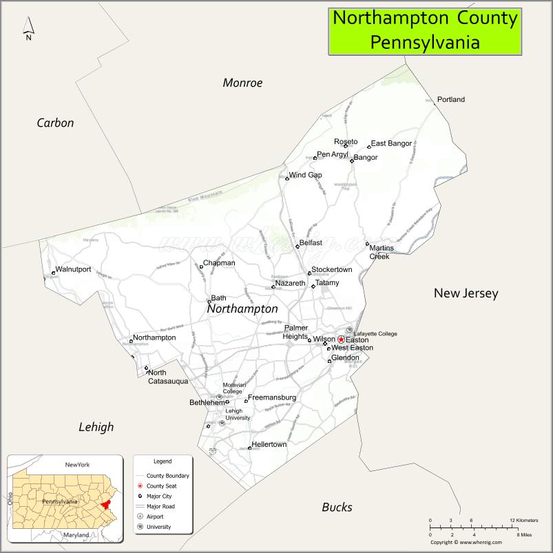
About Northampton County Map, Pennsylvania: The map showing the county boundary, county seat, major cities, highways, water bodies and neighbouring counties.
Pennsylvania Related Links
About Northampton County, Pennsylvania
Northampton County is a county located in the U.S. state of Pennsylvania. It's county seat is Easton. As per 2020 census, the population of Northampton County is 313628 people and population density is square miles. According to the United States Census Bureau, the county has a total area of 377 sq mi (976 km2). Northampton County was established on 1752.
<Facts about Northampton County, Pennsylvania
| Country | United States |
| State | Pennsylvania |
| Region | Eastern Pennsylvania |
| County Seat | Easton |
| Named After | Northamptonshire, England |
| Established | 1752 |
| Organized | 1752 |
| Coordinates | 40.7549° N, 75.3076° W |
| Total Area | 377 sq mi |
| Land Area | 369 sq mi |
| Water Area | 8 sq mi |
| Population (2020 Census) | 312,951 |
| Population Rank | Mid-sized county in Pennsylvania |
| Major City | Easton |
| Main Industries | Healthcare, Manufacturing, Logistics, Education |
| Major Airport | Lehigh Valley International Airport (ABE) |
| Time Zone | Eastern Time (UTC−05:00) |
| Known For | Lehigh Valley, Industrial history, Delaware River towns |
| Website | https://www.northamptoncounty.org |
Top Attractions in Northampton County, Pennsylvania
- Historic Bethlehem – Moravian history and downtown charm.
- SteelStacks – Arts campus and events venue.
- National Museum of Industrial History – American industry exhibits.
- Lehigh Valley Zoo (nearby) – Family-friendly wildlife exhibits.
- Jacobsburg Environmental Education Center – Trails and nature programs.
- Northampton County Canal Trail – Walking and biking path.
- Burnside Plantation – Historic farm and mill.
- Martin Guitar Factory (nearby) – Guitar-making tours.
- Downtown Easton Historic District – Shops, dining, and markets.
- Crayola Experience (nearby) – Interactive family attraction.
- Bushy Run Battlefield (nearby) – French and Indian War site.
- Delaware & Lehigh National Heritage Corridor – Scenic heritage trails.
Cities & Towns in Northampton County, Pennsylvania
Easton, Bethlehem, Nazareth, Northampton, Wilson, Hellertown, Bath, Bangor, Pen Argyl, Stockertown, Tatamy, Wind Gap, Freemansburg, Moore Township, Lower Saucon
- Adams County Map
- Allegheny County Map
- Armstrong County Map
- Beaver County Map
- Bedford County Map
- Berks County Map
- Blair County Map
- Bradford County Map
- Bucks County Map
- Butler County Map
- Cambria County Map
- Cameron County Map
- Carbon County Map
- Centre County Map
- Chester County Map
- Clarion County Map
- Clearfield County Map
- Clinton County Map
- Columbia County Map
- Crawford County Map
- Cumberland County Map
- Dauphin County Map
- Delaware County Map
- Elk County Map
- Erie County Map
- Fayette County Map
- Forest County Map
- Franklin County Map
- Fulton County Map
- Greene County Map
- Huntingdon County Map
- Indiana County Map
- Jefferson County Map
- Juniata County Map
- Lackawanna County Map
- Lancaster County Map
- Lawrence County Map
- Lebanon County Map
- Lehigh County Map
- Luzerne County Map
- Lycoming County Map
- McKean County Map
- Mercer County Map
- Mifflin County Map
- Monroe County Map
- Montgomery County Map
- Montour County Map
- Northampton County Map
- Northumberland County Map
- Perry County Map
- Philadelphia County Map
- Pike County Map
- Potter County Map
- Schuylkill County Map
- Snyder County Map
- Somerset County Map
- Sullivan County Map
- Susquehanna County Map
- Tioga County Map
- Union County Map
- Venango County Map
- Warren County Map
- Washington County Map
- Wayne County Map
- Westmoreland County Map
- Wyoming County Map
- York County Map
- Alabama Counties
- Alaska boroughs
- Arizona Counties
- Arkansas Counties
- California County Map
- Colorado Counties
- Connecticut Counties
- Delaware Counties
- Florida County Map
- Georgia County Map
- Hawaii Counties
- Idaho Counties
- Illinois Counties
- Indiana Counties
- Iowa Counties
- Kansas Counties
- Kentucky Counties
- Louisiana Counties
- Maine Counties
- Maryland Counties
- Massachusetts Counties
- Michigan County Map
- Minnesota Counties
- Mississippi Counties
- Missouri Counties
- Montana Counties
- Nebraska Counties
- Nevada Counties
- New York Counties
- New Hampshire Counties
- New Jersey Counties
- New Mexico Counties
- North Carolina Counties
- North Dakota Counties
- Ohio County Map
- Oklahoma Counties
- Oregon Counties
- Pennsylvania Counties
- Rhode Island Counties
- South Carolina Counties
- South Dakota Counties
- Map of Tennessee
- Texas County Map
- Utah Counties
- Vermont Counties
- Virginia Counties
- Washington Counties
- West Virginia Counties
- Wisconsin Counties
- Wyoming Counties