Written and Fact-checked by Whereig Editors | Updated On: May 01, 2026, 13:37 ET
Map of Dauphin County - Dauphin County is a county located in the U.S. state of Pennsylvania. Dauphin County Map showing cities, highways, important places and water bodies. Get Where is Dauphin County located in the map, major cities in Dauphin county, population, areas, and places of interest.
Map of Dauphin County, Pennsylvania
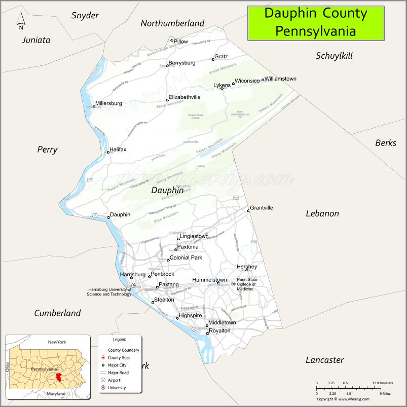
About Dauphin County Map, Pennsylvania: The map showing the county boundary, county seat, major cities, highways, water bodies and neighbouring counties.
Pennsylvania Related Links
About Dauphin County, Pennsylvania
Dauphin County is a county located in the U.S. state of Pennsylvania. It's county seat is Harrisburg. As per 2020 census, the population of Dauphin County is 287400 people and population density is square miles. According to the United States Census Bureau, the county has a total area of 558 sq mi (1,445 km2). Dauphin County was established on 1785.
Facts about Dauphin County, Pennsylvania
| Country | United States |
| State | Pennsylvania |
| Region | South Central Pennsylvania |
| County Seat | Harrisburg |
| Named After | Louis-Joseph, Dauphin of France |
| Established | 1785 |
| Organized | 1785 |
| Coordinates | 40.4135° N, 76.7795° W |
| Total Area | 558 sq mi |
| Land Area | 525 sq mi |
| Water Area | 33 sq mi |
| Population (2020 Census) | 286,401 |
| Population Rank | Mid-sized county in Pennsylvania |
| Major City | Harrisburg |
| Main Industries | Government, Healthcare, Manufacturing, Transportation |
| Major Airport | Harrisburg International Airport (MDT) |
| Time Zone | Eastern Time (UTC−05:00) |
| Known For | Pennsylvania State Capitol, Hersheypark, Susquehanna River |
| Website | https://www.dauphincounty.gov |
Top Attractions in Dauphin County, Pennsylvania
- Hersheypark – Major amusement park and rides.
- Hershey’s Chocolate World – Chocolate-themed attraction.
- Pennsylvania State Capitol – Historic government building.
- State Museum of Pennsylvania – History and science exhibits.
- National Civil War Museum – Comprehensive Civil War history.
- Hershey Gardens – Botanical gardens and butterfly house.
- Susquehanna Riverfront Park – River views and walking paths.
- Fort Hunter Mansion and Park – Historic riverside estate.
- Whitaker Center for Science and the Arts – IMAX and exhibits.
- Italian Lake Park – Urban park and lake.
- Broad Street Market – Historic indoor market.
- Hershey Theatre – Performing arts venue.
Cities & Towns in Dauphin County, Pennsylvania
Harrisburg, Hershey, Steelton, Middletown, Highspire, Palmyra, Hummelstown, Lower Swatara, Swatara, Lower Paxton, East Hanover, West Hanover, Derry
- Adams County Map
- Allegheny County Map
- Armstrong County Map
- Beaver County Map
- Bedford County Map
- Berks County Map
- Blair County Map
- Bradford County Map
- Bucks County Map
- Butler County Map
- Cambria County Map
- Cameron County Map
- Carbon County Map
- Centre County Map
- Chester County Map
- Clarion County Map
- Clearfield County Map
- Clinton County Map
- Columbia County Map
- Crawford County Map
- Cumberland County Map
- Dauphin County Map
- Delaware County Map
- Elk County Map
- Erie County Map
- Fayette County Map
- Forest County Map
- Franklin County Map
- Fulton County Map
- Greene County Map
- Huntingdon County Map
- Indiana County Map
- Jefferson County Map
- Juniata County Map
- Lackawanna County Map
- Lancaster County Map
- Lawrence County Map
- Lebanon County Map
- Lehigh County Map
- Luzerne County Map
- Lycoming County Map
- McKean County Map
- Mercer County Map
- Mifflin County Map
- Monroe County Map
- Montgomery County Map
- Montour County Map
- Northampton County Map
- Northumberland County Map
- Perry County Map
- Philadelphia County Map
- Pike County Map
- Potter County Map
- Schuylkill County Map
- Snyder County Map
- Somerset County Map
- Sullivan County Map
- Susquehanna County Map
- Tioga County Map
- Union County Map
- Venango County Map
- Warren County Map
- Washington County Map
- Wayne County Map
- Westmoreland County Map
- Wyoming County Map
- York County Map
- Alabama Counties
- Alaska boroughs
- Arizona Counties
- Arkansas Counties
- California County Map
- Colorado Counties
- Connecticut Counties
- Delaware Counties
- Florida County Map
- Georgia County Map
- Hawaii Counties
- Idaho Counties
- Illinois Counties
- Indiana Counties
- Iowa Counties
- Kansas Counties
- Kentucky Counties
- Louisiana Counties
- Maine Counties
- Maryland Counties
- Massachusetts Counties
- Michigan County Map
- Minnesota Counties
- Mississippi Counties
- Missouri Counties
- Montana Counties
- Nebraska Counties
- Nevada Counties
- New York Counties
- New Hampshire Counties
- New Jersey Counties
- New Mexico Counties
- North Carolina Counties
- North Dakota Counties
- Ohio County Map
- Oklahoma Counties
- Oregon Counties
- Pennsylvania Counties
- Rhode Island Counties
- South Carolina Counties
- South Dakota Counties
- Map of Tennessee
- Texas County Map
- Utah Counties
- Vermont Counties
- Virginia Counties
- Washington Counties
- West Virginia Counties
- Wisconsin Counties
- Wyoming Counties