Written and Fact-checked by Whereig Editors | Updated On: May 01, 2026, 13:37 ET
Map of Erie County - Erie County is a county located in the U.S. state of Pennsylvania. Erie County Map showing cities, highways, important places and water bodies. Get Where is Erie County located in the map, major cities in Erie county, population, areas, and places of interest.
Map of Erie County, Pennsylvania
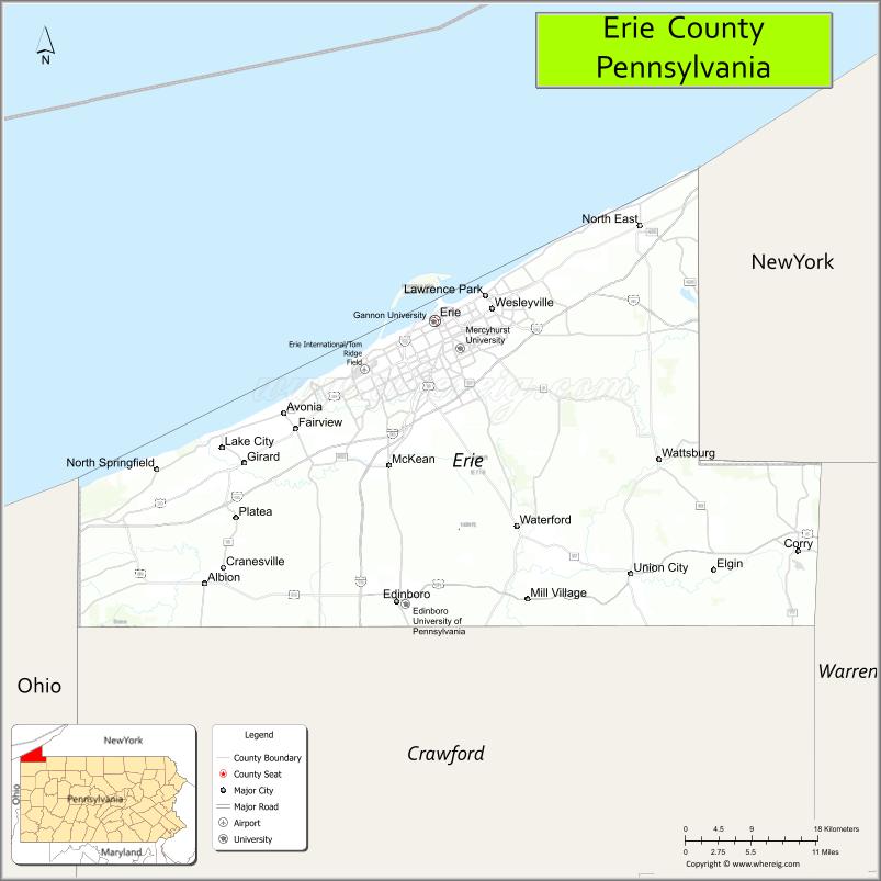
About Erie County Map, Pennsylvania: The map showing the county boundary, county seat, major cities, highways, water bodies and neighbouring counties.
Pennsylvania Related Links
About Erie County, Pennsylvania
Erie County is a county located in the U.S. state of Pennsylvania. It's county seat is Erie. As per 2020 census, the population of Erie County is 269011 people and population density is square miles. According to the United States Census Bureau, the county has a total area of 799 sq mi (2,069 km2). Erie County was established on 1800.
Facts about Erie County, Pennsylvania
| Country | United States |
| State | Pennsylvania |
| Region | Northwestern Pennsylvania |
| County Seat | Erie |
| Named After | Lake Erie |
| Established | 1800 |
| Organized | 1800 |
| Coordinates | 42.1292° N, 80.0851° W |
| Total Area | 799 sq mi |
| Land Area | 644 sq mi |
| Water Area | 155 sq mi |
| Population (2020 Census) | 270,876 |
| Population Rank | Mid-sized county in Pennsylvania |
| Major City | Erie |
| Main Industries | Manufacturing, Healthcare, Education, Transportation |
| Major Airport | Erie International Airport (ERI) |
| Time Zone | Eastern Time (UTC−05:00) |
| Known For | Lake Erie shoreline, Presque Isle State Park, Port of Erie |
| Website | https://eriecountypa.gov |
Top Attractions in Erie County, Pennsylvania
- Presque Isle State Park – Beaches, trails, and lake views.
- Erie Maritime Museum – Naval history and exhibits.
- USS Niagara – Restored War of 1812 flagship.
- Waldameer & Water World – Classic amusement park.
- Erie Zoo – Family-friendly animal exhibits.
- Bayfront District – Waterfront dining and events.
- Tom Ridge Environmental Center – Nature exhibits and observation tower.
- Millcreek Mall – Shopping and dining.
- Erie Art Museum – Regional art collections.
- Port Erie Bicentennial Tower – Observation deck views.
- Lake Erie Wine Country – Wineries and tastings.
- Frontier Park – Historic city park.
Cities & Towns in Erie County, Pennsylvania
Erie, Edinboro, Fairview, Corry, Harborcreek, Millcreek, Girard, North East, Wattsburg, Waterford, Summit Township, Union City, Albion, Franklin Township, McKean, Venango, Lawrence Park
- Adams County Map
- Allegheny County Map
- Armstrong County Map
- Beaver County Map
- Bedford County Map
- Berks County Map
- Blair County Map
- Bradford County Map
- Bucks County Map
- Butler County Map
- Cambria County Map
- Cameron County Map
- Carbon County Map
- Centre County Map
- Chester County Map
- Clarion County Map
- Clearfield County Map
- Clinton County Map
- Columbia County Map
- Crawford County Map
- Cumberland County Map
- Dauphin County Map
- Delaware County Map
- Elk County Map
- Erie County Map
- Fayette County Map
- Forest County Map
- Franklin County Map
- Fulton County Map
- Greene County Map
- Huntingdon County Map
- Indiana County Map
- Jefferson County Map
- Juniata County Map
- Lackawanna County Map
- Lancaster County Map
- Lawrence County Map
- Lebanon County Map
- Lehigh County Map
- Luzerne County Map
- Lycoming County Map
- McKean County Map
- Mercer County Map
- Mifflin County Map
- Monroe County Map
- Montgomery County Map
- Montour County Map
- Northampton County Map
- Northumberland County Map
- Perry County Map
- Philadelphia County Map
- Pike County Map
- Potter County Map
- Schuylkill County Map
- Snyder County Map
- Somerset County Map
- Sullivan County Map
- Susquehanna County Map
- Tioga County Map
- Union County Map
- Venango County Map
- Warren County Map
- Washington County Map
- Wayne County Map
- Westmoreland County Map
- Wyoming County Map
- York County Map
- Alabama Counties
- Alaska boroughs
- Arizona Counties
- Arkansas Counties
- California County Map
- Colorado Counties
- Connecticut Counties
- Delaware Counties
- Florida County Map
- Georgia County Map
- Hawaii Counties
- Idaho Counties
- Illinois Counties
- Indiana Counties
- Iowa Counties
- Kansas Counties
- Kentucky Counties
- Louisiana Counties
- Maine Counties
- Maryland Counties
- Massachusetts Counties
- Michigan County Map
- Minnesota Counties
- Mississippi Counties
- Missouri Counties
- Montana Counties
- Nebraska Counties
- Nevada Counties
- New York Counties
- New Hampshire Counties
- New Jersey Counties
- New Mexico Counties
- North Carolina Counties
- North Dakota Counties
- Ohio County Map
- Oklahoma Counties
- Oregon Counties
- Pennsylvania Counties
- Rhode Island Counties
- South Carolina Counties
- South Dakota Counties
- Map of Tennessee
- Texas County Map
- Utah Counties
- Vermont Counties
- Virginia Counties
- Washington Counties
- West Virginia Counties
- Wisconsin Counties
- Wyoming Counties