Written and Fact-checked by Whereig Editors | Updated On: May 01, 2026, 13:37 ET
Map of Fayette County - Fayette County is a county located in the U.S. state of Pennsylvania. Fayette County Map showing cities, highways, important places and water bodies. Get Where is Fayette County located in the map, major cities in Fayette county, population, areas, and places of interest.
Map of Fayette County, Pennsylvania
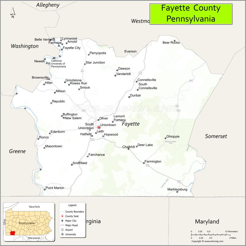
About Fayette County Map, Pennsylvania: The map showing the county boundary, county seat, major cities, highways, water bodies and neighbouring counties.
Pennsylvania Related Links
About Fayette County, Pennsylvania
Fayette County is a county located in the U.S. state of Pennsylvania. It's county seat is Uniontown. As per 2020 census, the population of Fayette County is 126931 people and population density is square miles. According to the United States Census Bureau, the county has a total area of 798 sq mi (2,067 km2). Fayette County was established on 1783.
Facts about Fayette County, Pennsylvania
| Country | United States |
| State | Pennsylvania |
| Region | Southwestern Pennsylvania |
| County Seat | Uniontown |
| Named After | Marquis de Lafayette |
| Established | 1783 |
| Organized | 1783 |
| Coordinates | 39.9190° N, 79.6507° W |
| Total Area | 798 sq mi |
| Land Area | 790 sq mi |
| Water Area | 8 sq mi |
| Population (2020 Census) | 128,804 |
| Population Rank | Mid-sized county in Pennsylvania |
| Major City | Uniontown |
| Main Industries | Healthcare, Manufacturing, Energy, Tourism |
| Major Airport | Joseph A. Hardy Connellsville Airport (WVI) |
| Time Zone | Eastern Time (UTC−05:00) |
| Known For | Frank Lloyd Wright’s Fallingwater, Laurel Highlands, Coal history |
| Website | https://www.fayettecountypa.org |
Top Attractions in Fayette County, Pennsylvania
- Fallingwater – Frank Lloyd Wright architectural masterpiece.
- Ohiopyle State Park – Waterfalls, hiking, and rafting.
- Fort Necessity National Battlefield – French and Indian War site.
- Kentuck Knob – Frank Lloyd Wright-designed home.
- Laurel Caverns – Underground cave tours.
- Great Allegheny Passage – Popular biking and hiking trail.
- Youghiogheny River – Whitewater rafting and fishing.
- Uniontown Downtown Historic District – Shops and local history.
- Friendship Hill National Historic Site – Albert Gallatin’s estate.
- Chestnut Ridge Resort Area – Scenic mountain views.
- Hopwood Covered Bridge – Historic wooden bridge.
- State Theatre Center for the Arts – Live performances and events.
Cities & Towns in Fayette County, Pennsylvania
Uniontown, Connellsville, Masontown, Brownsville, Belle Vernon, Dunbar, Charleroi, Perryopolis, Fairchance, Newell, Smithfield, Scottdale, Point Marion, Vanderbilt, Ohiopyle, North Union, Jefferson Township
- Adams County Map
- Allegheny County Map
- Armstrong County Map
- Beaver County Map
- Bedford County Map
- Berks County Map
- Blair County Map
- Bradford County Map
- Bucks County Map
- Butler County Map
- Cambria County Map
- Cameron County Map
- Carbon County Map
- Centre County Map
- Chester County Map
- Clarion County Map
- Clearfield County Map
- Clinton County Map
- Columbia County Map
- Crawford County Map
- Cumberland County Map
- Dauphin County Map
- Delaware County Map
- Elk County Map
- Erie County Map
- Fayette County Map
- Forest County Map
- Franklin County Map
- Fulton County Map
- Greene County Map
- Huntingdon County Map
- Indiana County Map
- Jefferson County Map
- Juniata County Map
- Lackawanna County Map
- Lancaster County Map
- Lawrence County Map
- Lebanon County Map
- Lehigh County Map
- Luzerne County Map
- Lycoming County Map
- McKean County Map
- Mercer County Map
- Mifflin County Map
- Monroe County Map
- Montgomery County Map
- Montour County Map
- Northampton County Map
- Northumberland County Map
- Perry County Map
- Philadelphia County Map
- Pike County Map
- Potter County Map
- Schuylkill County Map
- Snyder County Map
- Somerset County Map
- Sullivan County Map
- Susquehanna County Map
- Tioga County Map
- Union County Map
- Venango County Map
- Warren County Map
- Washington County Map
- Wayne County Map
- Westmoreland County Map
- Wyoming County Map
- York County Map
- Alabama Counties
- Alaska boroughs
- Arizona Counties
- Arkansas Counties
- California County Map
- Colorado Counties
- Connecticut Counties
- Delaware Counties
- Florida County Map
- Georgia County Map
- Hawaii Counties
- Idaho Counties
- Illinois Counties
- Indiana Counties
- Iowa Counties
- Kansas Counties
- Kentucky Counties
- Louisiana Counties
- Maine Counties
- Maryland Counties
- Massachusetts Counties
- Michigan County Map
- Minnesota Counties
- Mississippi Counties
- Missouri Counties
- Montana Counties
- Nebraska Counties
- Nevada Counties
- New York Counties
- New Hampshire Counties
- New Jersey Counties
- New Mexico Counties
- North Carolina Counties
- North Dakota Counties
- Ohio County Map
- Oklahoma Counties
- Oregon Counties
- Pennsylvania Counties
- Rhode Island Counties
- South Carolina Counties
- South Dakota Counties
- Map of Tennessee
- Texas County Map
- Utah Counties
- Vermont Counties
- Virginia Counties
- Washington Counties
- West Virginia Counties
- Wisconsin Counties
- Wyoming Counties